Pantego Topo Map North Carolina
To zoom in, hover over the map of Pantego
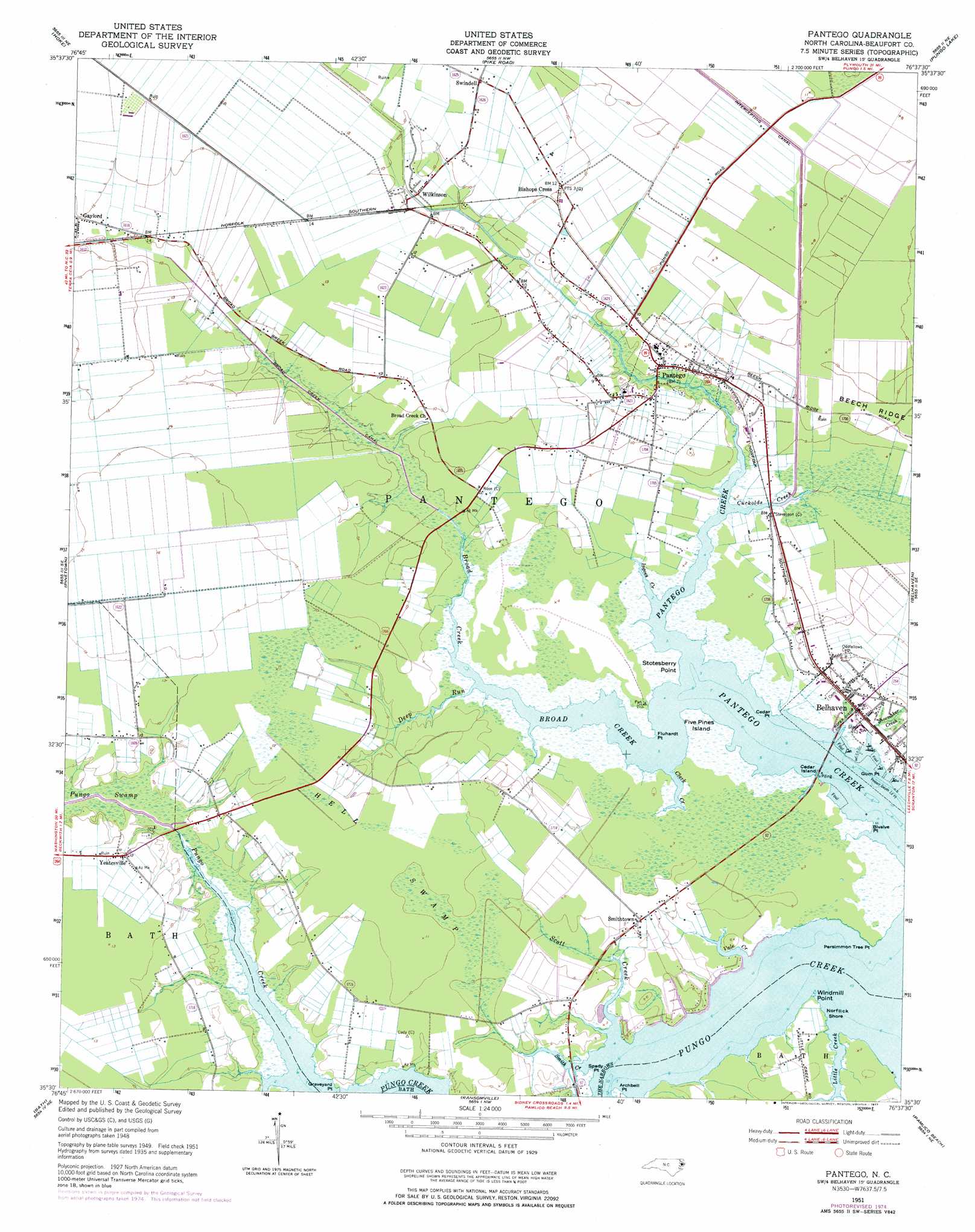
USGS Topo Quad 35076e6 - 1:24,000 scale
| Topo Map Name: | Pantego |
| USGS Topo Quad ID: | 35076e6 |
| Print Size: | ca. 21 1/4" wide x 27" high |
| Southeast Coordinates: | 35.5° N latitude / 76.625° W longitude |
| Map Center Coordinates: | 35.5625° N latitude / 76.6875° W longitude |
| U.S. State: | NC |
| Filename: | o35076e6.jpg |
| Download Map JPG Image: | Pantego topo map 1:24,000 scale |
| Map Type: | Topographic |
| Topo Series: | 7.5´ |
| Map Scale: | 1:24,000 |
| Source of Map Images: | United States Geological Survey (USGS) |
| Alternate Map Versions: |
Pantego NC 1951, updated 1953 Download PDF Buy paper map Pantego NC 1951, updated 1977 Download PDF Buy paper map Pantego NC 2010 Download PDF Buy paper map Pantego NC 2013 Download PDF Buy paper map Pantego NC 2016 Download PDF Buy paper map |
1:24,000 Topo Quads surrounding Pantego
Jamesville |
Plymouth West |
Plymouth East |
Roper South |
Creswell |
Farmlife |
Hoke |
Pike Road |
Pungo Lake |
New Lake Nw |
Bunyan |
Pinetown |
Pantego |
Belhaven |
Ponzer |
Blounts Bay |
Bath |
Ransomville |
Pamlico Beach |
Scranton |
Edward |
Aurora |
South Creek |
Lowland |
Pamlico Point |
> Back to 35076e1 at 1:100,000 scale
> Back to 35076a1 at 1:250,000 scale
> Back to U.S. Topo Maps home
Pantego topo map: Gazetteer
Pantego: Beaches
Norflick Shore elevation 1m 3′Pantego: Canals
Broad Creek Canal elevation 1m 3′Roper Ditch elevation 0m 0′
Pantego: Capes
Archbell Point elevation 1m 3′Bivalve Point elevation 1m 3′
Cedar Point elevation 1m 3′
Fluhardt Point elevation 0m 0′
Graveyard Point elevation 2m 6′
Gum Point elevation 0m 0′
Persimmon Tree Point elevation 1m 3′
Spady Point elevation 1m 3′
Stotesberry Point elevation 1m 3′
Windmill Point elevation 1m 3′
Pantego: Channels
The Narrows elevation 0m 0′Pantego: Islands
Cedar Island elevation 1m 3′Five Pines Island elevation 1m 3′
Pantego: Populated Places
Bishops Cross elevation 3m 9′Gaylord elevation 4m 13′
Pantego elevation 1m 3′
Smithtown elevation 2m 6′
Swindell elevation 3m 9′
Wilkinson elevation 3m 9′
Yeatesville elevation 3m 9′
Pantego: Post Offices
Belhaven Post Office elevation 1m 3′Pantego: Streams
Broad Creek elevation -1m -4′Clark Creek elevation -1m -4′
Cuckolds Creek elevation 0m 0′
Deep Run elevation 0m 0′
Ingoes Creek elevation -1m -4′
Little Creek elevation 0m 0′
Old Mill Creek elevation 0m 0′
Pungo Swamp elevation 0m 0′
Scott Creek elevation 0m 0′
Shoemaker Creek elevation 0m 0′
Smith Creek elevation 0m 0′
Vale Creek elevation 7m 22′
Pantego: Swamps
Hell Swamp elevation 3m 9′Pantego digital topo map on disk
Buy this Pantego topo map showing relief, roads, GPS coordinates and other geographical features, as a high-resolution digital map file on DVD:
Atlantic Coast (NY, NJ, PA, DE, MD, VA, NC)
Buy digital topo maps: Atlantic Coast (NY, NJ, PA, DE, MD, VA, NC)
 map DVD")