Standingstone Mountain Topo Map North Carolina
To zoom in, hover over the map of Standingstone Mountain
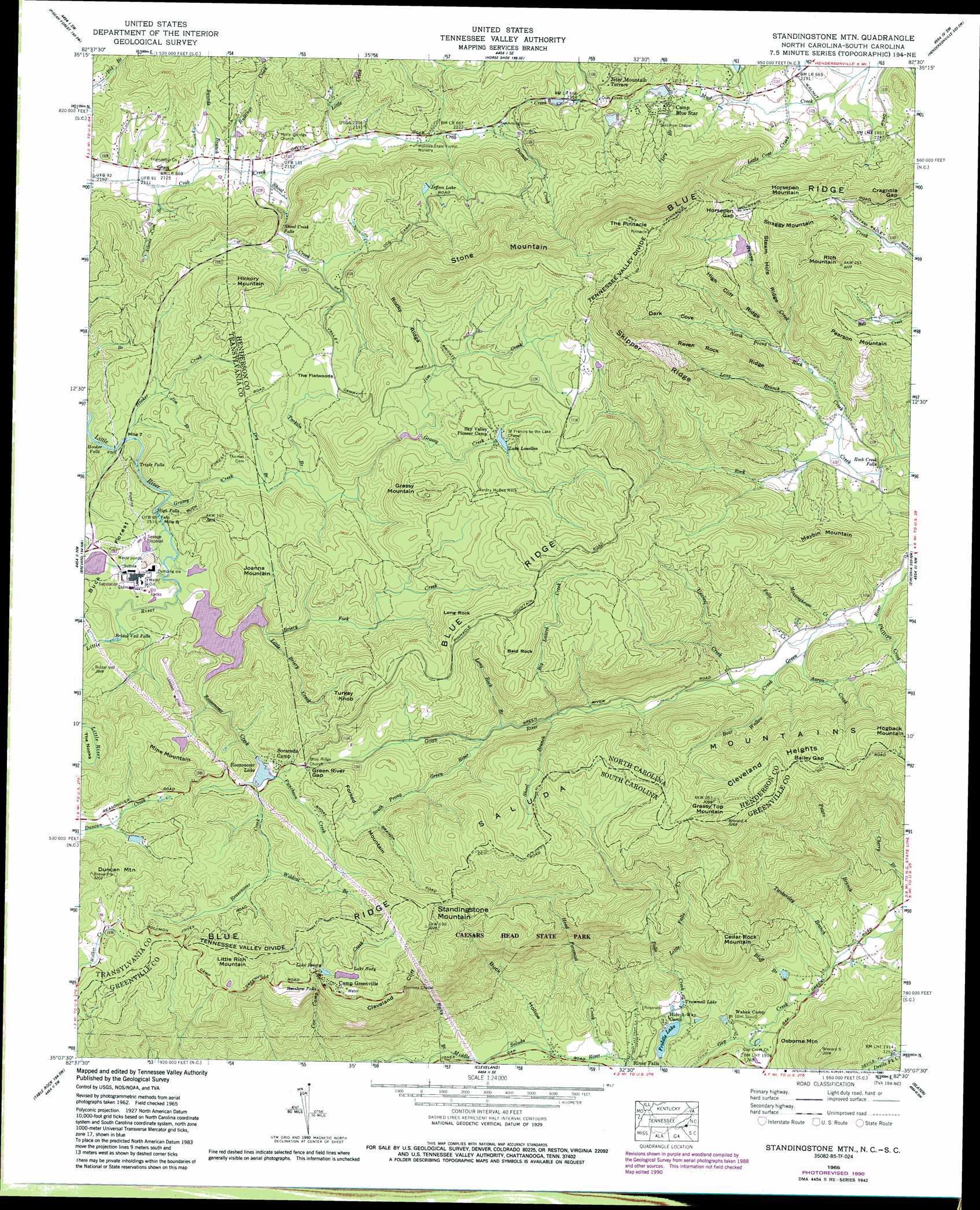
USGS Topo Quad 35082b5 - 1:24,000 scale
| Topo Map Name: | Standingstone Mountain |
| USGS Topo Quad ID: | 35082b5 |
| Print Size: | ca. 21 1/4" wide x 27" high |
| Southeast Coordinates: | 35.125° N latitude / 82.5° W longitude |
| Map Center Coordinates: | 35.1875° N latitude / 82.5625° W longitude |
| U.S. States: | NC, SC |
| Filename: | o35082b5.jpg |
| Download Map JPG Image: | Standingstone Mountain topo map 1:24,000 scale |
| Map Type: | Topographic |
| Topo Series: | 7.5´ |
| Map Scale: | 1:24,000 |
| Source of Map Images: | United States Geological Survey (USGS) |
| Alternate Map Versions: |
Standingstone Mtn. SC 1935 Download PDF Buy paper map Standingstone Mtn. SC 1946, updated 1947 Download PDF Buy paper map Standingstone Mtn. SC 1946, updated 1947 Download PDF Buy paper map Standingstone Mtn. SC 1946, updated 1964 Download PDF Buy paper map Standingstone Mtn. SC 1965, updated 1967 Download PDF Buy paper map Standingstone Mtn. SC 1965, updated 1974 Download PDF Buy paper map Standingstone Mtn. SC 1965, updated 1979 Download PDF Buy paper map Standingstone Mtn. SC 1965, updated 1991 Download PDF Buy paper map Standingstone Mtn. SC 1965, updated 1991 Download PDF Buy paper map Standingstone Mtn SC 1997, updated 2001 Download PDF Buy paper map Standingstone Mountain SC 2011 Download PDF Buy paper map Standingstone Mountain SC 2014 Download PDF Buy paper map |
1:24,000 Topo Quads surrounding Standingstone Mountain
Cruso |
Dunsmore Mountain |
Skyland |
Fruitland |
Bat Cave |
Shining Rock |
Pisgah Forest |
Horse Shoe |
Hendersonville |
Cliffield Mountain |
Rosman |
Brevard |
Standingstone Mountain |
Zirconia |
Saluda |
Eastatoe Gap |
Table Rock |
Cleveland |
Slater |
Tigerville |
Sunset |
Pickens |
Dacusville |
Paris Mountain |
Taylors |
> Back to 35082a1 at 1:100,000 scale
> Back to 35082a1 at 1:250,000 scale
> Back to U.S. Topo Maps home
Standingstone Mountain topo map: Gazetteer
Standingstone Mountain: Bends
The Nooks elevation 833m 2732′Standingstone Mountain: Cliffs
Cleveland Cliff elevation 847m 2778′Long Rock elevation 946m 3103′
Standingstone Mountain: Dams
Blue Star Lower Dam elevation 681m 2234′Blue Star Upper Dam elevation 718m 2355′
Dupont Dam elevation 781m 2562′
Reasonover Lake Dam elevation 826m 2709′
South Carolina Noname 23019 D-2828 Dam elevation 347m 1138′
Sudy Lake Dam D-2826 elevation 894m 2933′
Summit Camp Lake Lower Dam elevation 780m 2559′
Summit Camp Lake Upper Dam elevation 804m 2637′
Standingstone Mountain: Falls
Bridal Veil Falls elevation 791m 2595′High Falls elevation 737m 2417′
Hooker Falls elevation 679m 2227′
Rainbow Falls elevation 874m 2867′
Rock Creek Falls elevation 681m 2234′
Shoal Creek Falls elevation 692m 2270′
Triple Falls elevation 712m 2335′
Standingstone Mountain: Flats
The Flatwoods elevation 826m 2709′Standingstone Mountain: Gaps
Bailey Gap elevation 893m 2929′Cragnola Gap elevation 917m 3008′
Green River Gap elevation 828m 2716′
Horsepen Gap elevation 924m 3031′
Standingstone Mountain: Pillars
Vardry McBee Rock elevation 915m 3001′Standingstone Mountain: Populated Places
Jeter Mountain Terrace elevation 777m 2549′Standingstone Mountain: Ranges
Saluda Mountains elevation 992m 3254′Standingstone Mountain: Reservoirs
Blue Star Upper Lake elevation 718m 2355′Camp Blue Star Lake Number Two elevation 681m 2234′
Dupont Lake elevation 781m 2562′
Friddle Lake elevation 347m 1138′
Jeffers Lake elevation 762m 2500′
Lake Louellen elevation 887m 2910′
Lake Rotary elevation 888m 2913′
Lake Sudy elevation 894m 2933′
Reasonover Lake elevation 826m 2709′
Summit Camp Lake elevation 804m 2637′
Summit Lake elevation 780m 2559′
Trammell Lake elevation 360m 1181′
Standingstone Mountain: Ridges
Cleveland Heights elevation 924m 3031′High Cliff Ridge elevation 890m 2919′
Raven Rock Ridge elevation 895m 2936′
Rocky Ridge elevation 920m 3018′
Skipper Ridge elevation 1071m 3513′
Steam Hole Ridge elevation 930m 3051′
Standingstone Mountain: Streams
Aaron Creek elevation 642m 2106′Ailents Cove Branch elevation 642m 2106′
Bear Wallow Creek elevation 649m 2129′
Big Laurel Creek elevation 725m 2378′
Bluff Branch elevation 354m 1161′
Briery Fork Creek elevation 780m 2559′
Bullings Creek elevation 646m 2119′
Cherry Branch elevation 382m 1253′
Dismal Creek elevation 674m 2211′
Dry Branch elevation 757m 2483′
Dry Branch elevation 671m 2201′
Falls Creek elevation 642m 2106′
Grassy Creek elevation 731m 2398′
Hampy Creek elevation 724m 2375′
Head Foremost Creek elevation 342m 1122′
Hooker Creek elevation 688m 2257′
Jim Branch elevation 698m 2290′
Jim Creek elevation 859m 2818′
Little Briery Creek elevation 781m 2562′
Little Cove Creek elevation 661m 2168′
Little Creek elevation 655m 2148′
Little Falls Creek elevation 398m 1305′
Long Branch elevation 690m 2263′
Long Rock Branch elevation 759m 2490′
Meetinghouse Creek elevation 643m 2109′
North Prong Rock Creek elevation 686m 2250′
Peters Branch elevation 366m 1200′
Phillips Creek elevation 637m 2089′
Puncheon Creek elevation 810m 2657′
Reasonover Creek elevation 769m 2522′
Rocky Branch elevation 390m 1279′
Shoal Branch elevation 729m 2391′
Shoal Creek elevation 648m 2125′
South Prong Green River elevation 762m 2500′
Swords Branch elevation 645m 2116′
Tankersley Branch elevation 363m 1190′
Tarkiln Branch elevation 759m 2490′
Uncles Creek elevation 657m 2155′
Wildcat Branch elevation 822m 2696′
Standingstone Mountain: Summits
Bald Rock elevation 988m 3241′Cedar Rock Mountain elevation 696m 2283′
Duncan Mountain elevation 976m 3202′
Forked Mountain elevation 923m 3028′
Grassy Mountain elevation 988m 3241′
Grassy Top Mountain elevation 993m 3257′
Hickory Mountain elevation 916m 3005′
Hogback Mountain elevation 954m 3129′
Horsepen Mountain elevation 924m 3031′
Joanna Mountain elevation 883m 2896′
Little Rich Mountain elevation 1008m 3307′
Maybin Mountain elevation 906m 2972′
Mine Mountain elevation 941m 3087′
Osborne Mountain elevation 604m 1981′
Pearson Mountain elevation 919m 3015′
Rich Mountain elevation 998m 3274′
Snaggy Mountain elevation 1030m 3379′
Standingstone Mountain elevation 978m 3208′
Stone Mountain elevation 1095m 3592′
The Pinnacle elevation 1144m 3753′
Turkey Knob elevation 958m 3143′
Standingstone Mountain: Valleys
Buck Hollow elevation 361m 1184′Dark Cove elevation 762m 2500′
Standingstone Mountain digital topo map on disk
Buy this Standingstone Mountain topo map showing relief, roads, GPS coordinates and other geographical features, as a high-resolution digital map file on DVD:
South Carolina, Western North Carolina & Northeastern Georgia
Buy digital topo maps: South Carolina, Western North Carolina & Northeastern Georgia