Cleveland Topo Map South Carolina
To zoom in, hover over the map of Cleveland
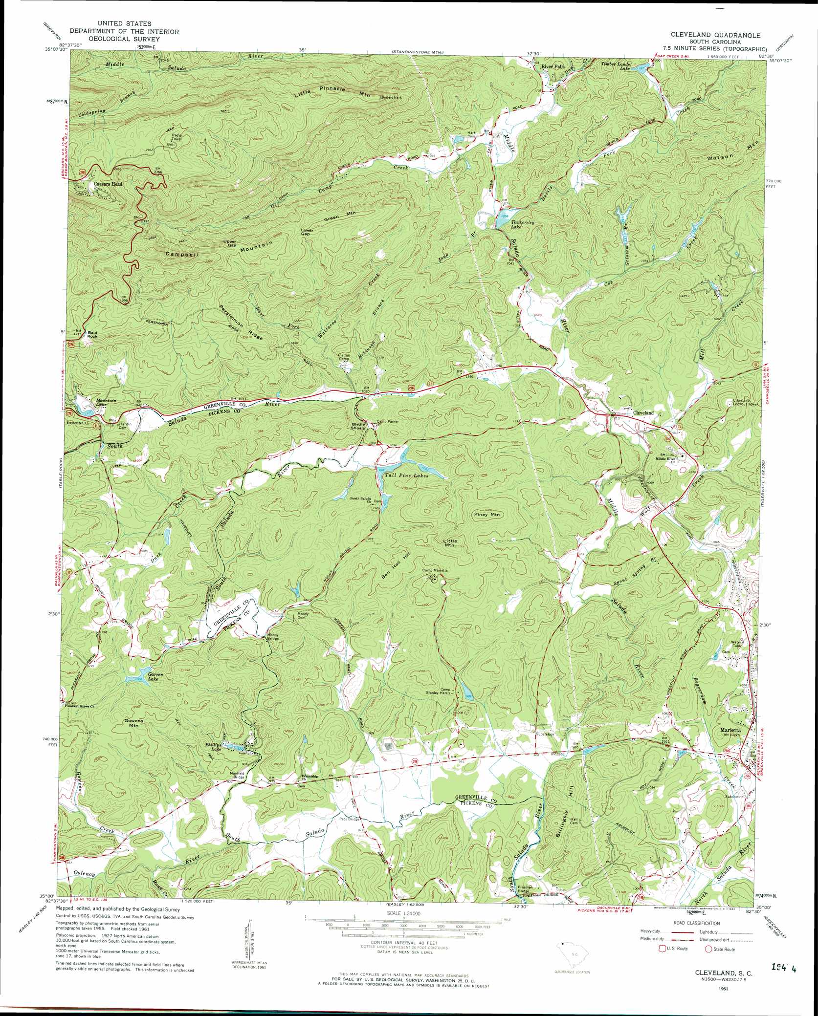
USGS Topo Quad 35082a5 - 1:24,000 scale
| Topo Map Name: | Cleveland |
| USGS Topo Quad ID: | 35082a5 |
| Print Size: | ca. 21 1/4" wide x 27" high |
| Southeast Coordinates: | 35° N latitude / 82.5° W longitude |
| Map Center Coordinates: | 35.0625° N latitude / 82.5625° W longitude |
| U.S. State: | SC |
| Filename: | o35082a5.jpg |
| Download Map JPG Image: | Cleveland topo map 1:24,000 scale |
| Map Type: | Topographic |
| Topo Series: | 7.5´ |
| Map Scale: | 1:24,000 |
| Source of Map Images: | United States Geological Survey (USGS) |
| Alternate Map Versions: |
Cleveland SC 1961, updated 1963 Download PDF Buy paper map Cleveland SC 1961, updated 1976 Download PDF Buy paper map Cleveland SC 2011 Download PDF Buy paper map Cleveland SC 2014 Download PDF Buy paper map |
1:24,000 Topo Quads surrounding Cleveland
Shining Rock |
Pisgah Forest |
Horse Shoe |
Hendersonville |
Cliffield Mountain |
Rosman |
Brevard |
Standingstone Mountain |
Zirconia |
Saluda |
Eastatoe Gap |
Table Rock |
Cleveland |
Slater |
Tigerville |
Sunset |
Pickens |
Dacusville |
Paris Mountain |
Taylors |
Six Mile |
Liberty |
Easley |
Greenville |
Mauldin |
> Back to 35082a1 at 1:100,000 scale
> Back to 35082a1 at 1:250,000 scale
> Back to U.S. Topo Maps home
Cleveland topo map: Gazetteer
Cleveland: Bridges
Freeman Bridge elevation 274m 898′Hardin Bridge elevation 319m 1046′
Mayfield Bridge elevation 280m 918′
Moody Bridge elevation 287m 941′
Pace Bridge elevation 274m 898′
Tally Bridge elevation 292m 958′
Cleveland: Dams
Camp Harris Pond Dam D-2832 elevation 299m 980′Ehlers Pond Dam D-1111 elevation 326m 1069′
F Bergman Pond Dam D-1106 elevation 310m 1017′
Garren Lake Dam D-2916 elevation 306m 1003′
Holiday Lake Dam D-2207 elevation 378m 1240′
Holly Pot Lake Dam D-2827 elevation 391m 1282′
Rice Pond Dam D-2831 elevation 349m 1145′
South Carolina Noname 23020 D-1095 Dam elevation 302m 990′
South Carolina Noname 23027 D-2830 Dam elevation 342m 1122′
Tankersley Lake Dam elevation 317m 1040′
Timber Lands Lake Dam D-2829 elevation 362m 1187′
Timmons Pond Dam D-2833 elevation 297m 974′
Wabac Pond Dam D-3296 elevation 356m 1167′
Cleveland: Gaps
Lower Gap elevation 574m 1883′Upper Gap elevation 626m 2053′
Cleveland: Parks
Caesars Head State Park elevation 923m 3028′Cleveland: Populated Places
Caesars Head elevation 957m 3139′Cleveland elevation 305m 1000′
Marietta elevation 305m 1000′
Mayfield (historical) elevation 291m 954′
Mountain Lake Colony elevation 352m 1154′
Olga (historical) elevation 326m 1069′
River Falls elevation 334m 1095′
Riverview elevation 322m 1056′
Wattacoo (historical) elevation 296m 971′
Cleveland: Post Offices
Caesars Head Post Office (historical) elevation 966m 3169′Cleveland: Rapids
Blythe Shoals elevation 301m 987′Cleveland: Reservoirs
Ehlers Pond elevation 326m 1069′Garren Lake elevation 306m 1003′
McDonalds Pond elevation 342m 1122′
Mountain Lake elevation 345m 1131′
Phillips Lake elevation 291m 954′
Rice Pond elevation 349m 1145′
Tall Pine Lakes elevation 302m 990′
Tankersley Lake elevation 317m 1040′
Timber Lands Lake elevation 362m 1187′
Timmons Pond elevation 297m 974′
Cleveland: Ridges
Persimmon Ridge elevation 479m 1571′Cleveland: Streams
Beaverdam Creek elevation 288m 944′Coldspring Branch elevation 609m 1998′
Cox Camp Creek elevation 475m 1558′
Cox Creek elevation 314m 1030′
Devils Fork Creek elevation 323m 1059′
Duck Creek elevation 292m 958′
Falls Creek elevation 335m 1099′
Gap Creek elevation 328m 1076′
Gowens Creek elevation 280m 918′
Grissom Branch elevation 324m 1062′
Hawk Creek elevation 280m 918′
Jane Branch elevation 316m 1036′
Middle Saluda River elevation 277m 908′
Mill Creek elevation 296m 971′
Oil Camp Creek elevation 320m 1049′
Oolenoy River elevation 280m 918′
Robinson Branch elevation 313m 1026′
Spout Spring Branch elevation 295m 967′
Wattacoo Creek elevation 312m 1023′
West Fork Wattacoo Creek elevation 331m 1085′
Wolf Creek elevation 298m 977′
Cleveland: Summits
Bald Rock elevation 524m 1719′Ben Hall Hill elevation 408m 1338′
Billingsly Hill elevation 361m 1184′
Campbell Mountain elevation 783m 2568′
Gowens Mountain elevation 379m 1243′
Green Mountain elevation 614m 2014′
Little Mountain elevation 475m 1558′
Little Pinnacle Mountain elevation 794m 2604′
Piney Mountain elevation 441m 1446′
Watson Mountain elevation 527m 1729′
Cleveland digital topo map on disk
Buy this Cleveland topo map showing relief, roads, GPS coordinates and other geographical features, as a high-resolution digital map file on DVD:
South Carolina, Western North Carolina & Northeastern Georgia
Buy digital topo maps: South Carolina, Western North Carolina & Northeastern Georgia