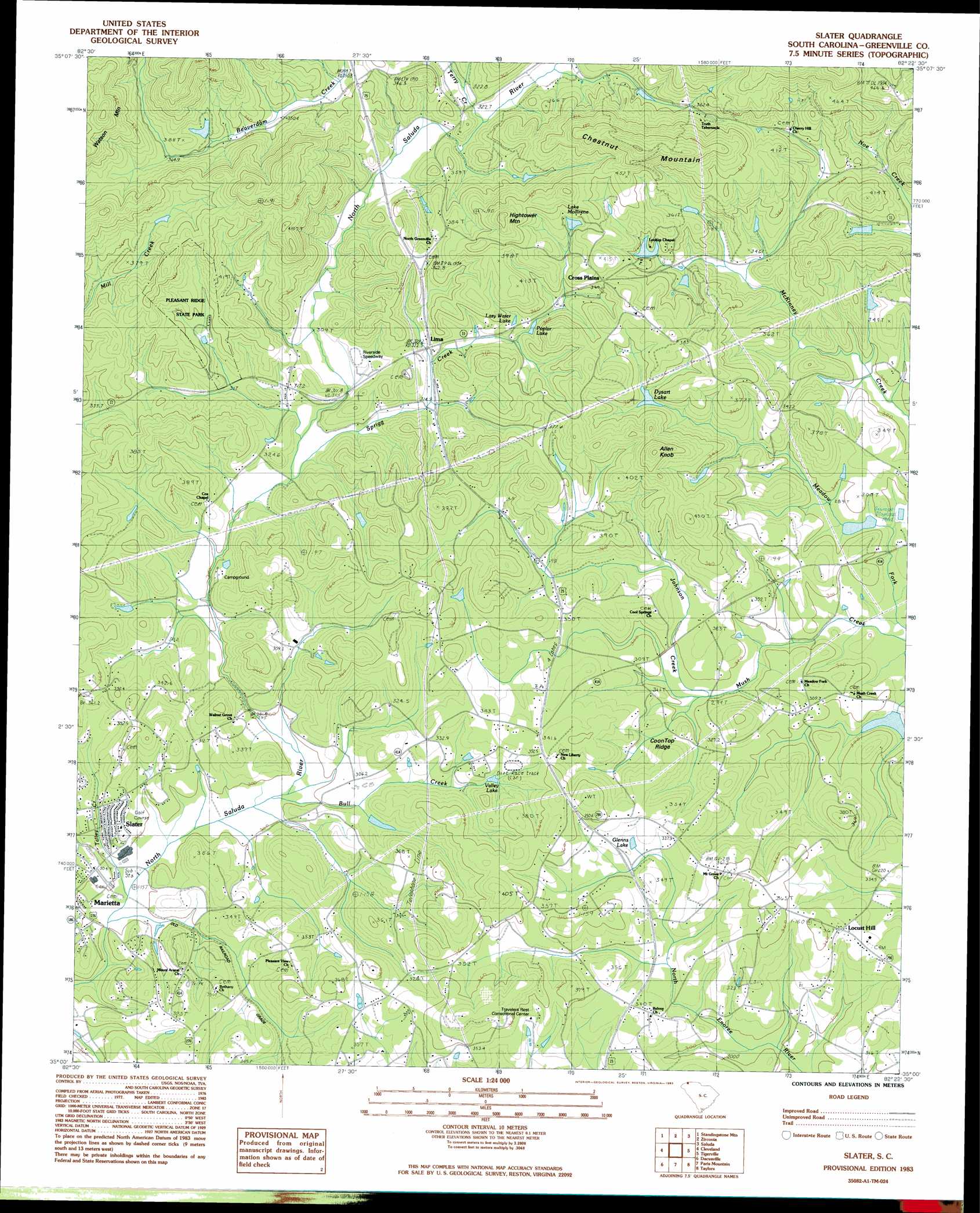
Slater Topo Map South Carolina
To zoom in, hover over the map of Slater
USGS Topo Quad 35082a4 - 1:24,000 scale
| Topo Map Name: | Slater |
| USGS Topo Quad ID: | 35082a4 |
| Print Size: | ca. 21 1/4" wide x 27" high |
| Southeast Coordinates: | 35° N latitude / 82.375° W longitude |
| Map Center Coordinates: | 35.0625° N latitude / 82.4375° W longitude |
| U.S. State: | SC |
| Filename: | o35082a4.jpg |
| Download Map JPG Image: | Slater topo map 1:24,000 scale |
| Map Type: | Topographic |
| Topo Series: | 7.5´ |
| Map Scale: | 1:24,000 |
| Source of Map Images: | United States Geological Survey (USGS) |
| Alternate Map Versions: |
Slater SC 1983, updated 1983 Download PDF Buy paper map Slater SC 1983, updated 1983 Download PDF Buy paper map Slater SC 2011 Download PDF Buy paper map Slater SC 2014 Download PDF Buy paper map |
1:24,000 Topo Quads surrounding Slater
Pisgah Forest |
Horse Shoe |
Hendersonville |
Cliffield Mountain |
Mill Spring |
Brevard |
Standingstone Mountain |
Zirconia |
Saluda |
Landrum |
Table Rock |
Cleveland |
Slater |
Tigerville |
Campobello |
Pickens |
Dacusville |
Paris Mountain |
Taylors |
Greer |
Liberty |
Easley |
Greenville |
Mauldin |
Pelham |
> Back to 35082a1 at 1:100,000 scale
> Back to 35082a1 at 1:250,000 scale
> Back to U.S. Topo Maps home
Slater topo map: Gazetteer
Slater: Airports
King Field elevation 402m 1318′Slater: Dams
Awanita Lake Dam D-2215 elevation 388m 1272′Beckydon Lake Dam elevation 351m 1151′
Belk Simpson Lake Dam D-2864 elevation 329m 1079′
C Fink Pond Dam D-2217 elevation 318m 1043′
Chinquapin Lake Dam elevation 343m 1125′
Douglas Ranch Pond Dam D-2838 elevation 313m 1026′
Dysart Lake Dam D-2851 elevation 345m 1131′
Forty Niner Lake Dam D-2852 elevation 358m 1174′
Howie Pond Dam D-1129 elevation 356m 1167′
J Stooksburry Pond Dam D-1121 elevation 344m 1128′
J Williams Pond Dam D-1173 elevation 387m 1269′
L A Hendricks Pond Dam elevation 363m 1190′
Lake Mollirene Dam D-1174 elevation 391m 1282′
McCarter Lake Dam D-1179 elevation 366m 1200′
N Morgan Pond Dam D-1172 elevation 362m 1187′
Rice Pond Dam D-1373 elevation 345m 1131′
S Huffman Pond Dam D-2834 elevation 330m 1082′
South Tyger River WCD Dam 2c D-2865 elevation 308m 1010′
Stevens Lake Dam D-2837 elevation 340m 1115′
Slater: Parks
Pleasant Ridge State Park elevation 357m 1171′Slater: Populated Places
Bellvue elevation 334m 1095′Cross Plains elevation 372m 1220′
Lima elevation 323m 1059′
Locust Hill elevation 346m 1135′
Marydell (historical) elevation 321m 1053′
Slater elevation 312m 1023′
Terry (historical) elevation 350m 1148′
Slater: Reservoirs
Beckydon Lake elevation 351m 1151′Chinquapin Lake elevation 338m 1108′
Dysart Lake elevation 345m 1131′
Glenns Lake elevation 321m 1053′
L A Hendricks Pond elevation 363m 1190′
Lake Chinquapin elevation 343m 1125′
Lake Francis elevation 326m 1069′
Lake Mollirene elevation 391m 1282′
Lazy Water Lake elevation 330m 1082′
Poplar Lake elevation 340m 1115′
Valley Lake elevation 322m 1056′
Slater: Ridges
Coon Top Ridge elevation 313m 1026′Slater: Streams
Bull Creek elevation 295m 967′Johnson Creek elevation 294m 964′
Mill Creek elevation 301m 987′
Short Branch elevation 321m 1053′
Sprigg Creek elevation 304m 997′
Talley Creek elevation 289m 948′
Terry Creek elevation 326m 1069′
Slater: Summits
Allen Knob elevation 455m 1492′Chestnut Mountain elevation 521m 1709′
Hightower Mountain elevation 476m 1561′
Slater digital topo map on disk
Buy this Slater topo map showing relief, roads, GPS coordinates and other geographical features, as a high-resolution digital map file on DVD:
South Carolina, Western North Carolina & Northeastern Georgia
Buy digital topo maps: South Carolina, Western North Carolina & Northeastern Georgia