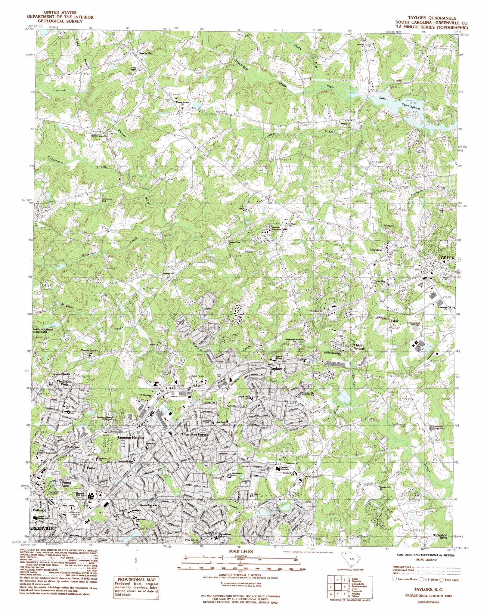
Taylors Topo Map South Carolina
To zoom in, hover over the map of Taylors
USGS Topo Quad 34082h3 - 1:24,000 scale
| Topo Map Name: | Taylors |
| USGS Topo Quad ID: | 34082h3 |
| Print Size: | ca. 21 1/4" wide x 27" high |
| Southeast Coordinates: | 34.875° N latitude / 82.25° W longitude |
| Map Center Coordinates: | 34.9375° N latitude / 82.3125° W longitude |
| U.S. State: | SC |
| Filename: | o34082h3.jpg |
| Download Map JPG Image: | Taylors topo map 1:24,000 scale |
| Map Type: | Topographic |
| Topo Series: | 7.5´ |
| Map Scale: | 1:24,000 |
| Source of Map Images: | United States Geological Survey (USGS) |
| Alternate Map Versions: |
Taylors SC 1983, updated 1983 Download PDF Buy paper map Taylors SC 2011 Download PDF Buy paper map Taylors SC 2014 Download PDF Buy paper map |
1:24,000 Topo Quads surrounding Taylors
Standingstone Mountain |
Zirconia |
Saluda |
Landrum |
Fingerville West |
Cleveland |
Slater |
Tigerville |
Campobello |
Inman |
Dacusville |
Paris Mountain |
Taylors |
Greer |
Wellford |
Easley |
Greenville |
Mauldin |
Pelham |
Reidville |
Piercetown |
Pelzer |
Simpsonville |
Fountain Inn |
Woodruff |
> Back to 34082e1 at 1:100,000 scale
> Back to 34082a1 at 1:250,000 scale
> Back to U.S. Topo Maps home
Taylors topo map: Gazetteer
Taylors: Dams
Batson Pond Dam D-2869 elevation 301m 987′Cardinal Lake Dam D-2871 elevation 313m 1026′
Lake Placid Dam D-1399 elevation 338m 1108′
South Carolina Noname 23002 Dam elevation 282m 925′
Taylors: Parks
East Riverside Park elevation 272m 892′Northside PArk elevation 301m 987′
Taylors: Populated Places
Bellwood Estates elevation 285m 935′Belmont Heights elevation 326m 1069′
Bird Fields elevation 296m 971′
Broadleaf Acres elevation 297m 974′
Broadmoor elevation 290m 951′
Brookwood Forest elevation 293m 961′
Burgiss Hills elevation 355m 1164′
Cane Brake elevation 274m 898′
Cannon Hills elevation 283m 928′
Cherokee Forest elevation 300m 984′
Chick Springs elevation 292m 958′
Colonial Hills elevation 282m 925′
Colony Subdivision elevation 313m 1026′
Creekside Villas elevation 287m 941′
Cunningham Acres elevation 278m 912′
Del Norte elevation 276m 905′
Del Norte Estates elevation 272m 892′
Dell Vista Heights elevation 333m 1092′
Dellwood elevation 310m 1017′
East Gate Village elevation 268m 879′
Edwards Forest Heights elevation 292m 958′
Enoree Hills elevation 263m 862′
Fairview elevation 341m 1118′
Forest View elevation 320m 1049′
Forestdale Heights elevation 288m 944′
Gilstrap Heights elevation 325m 1066′
Green Forest elevation 290m 951′
Green Hills elevation 306m 1003′
Grey Fox Run elevation 280m 918′
Groveland Dell elevation 291m 954′
Hampton Heights elevation 317m 1040′
Hermitage Hills elevation 300m 984′
Homestead Acres elevation 291m 954′
Jamestown Estates elevation 308m 1010′
King Acres elevation 305m 1000′
Kings (historical) elevation 316m 1036′
Kingsgate elevation 288m 944′
Laurel Hills elevation 313m 1026′
Liberty Park elevation 306m 1003′
Lorena Park elevation 292m 958′
McSwain Gardens elevation 302m 990′
Milford elevation 280m 918′
Minter elevation 318m 1043′
Morningside elevation 289m 948′
Mount Vernon Estates elevation 328m 1076′
North Acres elevation 327m 1072′
North Side Heights elevation 311m 1020′
Northwood elevation 284m 931′
Nursery (historical) elevation 302m 990′
Oak Hollow elevation 334m 1095′
Oak View elevation 276m 905′
Old Mill Estates elevation 289m 948′
Orchard Acres elevation 296m 971′
Paris elevation 327m 1072′
Pebble Creek elevation 287m 941′
Peppertree elevation 297m 974′
Piedmont Park elevation 331m 1085′
Pine Knott Forest elevation 319m 1046′
Pinehaven Acres elevation 300m 984′
Pinewood Estates elevation 287m 941′
Piney Ridge elevation 306m 1003′
Riverdowns elevation 267m 875′
Rosedale elevation 275m 902′
Sandy Flat elevation 316m 1036′
Seven Oaks elevation 291m 954′
Shady Creek elevation 315m 1033′
Silver Leaf elevation 284m 931′
Spring Forest elevation 297m 974′
Stone Lake Heights elevation 305m 1000′
Suber elevation 296m 971′
Sugar Creek elevation 279m 915′
Sugar Creek Villas elevation 291m 954′
Sugar Mill elevation 273m 895′
Sylvan Hills elevation 321m 1053′
Taylors elevation 284m 931′
The Meadows elevation 296m 971′
Thornwood elevation 298m 977′
Thornwood Acres elevation 288m 944′
Totany Woods elevation 301m 987′
Valley Haven elevation 274m 898′
Wade Hampton elevation 314m 1030′
Wade Hampton Gardens elevation 310m 1017′
Walden Pond elevation 293m 961′
White Oak elevation 318m 1043′
Wildaire elevation 298m 977′
Willington Green elevation 281m 921′
Willow Heights elevation 326m 1069′
Windsor Oaks elevation 279m 915′
Taylors: Post Offices
Taylors Post Office elevation 289m 948′Taylors: Reservoirs
Batson Pond elevation 301m 987′Cardinal Lake elevation 313m 1026′
Johnson Lake elevation 317m 1040′
Lake Cunningham elevation 282m 925′
Lake Placid elevation 338m 1108′
Taylors: Streams
Beaverdam Creek elevation 268m 879′Beaverdam Creek elevation 280m 918′
Buckhorn Creek elevation 275m 902′
Cane Creek elevation 256m 839′
Clear Creek elevation 256m 839′
Enoree Fork Branch elevation 255m 836′
Long Branch elevation 296m 971′
Mountain Creek elevation 272m 892′
Taylors digital topo map on disk
Buy this Taylors topo map showing relief, roads, GPS coordinates and other geographical features, as a high-resolution digital map file on DVD:
South Carolina, Western North Carolina & Northeastern Georgia
Buy digital topo maps: South Carolina, Western North Carolina & Northeastern Georgia