Shining Rock Topo Map North Carolina
To zoom in, hover over the map of Shining Rock
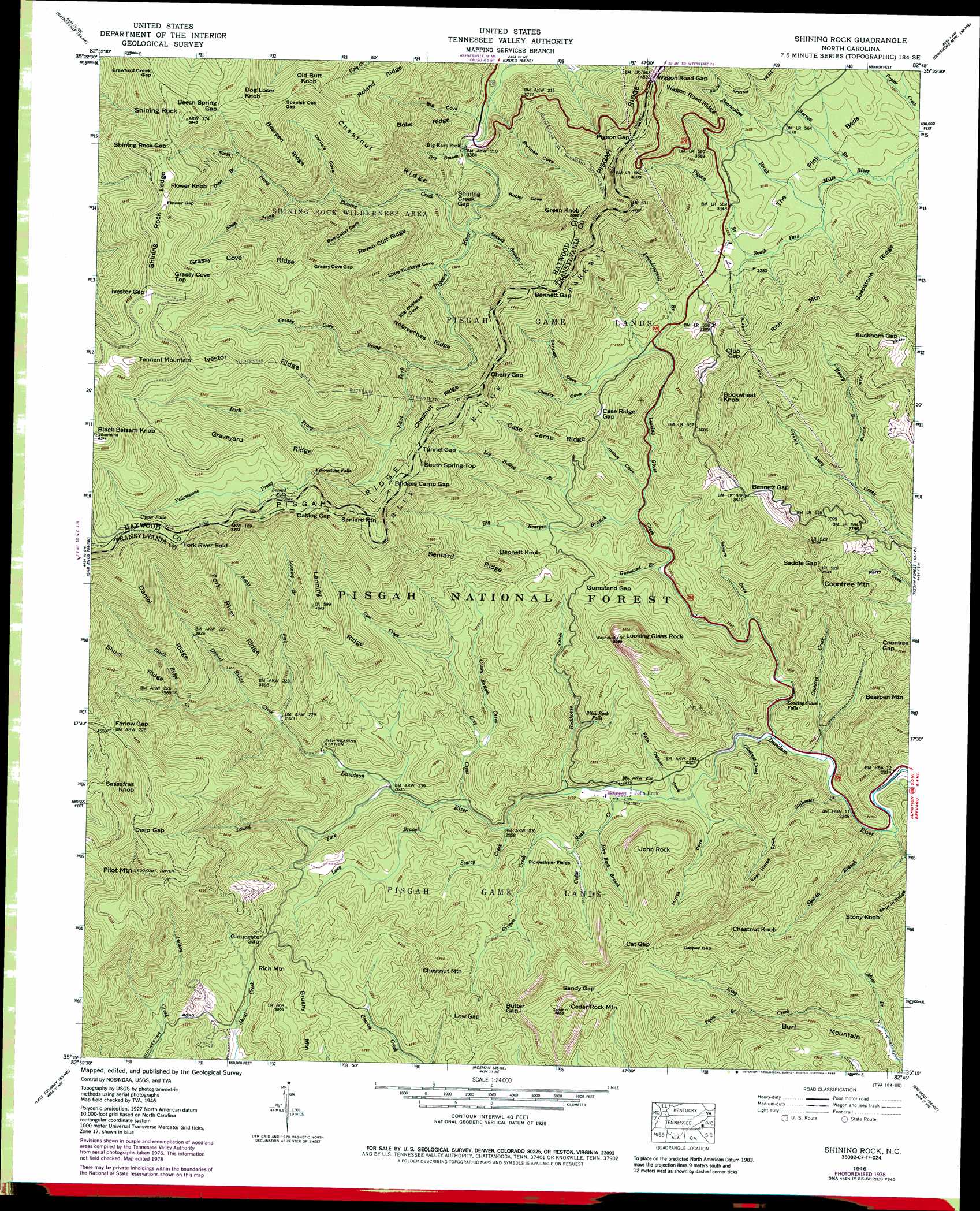
USGS Topo Quad 35082c7 - 1:24,000 scale
| Topo Map Name: | Shining Rock |
| USGS Topo Quad ID: | 35082c7 |
| Print Size: | ca. 21 1/4" wide x 27" high |
| Southeast Coordinates: | 35.25° N latitude / 82.75° W longitude |
| Map Center Coordinates: | 35.3125° N latitude / 82.8125° W longitude |
| U.S. State: | NC |
| Filename: | o35082c7.jpg |
| Download Map JPG Image: | Shining Rock topo map 1:24,000 scale |
| Map Type: | Topographic |
| Topo Series: | 7.5´ |
| Map Scale: | 1:24,000 |
| Source of Map Images: | United States Geological Survey (USGS) |
| Alternate Map Versions: |
Shining Rock NC 1935 Download PDF Buy paper map Shining Rock NC 1946, updated 1947 Download PDF Buy paper map Shining Rock NC 1946, updated 1947 Download PDF Buy paper map Shining Rock NC 1946, updated 1956 Download PDF Buy paper map Shining Rock NC 1946, updated 1965 Download PDF Buy paper map Shining Rock NC 1946, updated 1970 Download PDF Buy paper map Shining Rock NC 1946, updated 1978 Download PDF Buy paper map Shining Rock NC 1946, updated 1988 Download PDF Buy paper map Shining Rock NC 1997, updated 2001 Download PDF Buy paper map Shining Rock NC 2011 Download PDF Buy paper map Shining Rock NC 2013 Download PDF Buy paper map Shining Rock NC 2016 Download PDF Buy paper map |
| FStopo: | US Forest Service topo Shining Rock is available: Download FStopo PDF Download FStopo TIF |
1:24,000 Topo Quads surrounding Shining Rock
Dellwood |
Clyde |
Canton |
Enka |
Asheville |
Hazelwood |
Waynesville |
Cruso |
Dunsmore Mountain |
Skyland |
Tuckasegee |
Sam Knob |
Shining Rock |
Pisgah Forest |
Horse Shoe |
Big Ridge |
Lake Toxaway |
Rosman |
Brevard |
Standingstone Mountain |
Cashiers |
Reid |
Eastatoe Gap |
Table Rock |
Cleveland |
> Back to 35082a1 at 1:100,000 scale
> Back to 35082a1 at 1:250,000 scale
> Back to U.S. Topo Maps home
Shining Rock topo map: Gazetteer
Shining Rock: Falls
Looking Glass Falls elevation 720m 2362′Second Falls elevation 1494m 4901′
Slick Rock Falls elevation 817m 2680′
Upper Falls elevation 1630m 5347′
Yellowstone Falls elevation 1460m 4790′
Shining Rock: Flats
The Pink Beds elevation 1011m 3316′Shining Rock: Gaps
Beech Spring Gap elevation 1714m 5623′Bennett Gap elevation 1068m 3503′
Bennett Gap elevation 1343m 4406′
Bridges Camp Gap elevation 1370m 4494′
Buckhorn Gap elevation 1085m 3559′
Butter Gap elevation 1030m 3379′
Case Ridge Gap elevation 1020m 3346′
Cat Gap elevation 1020m 3346′
Catpen Gap elevation 1080m 3543′
Cherry Gap elevation 1317m 4320′
Club Gap elevation 1152m 3779′
Coontree Gap elevation 887m 2910′
Crawford Creek Gap elevation 1755m 5757′
Deep Gap elevation 1393m 4570′
Farlow Gap elevation 1387m 4550′
Flower Gap elevation 1764m 5787′
Gloucester Gap elevation 990m 3248′
Grassy Cove Gap elevation 1562m 5124′
Gumstand Gap elevation 939m 3080′
Ivestor Gap elevation 1734m 5688′
Low Gap elevation 984m 3228′
Oaklog Gap elevation 1524m 5000′
Pigeon Gap elevation 1379m 4524′
Saddle Gap elevation 1013m 3323′
Sandy Gap elevation 1105m 3625′
Shining Creek Gap elevation 1119m 3671′
Shining Rock Gap elevation 1757m 5764′
Spanish Oak Gap elevation 1632m 5354′
Tunnel Gap elevation 1368m 4488′
Wagon Road Gap elevation 1380m 4527′
Shining Rock: Parks
Cradle of Forestry in America elevation 1019m 3343′Shining Rock: Populated Places
Big East Fork elevation 1048m 3438′Shining Rock: Ridges
Bearpen Ridge elevation 1642m 5387′Bobs Ridge elevation 1344m 4409′
Case Camp Ridge elevation 1128m 3700′
Chestnut Ridge elevation 1443m 4734′
Chestnut Ridge elevation 1485m 4872′
Daniel Ridge elevation 1369m 4491′
Fork River Ridge elevation 1335m 4379′
Grassy Cove Ridge elevation 1618m 5308′
Graveyard Ridge elevation 1605m 5265′
Ivestor Ridge elevation 1627m 5337′
Lanning Ridge elevation 1233m 4045′
Nobreechies Ridge elevation 1350m 4429′
Picklesimer Fields elevation 794m 2604′
Pisgah Ridge elevation 1416m 4645′
Raven Cliff Ridge elevation 1439m 4721′
Seniard Ridge elevation 1060m 3477′
Shining Rock Ledge elevation 1751m 5744′
Shuck Ridge elevation 1522m 4993′
Soapstone Ridge elevation 1128m 3700′
Wagon Road Ridge elevation 1252m 4107′
Shining Rock: Streams
Barnett Branch elevation 971m 3185′Bearwallow Brook elevation 974m 3195′
Bennett Branch elevation 1062m 3484′
Big Bearpen Branch elevation 862m 2828′
Caney Bottom Creek elevation 815m 2673′
Cedar Rock Creek elevation 711m 2332′
Chestnut Creek elevation 694m 2276′
Coontree Creek elevation 686m 2250′
Cove Creek elevation 771m 2529′
Daniel Ridge Creek elevation 882m 2893′
Dark Prong elevation 1277m 4189′
Dina Branch elevation 1449m 4753′
Dry Branch elevation 1036m 3398′
Fawn Branch elevation 850m 2788′
Greasy Cove Prong elevation 1207m 3959′
Grogan Creek elevation 790m 2591′
Gumstand Branch elevation 826m 2709′
Henry Branch elevation 781m 2562′
John Rock Branch elevation 727m 2385′
Lanning Branch elevation 1060m 3477′
Laurel Fork elevation 801m 2627′
Log Hollow Branch elevation 873m 2864′
Long Branch elevation 784m 2572′
Looking Glass Creek elevation 693m 2273′
Mine Branch elevation 721m 2365′
North Prong Shining Creek elevation 1309m 4294′
Pigeon Branch elevation 988m 3241′
Poundingmill Branch elevation 942m 3090′
Right Fork Davidson River elevation 882m 2893′
Rockhouse Creek elevation 721m 2365′
Searcy Creek elevation 750m 2460′
Shining Creek elevation 1059m 3474′
Shuck Ridge Creek elevation 919m 3015′
Shut-in Branch elevation 677m 2221′
South Prong Shining Creek elevation 1309m 4294′
Stillwater Branch elevation 682m 2237′
Yellowstone Prong elevation 1277m 4189′
Shining Rock: Summits
Bennett Knob elevation 1101m 3612′Black Balsam Knob elevation 1892m 6207′
Brushy Mountain elevation 1082m 3549′
Buckwheat Knob elevation 1220m 4002′
Burl Mountain elevation 1067m 3500′
Cedar Rock Mountain elevation 1236m 4055′
Chestnut Knob elevation 1172m 3845′
Chestnut Mountain elevation 1127m 3697′
Coontree Mountain elevation 1057m 3467′
Dog Loser Knob elevation 1748m 5734′
Flower Knob elevation 1796m 5892′
Fork River Bald elevation 1679m 5508′
Grassy Cove Top elevation 1840m 6036′
Green Knob elevation 1535m 5036′
John Rock elevation 975m 3198′
Looking Glass Rock elevation 1208m 3963′
Old Butt Knob elevation 1683m 5521′
Pilot Mountain elevation 1541m 5055′
Rich Mountain elevation 1237m 4058′
Rich Mountain elevation 1085m 3559′
Sassafras Knob elevation 1507m 4944′
Seniard Mountain elevation 1537m 5042′
Shining Rock elevation 1821m 5974′
South Spring Top elevation 1398m 4586′
Stony Knob elevation 997m 3270′
Tennent Mountain elevation 1848m 6062′
Shining Rock: Trails
Art Loeb Trail elevation 1355m 4445′Shining Rock: Valleys
Bell Collar Cove elevation 1175m 3854′Bennett Cove elevation 966m 3169′
Big Buckeye Cove elevation 1107m 3631′
Big Cove elevation 1007m 3303′
Bullpen Cove elevation 1004m 3293′
Cherry Cove elevation 966m 3169′
Daniels Cove elevation 1232m 4041′
East Horse Cove elevation 717m 2352′
Fate Osteen Cove elevation 706m 2316′
Horse Cove elevation 705m 2312′
Justus Cove elevation 873m 2864′
Little Buckeye Cove elevation 1082m 3549′
Moore Cove elevation 739m 2424′
Rocky Cove elevation 1041m 3415′
Shining Rock digital topo map on disk
Buy this Shining Rock topo map showing relief, roads, GPS coordinates and other geographical features, as a high-resolution digital map file on DVD:
South Carolina, Western North Carolina & Northeastern Georgia
Buy digital topo maps: South Carolina, Western North Carolina & Northeastern Georgia