Lois Topo Map Tennessee
To zoom in, hover over the map of Lois
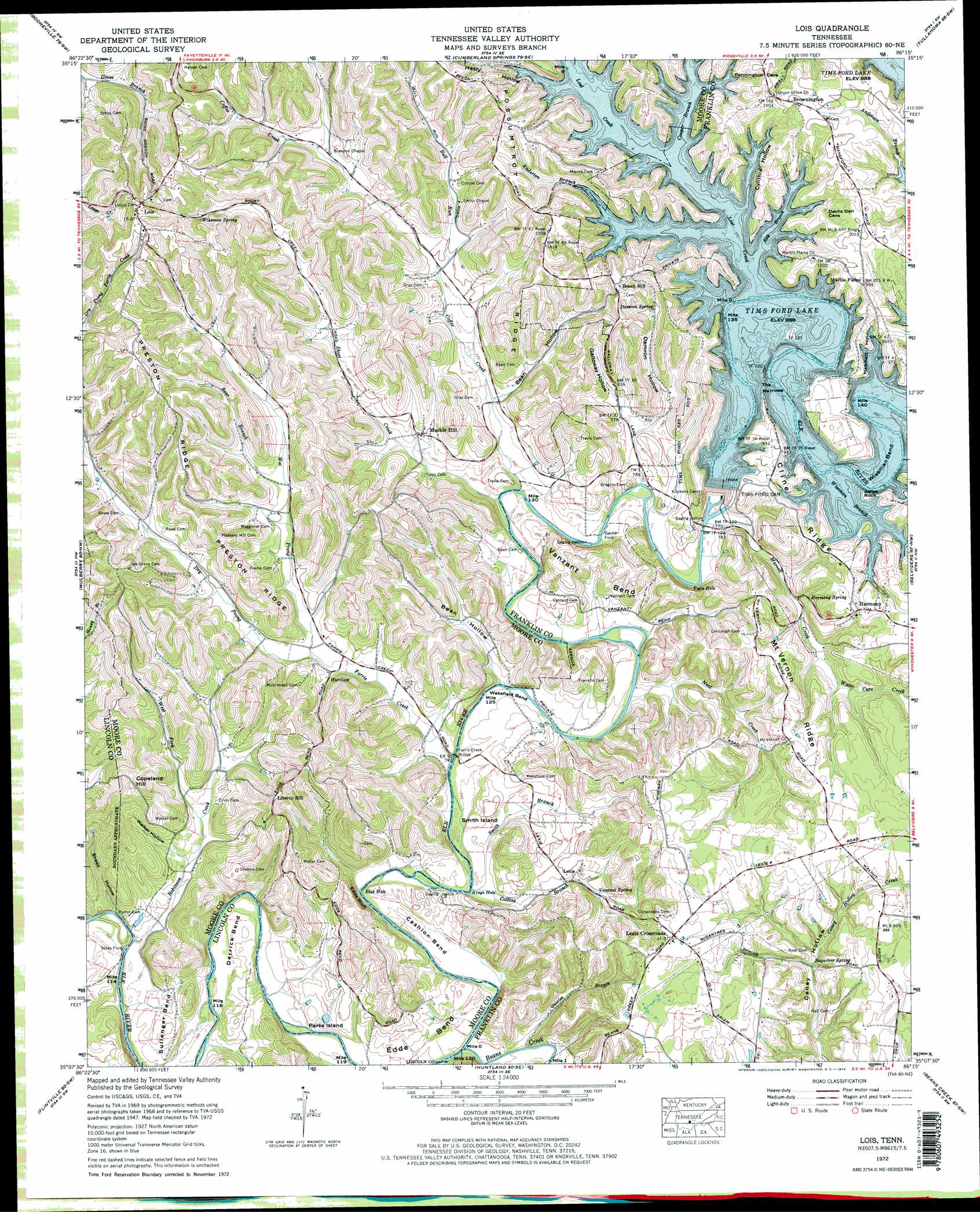
USGS Topo Quad 35086b3 - 1:24,000 scale
| Topo Map Name: | Lois |
| USGS Topo Quad ID: | 35086b3 |
| Print Size: | ca. 21 1/4" wide x 27" high |
| Southeast Coordinates: | 35.125° N latitude / 86.25° W longitude |
| Map Center Coordinates: | 35.1875° N latitude / 86.3125° W longitude |
| U.S. State: | TN |
| Filename: | o35086b3.jpg |
| Download Map JPG Image: | Lois topo map 1:24,000 scale |
| Map Type: | Topographic |
| Topo Series: | 7.5´ |
| Map Scale: | 1:24,000 |
| Source of Map Images: | United States Geological Survey (USGS) |
| Alternate Map Versions: |
Lois TN 1936 Download PDF Buy paper map Lois TN 1947, updated 1948 Download PDF Buy paper map Lois TN 1947, updated 1964 Download PDF Buy paper map Lois TN 1972, updated 1973 Download PDF Buy paper map Lois TN 1972, updated 1973 Download PDF Buy paper map Lois TN 2010 Download PDF Buy paper map Lois TN 2013 Download PDF Buy paper map Lois TN 2016 Download PDF Buy paper map |
1:24,000 Topo Quads surrounding Lois
Bedford |
Shelbyville |
Normandy |
Normandy Lake |
Manchester |
Belleville |
Lynchburg West |
Lynchburg East |
Tullahoma |
Capitol Hill |
Fayetteville |
Mulberry |
Lois |
Belvidere |
Winchester |
Lincoln |
Flintville |
Huntland |
Beans Creek |
Pitcher Ridge |
Fisk |
New Market |
King Cove |
Estill Fork |
Hytop |
> Back to 35086a1 at 1:100,000 scale
> Back to 35086a1 at 1:250,000 scale
> Back to U.S. Topo Maps home
Lois topo map: Gazetteer
Lois: Bends
Cashion Bend elevation 222m 728′Derrick Bend elevation 223m 731′
Edde Bend elevation 227m 744′
Sullenger Bend elevation 232m 761′
Vanzant Bend elevation 239m 784′
Wakefield Bend elevation 224m 734′
Wiseman Bend elevation 271m 889′
Wiseman Bend elevation 223m 731′
Lois: Bridges
Farris Creek Bridge elevation 221m 725′Tims Ford Bridges elevation 230m 754′
Lois: Capes
Jollys Rock elevation 275m 902′Lois: Cliffs
Edde Bluff elevation 252m 826′Lois: Crossings
Garner Ford elevation 226m 741′Stiles Ford elevation 212m 695′
Lois: Dams
Tims Ford Dam elevation 271m 889′Lois: Flats
Smith Island elevation 237m 777′Lois: Gaps
The Narrows elevation 271m 889′Lois: Islands
Parks Island elevation 233m 764′Lois: Lakes
Blue Hole elevation 218m 715′Kings Hole elevation 220m 721′
Turn Hole elevation 230m 754′
Lois: Parks
Anderton Branch Public Use Area elevation 274m 898′Lois: Populated Places
Beech Hill elevation 315m 1033′Brownington elevation 306m 1003′
Hurdlow elevation 230m 754′
Lexie elevation 237m 777′
Lexie Crossroads elevation 298m 977′
Liberty Hill elevation 309m 1013′
Lois elevation 334m 1095′
Marble Hill elevation 240m 787′
Lois: Reservoirs
Tims Ford Lake elevation 271m 889′Lois: Ridges
Cashion Ridge elevation 292m 958′Cline Ridge elevation 283m 928′
Mount Vernon Ridge elevation 283m 928′
Possumtrot Ridge elevation 318m 1043′
Reston Ridge elevation 313m 1026′
Lois: Springs
Damron Spring elevation 270m 885′Harmony Spring elevation 253m 830′
Sugartree Spring elevation 252m 826′
Vanzant Spring elevation 242m 793′
Wiseman Spring elevation 310m 1017′
Lois: Streams
Anderton Branch elevation 271m 889′Beans Creek elevation 217m 711′
Bear Branch elevation 247m 810′
Bull Run elevation 241m 790′
Coffee Creek elevation 225m 738′
Collins Branch elevation 220m 721′
Cooper Branch elevation 271m 889′
Dry Prong Farris Creek elevation 287m 941′
Farris Creek elevation 222m 728′
Lost Creek elevation 271m 889′
Murrell Creek elevation 230m 754′
Neal Creek elevation 223m 731′
Quarles Branch elevation 220m 721′
Ray Branch elevation 271m 889′
Robinson Creek elevation 213m 698′
Short Creek elevation 225m 738′
Smith Branch elevation 221m 725′
Templeton Branch elevation 220m 721′
Water Cure Creek elevation 248m 813′
West Fork Robinson Creek elevation 227m 744′
Wet Prong Farris Creek elevation 231m 757′
Wiseman Branch elevation 271m 889′
Lois: Summits
Copeland Hill elevation 303m 994′Lois: Valleys
Bean Hollow elevation 222m 728′Bean Hollow elevation 234m 767′
Cynthia Hollow elevation 271m 889′
Damron Hollow elevation 240m 787′
Galloway Hollow elevation 239m 784′
Hasty Hollow elevation 271m 889′
Hatchett Hollow elevation 271m 889′
Sheep Hollow elevation 212m 695′
Tripp Hollow elevation 231m 757′
Wagoner Hollow elevation 247m 810′
Walker Hollow elevation 227m 744′
Lois digital topo map on disk
Buy this Lois topo map showing relief, roads, GPS coordinates and other geographical features, as a high-resolution digital map file on DVD: