Jeanette Topo Map Arkansas
To zoom in, hover over the map of Jeanette
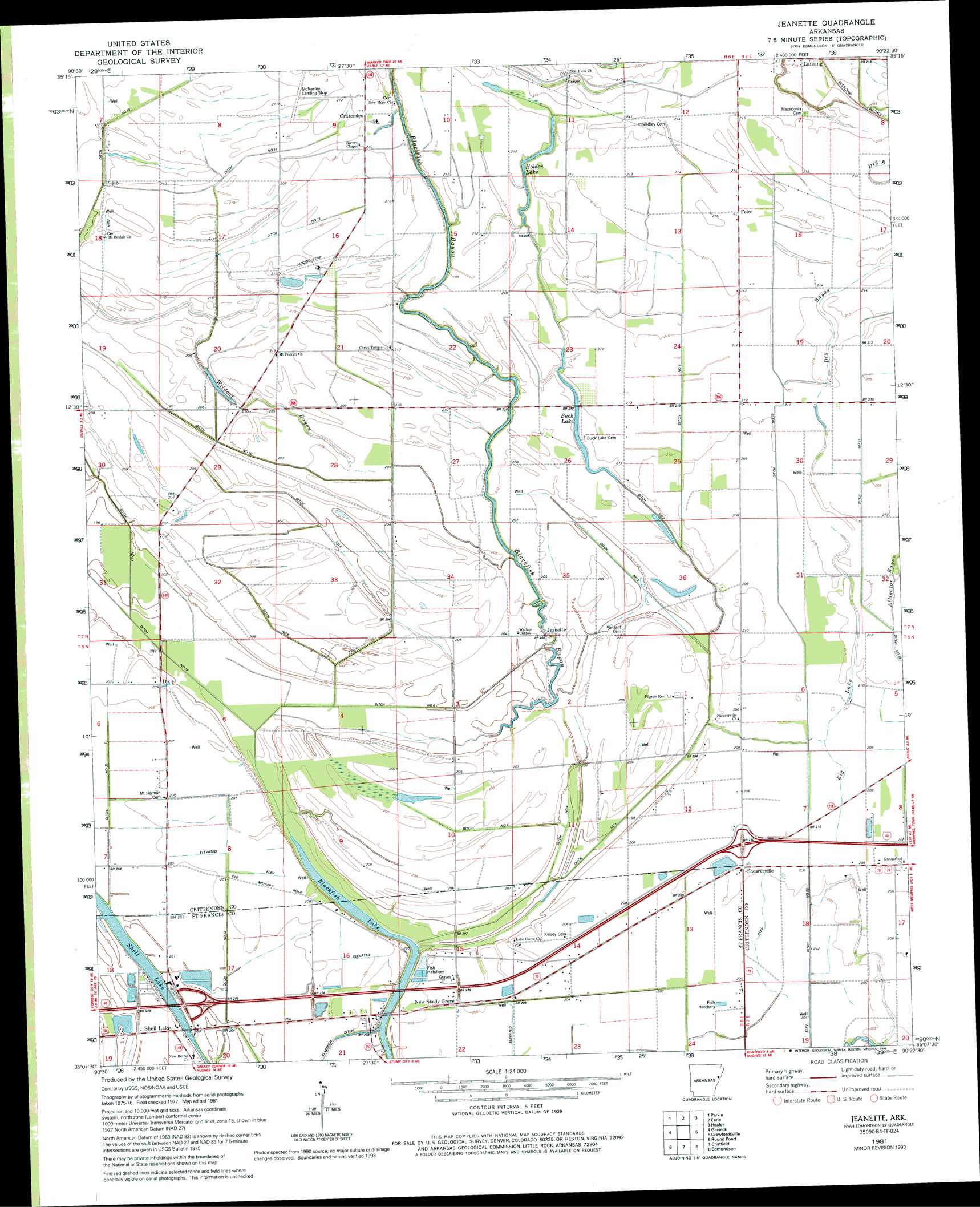
USGS Topo Quad 35090b4 - 1:24,000 scale
| Topo Map Name: | Jeanette |
| USGS Topo Quad ID: | 35090b4 |
| Print Size: | ca. 21 1/4" wide x 27" high |
| Southeast Coordinates: | 35.125° N latitude / 90.375° W longitude |
| Map Center Coordinates: | 35.1875° N latitude / 90.4375° W longitude |
| U.S. State: | AR |
| Filename: | o35090b4.jpg |
| Download Map JPG Image: | Jeanette topo map 1:24,000 scale |
| Map Type: | Topographic |
| Topo Series: | 7.5´ |
| Map Scale: | 1:24,000 |
| Source of Map Images: | United States Geological Survey (USGS) |
| Alternate Map Versions: |
Edmondson NW AR 1975, updated 1976 Download PDF Buy paper map Jeanette AR 1981, updated 1982 Download PDF Buy paper map Jeanette AR 1981, updated 1993 Download PDF Buy paper map Jeanette AR 2011 Download PDF Buy paper map Jeanette AR 2014 Download PDF Buy paper map |
1:24,000 Topo Quads surrounding Jeanette
Cherry Valley East |
Monterey |
Joyland |
Tyronza |
Frenchmans Bayou |
Princedale |
Parkin |
Earle |
Heafer |
Jericho |
Wittsburg |
Gieseck |
Jeanette |
Crawfordsville |
West Memphis |
Madison |
Round Pond |
Chatfield |
Edmondson |
Fletcher Lake |
Dansby |
Mud Lake |
Hughes |
Horseshoe Lake |
Lake Cormorant |
> Back to 35090a1 at 1:100,000 scale
> Back to 35090a1 at 1:250,000 scale
> Back to U.S. Topo Maps home
Jeanette topo map: Gazetteer
Jeanette: Airports
Bernard Manor Airport elevation 64m 209′Jeanette: Canals
Ditch Number 1 elevation 60m 196′Ditch Number 1 elevation 64m 209′
Ditch Number 10 elevation 63m 206′
Ditch Number 11 elevation 63m 206′
Ditch Number 12 elevation 62m 203′
Ditch Number 13 elevation 63m 206′
Ditch Number 16 elevation 57m 187′
Ditch Number 2 elevation 63m 206′
Ditch Number 20 elevation 62m 203′
Ditch Number 21 elevation 64m 209′
Ditch Number 22 elevation 61m 200′
Ditch Number 23 elevation 62m 203′
Ditch Number 4 elevation 61m 200′
Ditch Number 5 elevation 61m 200′
Ditch Number 6 elevation 57m 187′
Ditch Number 8 elevation 59m 193′
Ditch Number 9 elevation 61m 200′
Jeanette: Crossings
Interchange 260 elevation 62m 203′Interchange 265 elevation 64m 209′
Jeanette: Flats
Big Lake elevation 63m 206′Jeanette: Lakes
Blackfish Lake elevation 58m 190′Buck Lake elevation 61m 200′
Holden Lake elevation 65m 213′
Shell Lake elevation 61m 200′
Jeanette: Populated Places
Crittenden elevation 64m 209′Dixie elevation 62m 203′
Felco elevation 66m 216′
Jeanette elevation 58m 190′
Jennette elevation 62m 203′
New Shady Grove elevation 62m 203′
Shearerville elevation 64m 209′
Shell Lake elevation 61m 200′
Wildcat (historical) elevation 65m 213′
Jeanette: Streams
Dry Bayou elevation 65m 213′Jeka Slough elevation 62m 203′
Wildcat Bayou elevation 61m 200′
Jeanette digital topo map on disk
Buy this Jeanette topo map showing relief, roads, GPS coordinates and other geographical features, as a high-resolution digital map file on DVD: