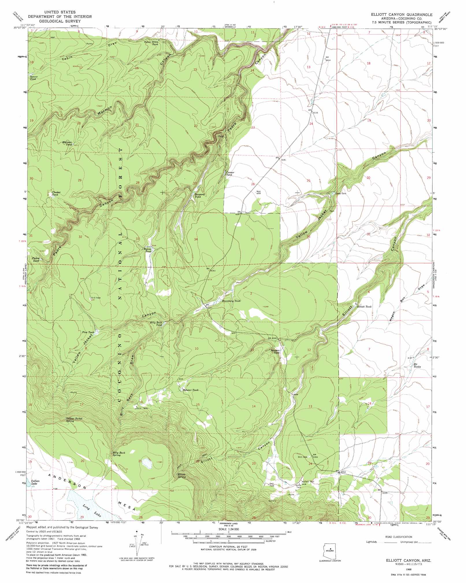
Elliott Canyon Topo Map Arizona
To zoom in, hover over the map of Elliott Canyon
USGS Topo Quad 35111a3 - 1:24,000 scale
| Topo Map Name: | Elliott Canyon |
| USGS Topo Quad ID: | 35111a3 |
| Print Size: | ca. 21 1/4" wide x 27" high |
| Southeast Coordinates: | 35° N latitude / 111.25° W longitude |
| Map Center Coordinates: | 35.0625° N latitude / 111.3125° W longitude |
| U.S. State: | AZ |
| Filename: | o35111a3.jpg |
| Download Map JPG Image: | Elliott Canyon topo map 1:24,000 scale |
| Map Type: | Topographic |
| Topo Series: | 7.5´ |
| Map Scale: | 1:24,000 |
| Source of Map Images: | United States Geological Survey (USGS) |
| Alternate Map Versions: |
Elliott Canyon AZ 1968, updated 1971 Download PDF Buy paper map Elliott Canyon AZ 1968, updated 1981 Download PDF Buy paper map Elliott Canyon AZ 1968, updated 1981 Download PDF Buy paper map Elliott Canyon AZ 2011 Download PDF Buy paper map Elliott Canyon AZ 2014 Download PDF Buy paper map |
| FStopo: | US Forest Service topo Elliott Canyon is available: Download FStopo PDF Download FStopo TIF |
1:24,000 Topo Quads surrounding Elliott Canyon
Sunset Crater West |
Sunset Crater East |
Merriam Crater |
Grand Falls Sw |
Grand Falls Se |
Flagstaff East |
Winona |
Angell |
Babbitt Wash |
Canyon Diablo |
Lower Lake Mary |
Ashurst Lake |
Elliott Canyon |
Anderson Canyon |
Meteor Crater |
Mormon Mountain |
Mormon Lake |
Kinnikinick Lake |
Chavez Mountain Nw |
Chavez Mountain Ne |
Stoneman Lake |
Hutch Mountain |
Jaycox Mountain |
Chavez Mountain West |
Chavez Mountain East |
> Back to 35111a1 at 1:100,000 scale
> Back to 35110a1 at 1:250,000 scale
> Back to U.S. Topo Maps home
Elliott Canyon topo map: Gazetteer
Elliott Canyon: Dams
Cedar Dam elevation 1849m 6066′Elliott Canyon: Lakes
Long Lake elevation 2170m 7119′Elliott Canyon: Reservoirs
Billy Back Tank elevation 1928m 6325′Boundary Tank elevation 1903m 6243′
Browse Tank elevation 1980m 6496′
Buzzard Tank elevation 1883m 6177′
Cabin Draw Tank elevation 1873m 6145′
Cluster Tank elevation 1961m 6433′
Corner Tank elevation 1870m 6135′
Corner Tank elevation 1884m 6181′
Eli Tanks elevation 1876m 6154′
Elliot Tank elevation 2157m 7076′
Elliott Tank elevation 1861m 6105′
Morgan Tank elevation 1905m 6250′
Mormon Tank elevation 1942m 6371′
Padre Tank elevation 1955m 6414′
Pine Tank elevation 1961m 6433′
Reeves Tank elevation 1935m 6348′
Squaw Tank elevation 1941m 6368′
Webster Tank elevation 1963m 6440′
Elliott Canyon: Springs
Billy Back Spring elevation 2145m 7037′Elliott Spring elevation 2114m 6935′
Yellow Jacket Spring elevation 2131m 6991′
Elliott Canyon: Valleys
Billy Back Draw elevation 1926m 6318′Cabin Draw elevation 1854m 6082′
Mormon Canyon elevation 1810m 5938′
Elliott Canyon: Wells
Walters Well elevation 1954m 6410′Winton Well elevation 1954m 6410′
Elliott Canyon digital topo map on disk
Buy this Elliott Canyon topo map showing relief, roads, GPS coordinates and other geographical features, as a high-resolution digital map file on DVD: