Mccloud Topo Map Tennessee
To zoom in, hover over the map of Mccloud
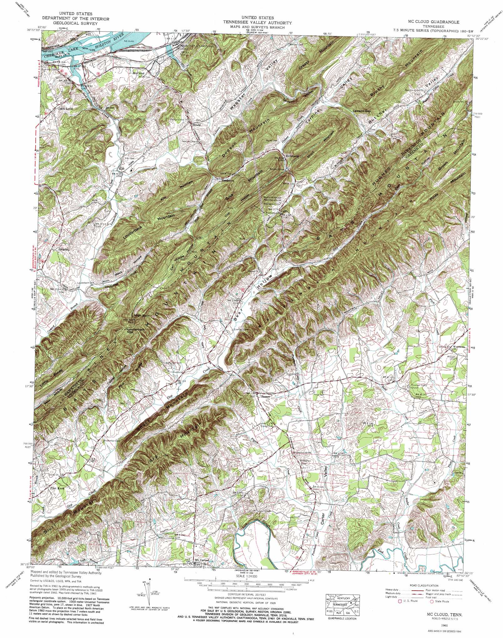
USGS Topo Quad 36082c8 - 1:24,000 scale
| Topo Map Name: | Mccloud |
| USGS Topo Quad ID: | 36082c8 |
| Print Size: | ca. 21 1/4" wide x 27" high |
| Southeast Coordinates: | 36.25° N latitude / 82.875° W longitude |
| Map Center Coordinates: | 36.3125° N latitude / 82.9375° W longitude |
| U.S. State: | TN |
| Filename: | o36082c8.jpg |
| Download Map JPG Image: | Mccloud topo map 1:24,000 scale |
| Map Type: | Topographic |
| Topo Series: | 7.5´ |
| Map Scale: | 1:24,000 |
| Source of Map Images: | United States Geological Survey (USGS) |
| Alternate Map Versions: |
McCloud TN 1935 Download PDF Buy paper map Mc Cloud TN 1939, updated 1960 Download PDF Buy paper map Mc Cloud TN 1940 Download PDF Buy paper map Mc Cloud TN 1961, updated 1965 Download PDF Buy paper map Mc Cloud TN 1961, updated 1981 Download PDF Buy paper map McCloud TN 2010 Download PDF Buy paper map McCloud TN 2013 Download PDF Buy paper map McCloud TN 2016 Download PDF Buy paper map |
1:24,000 Topo Quads surrounding Mccloud
Sneedville |
Kyles Ford |
Looneys Gap |
Plum Grove |
Church Hill |
Lee Valley |
Camelot |
Burem |
Stony Point |
Lovelace |
Russellville |
Bulls Gap |
Mccloud |
Baileyton |
Jearoldstown |
Springvale |
Mohawk |
Mosheim |
Greeneville |
Chuckey |
Rankin |
Parrotsville |
Cedar Creek |
Davy Crockett Lake |
Greystone |
> Back to 36082a1 at 1:100,000 scale
> Back to 36082a1 at 1:250,000 scale
> Back to U.S. Topo Maps home
Mccloud topo map: Gazetteer
Mccloud: Bars
McKinneys Shoals elevation 327m 1072′Mccloud: Dams
Malone Lake Dam elevation 340m 1115′Rolling G Dam elevation 360m 1181′
Mccloud: Gaps
Lawson Gap elevation 377m 1236′Louderback Gap elevation 483m 1584′
Mccloud: Islands
Arnotts Island elevation 328m 1076′McKinneys Islands elevation 327m 1072′
Mccloud: Populated Places
Brotherton elevation 359m 1177′Butcher (historical) elevation 389m 1276′
Chalk Level elevation 370m 1213′
Couch (historical) elevation 363m 1190′
Enterprise elevation 382m 1253′
Grigsby elevation 375m 1230′
McCloud elevation 348m 1141′
Morelock (historical) elevation 357m 1171′
Mount Carmel elevation 362m 1187′
Pilot Knob elevation 358m 1174′
Romeo elevation 376m 1233′
Spears (historical) elevation 330m 1082′
Strahl elevation 368m 1207′
Woodlawn elevation 363m 1190′
Mccloud: Reservoirs
Malone Lake elevation 340m 1115′Rolling G Lake elevation 360m 1181′
Mccloud: Ridges
Hughes Mountain elevation 592m 1942′Kite Mountain elevation 485m 1591′
Pilot Knobs elevation 447m 1466′
Piney Mountain elevation 588m 1929′
Mccloud: Streams
Babb Creek elevation 347m 1138′Coach Branch elevation 341m 1118′
Coward Branch elevation 342m 1122′
Dodson Creek elevation 327m 1072′
Heck Hollow Branch elevation 349m 1145′
Lick Slough elevation 335m 1099′
Little Gap Creek elevation 357m 1171′
Louderback Creek elevation 331m 1085′
Pigeon Creek elevation 338m 1108′
Plum Creek elevation 340m 1115′
Polly Branch elevation 338m 1108′
Roaring Fork elevation 338m 1108′
Saylor Creek elevation 337m 1105′
Mccloud: Summits
Big Mountain elevation 535m 1755′Bluff Mountain elevation 494m 1620′
Brokenback Mountain elevation 675m 2214′
Cove Mountain elevation 554m 1817′
Dodson Mountain elevation 531m 1742′
High Spur elevation 588m 1929′
Little Piney Mountain elevation 501m 1643′
Louderback Mountain elevation 532m 1745′
Short Mountain elevation 469m 1538′
Short Mountain elevation 580m 1902′
Mccloud: Valleys
Bear Hollow elevation 361m 1184′Butcher Valley elevation 392m 1286′
Carl Thorpe Hollow elevation 385m 1263′
Carter Valley elevation 337m 1105′
Cooter Hollow elevation 361m 1184′
Copp Hollow elevation 358m 1174′
Cup Hollow elevation 373m 1223′
Cup Hollow elevation 380m 1246′
Dodson Hollow elevation 341m 1118′
Heck Hollow elevation 341m 1118′
Tarpine Valley elevation 384m 1259′
Mccloud digital topo map on disk
Buy this Mccloud topo map showing relief, roads, GPS coordinates and other geographical features, as a high-resolution digital map file on DVD:
Western Virginia & Southern West Virginia
Buy digital topo maps: Western Virginia & Southern West Virginia