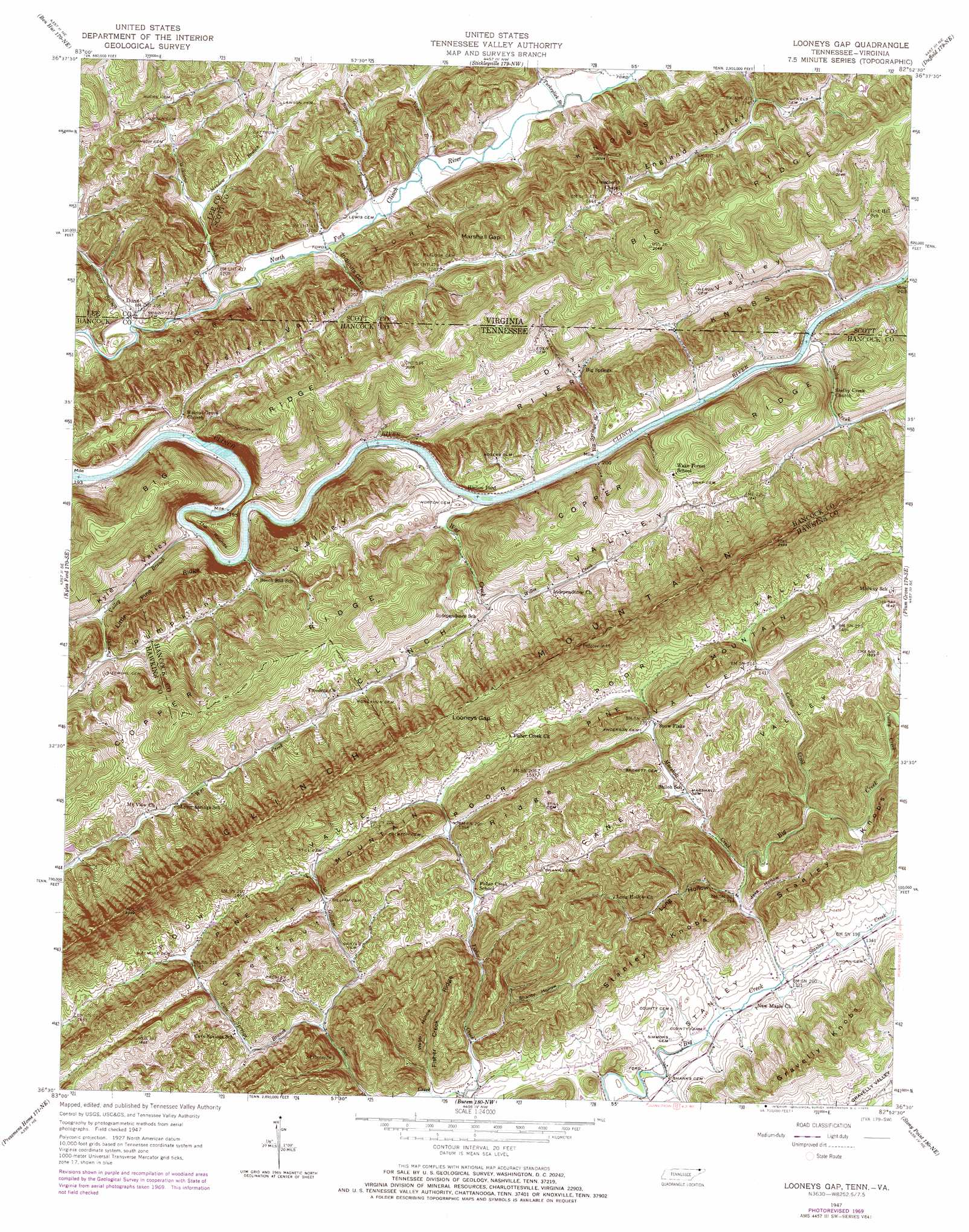
Looneys Gap Topo Map Tennessee
To zoom in, hover over the map of Looneys Gap
USGS Topo Quad 36082e8 - 1:24,000 scale
| Topo Map Name: | Looneys Gap |
| USGS Topo Quad ID: | 36082e8 |
| Print Size: | ca. 21 1/4" wide x 27" high |
| Southeast Coordinates: | 36.5° N latitude / 82.875° W longitude |
| Map Center Coordinates: | 36.5625° N latitude / 82.9375° W longitude |
| U.S. States: | TN, VA |
| Filename: | o36082e8.jpg |
| Download Map JPG Image: | Looneys Gap topo map 1:24,000 scale |
| Map Type: | Topographic |
| Topo Series: | 7.5´ |
| Map Scale: | 1:24,000 |
| Source of Map Images: | United States Geological Survey (USGS) |
| Alternate Map Versions: |
Looneys Gap TN 1935 Download PDF Buy paper map Looneys Gap TN 1947, updated 1970 Download PDF Buy paper map Looneys Gap TN 1950 Download PDF Buy paper map Looneys Gap TN 1976, updated 1981 Download PDF Buy paper map Looneys Gap TN 2010 Download PDF Buy paper map Looneys Gap TN 2013 Download PDF Buy paper map Looneys Gap TN 2016 Download PDF Buy paper map |
1:24,000 Topo Quads surrounding Looneys Gap
Evarts |
Pennington Gap |
Keokee |
Big Stone Gap |
East Stone Gap |
Hubbard Springs |
Ben Hur |
Stickleyville |
Duffield |
Clinchport |
Sneedville |
Kyles Ford |
Looneys Gap |
Plum Grove |
Church Hill |
Lee Valley |
Camelot |
Burem |
Stony Point |
Lovelace |
Russellville |
Bulls Gap |
Mccloud |
Baileyton |
Jearoldstown |
> Back to 36082e1 at 1:100,000 scale
> Back to 36082a1 at 1:250,000 scale
> Back to U.S. Topo Maps home
Looneys Gap topo map: Gazetteer
Looneys Gap: Bars
Rodgers Shoals elevation 350m 1148′Looneys Gap: Basins
Dry Valley elevation 427m 1400′Looneys Gap: Cliffs
The Rounds elevation 401m 1315′Looneys Gap: Crossings
Horton Ford elevation 357m 1171′Tigners Ford elevation 355m 1164′
Looneys Gap: Gaps
Dry Gap elevation 465m 1525′Indicuts Gap elevation 362m 1187′
Looneys Gap elevation 635m 2083′
Marshall Gap elevation 441m 1446′
Looneys Gap: Islands
Hortons Island elevation 358m 1174′Looneys Gap: Populated Places
Aunt (historical) elevation 402m 1318′Big Springs elevation 399m 1309′
Dona elevation 355m 1164′
Fisher Creek elevation 423m 1387′
Independence elevation 401m 1315′
Jennings Store elevation 364m 1194′
Looneys Gap: Ridges
Chestnut Ridge elevation 504m 1653′Fisher Creek Ridge elevation 526m 1725′
Little Pine Ridge elevation 533m 1748′
North Fork Knobs elevation 561m 1840′
Pine Mountain elevation 557m 1827′
Looneys Gap: Springs
Lynn Springs elevation 465m 1525′Looneys Gap: Streams
Beech Grove Branch elevation 354m 1161′Big Springs Branch elevation 360m 1181′
Big Springs Branch elevation 359m 1177′
Caney Creek elevation 449m 1473′
Cave Springs Branch elevation 406m 1332′
Clifton Creek elevation 413m 1354′
Cove Creek elevation 390m 1279′
Fisher Branch elevation 350m 1148′
Gilliam Creek elevation 406m 1332′
Marshall Creek elevation 408m 1338′
Meadow Branch elevation 375m 1230′
Nickels Branch elevation 356m 1167′
Robinette Branch elevation 351m 1151′
Shelby Creek elevation 364m 1194′
Stanley Creek elevation 401m 1315′
Turkeylick Branch elevation 359m 1177′
War Creek elevation 359m 1177′
Williams Branch elevation 351m 1151′
Willis Creek elevation 393m 1289′
Looneys Gap: Summits
Gravelly Knobs elevation 473m 1551′Stanley Knobs elevation 565m 1853′
Looneys Gap: Valleys
Dry Valley elevation 373m 1223′Fisher Valley elevation 357m 1171′
Fisher Valley elevation 363m 1190′
Housewright Hollow elevation 408m 1338′
Jake Hollow elevation 406m 1332′
Johnson Hollow elevation 357m 1171′
Kyle Valley elevation 357m 1171′
Long Hollow elevation 405m 1328′
Pumpkin Valley elevation 364m 1194′
Shanty Hollow elevation 430m 1410′
Webb Hollow elevation 403m 1322′
Looneys Gap digital topo map on disk
Buy this Looneys Gap topo map showing relief, roads, GPS coordinates and other geographical features, as a high-resolution digital map file on DVD:
Western Virginia & Southern West Virginia
Buy digital topo maps: Western Virginia & Southern West Virginia