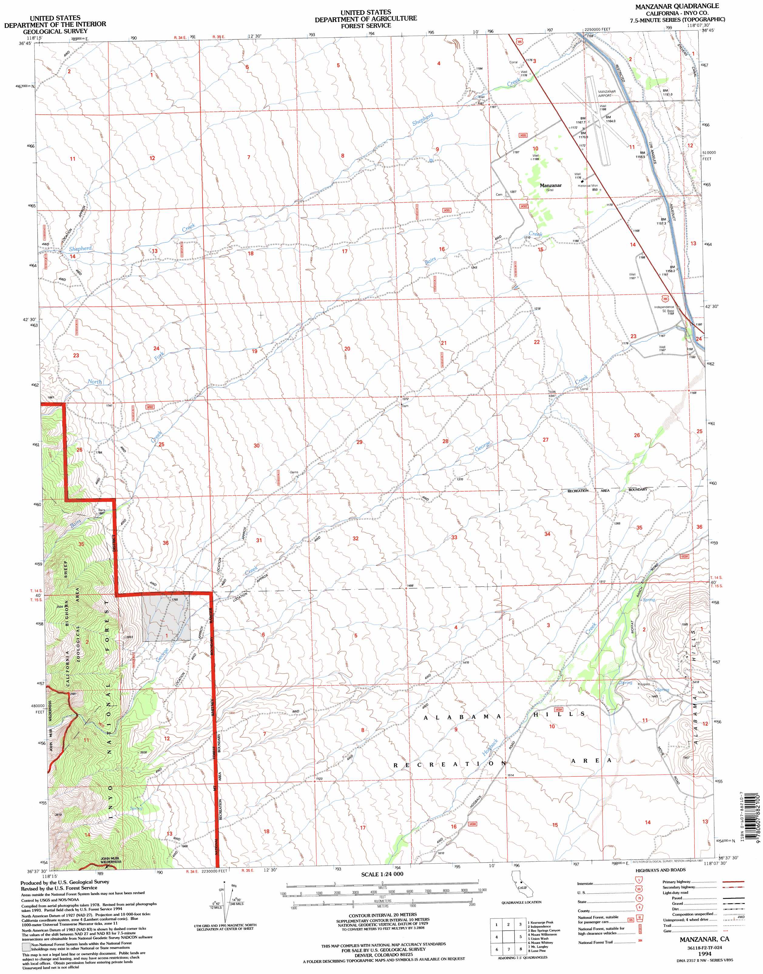
Manzanar Topo Map California
To zoom in, hover over the map of Manzanar
USGS Topo Quad 36118f2 - 1:24,000 scale
| Topo Map Name: | Manzanar |
| USGS Topo Quad ID: | 36118f2 |
| Print Size: | ca. 21 1/4" wide x 27" high |
| Southeast Coordinates: | 36.625° N latitude / 118.125° W longitude |
| Map Center Coordinates: | 36.6875° N latitude / 118.1875° W longitude |
| U.S. State: | CA |
| Filename: | o36118f2.jpg |
| Download Map JPG Image: | Manzanar topo map 1:24,000 scale |
| Map Type: | Topographic |
| Topo Series: | 7.5´ |
| Map Scale: | 1:24,000 |
| Source of Map Images: | United States Geological Survey (USGS) |
| Alternate Map Versions: |
Manzanar CA 1982, updated 1983 Download PDF Buy paper map Manzanar CA 1993, updated 1995 Download PDF Buy paper map Manzanar CA 1994, updated 1997 Download PDF Buy paper map Manzanar CA 2012 Download PDF Buy paper map Manzanar CA 2015 Download PDF Buy paper map |
| FStopo: | US Forest Service topo Manzanar is available: Download FStopo PDF Download FStopo TIF |
1:24,000 Topo Quads surrounding Manzanar
Mount Pinchot |
Aberdeen |
Blackrock |
Mazourka Peak |
Waucoba Canyon |
Mount Clarence King |
Kearsarge Peak |
Independence |
Bee Springs Canyon |
Pat Keyes Canyon |
Mount Brewer |
Mount Williamson |
Manzanar |
Union Wash |
New York Butte |
Mount Kaweah |
Mount Whitney |
Mount Langley |
Lone Pine |
Dolomite |
Chagoopa Falls |
Johnson Peak |
Cirque Peak |
Bartlett |
Owens Lake |
> Back to 36118e1 at 1:100,000 scale
> Back to 36118a1 at 1:250,000 scale
> Back to U.S. Topo Maps home
Manzanar topo map: Gazetteer
Manzanar: Parks
Manzanar National Historic Site elevation 1187m 3894′Manzanar War Relocation Center (historical) elevation 1187m 3894′
Merritt Park (historical) elevation 1198m 3930′
North Park (historical) elevation 1181m 3874′
Manzanar: Streams
Bairs Creek elevation 1161m 3809′George Creek elevation 1164m 3818′
North Fork Bairs Creek elevation 1438m 4717′
Manzanar digital topo map on disk
Buy this Manzanar topo map showing relief, roads, GPS coordinates and other geographical features, as a high-resolution digital map file on DVD:
Southern Sierra Nevada, California & Southern Nevada
Buy digital topo maps: Southern Sierra Nevada, California & Southern Nevada