Holiday Lake Topo Map Virginia
To zoom in, hover over the map of Holiday Lake
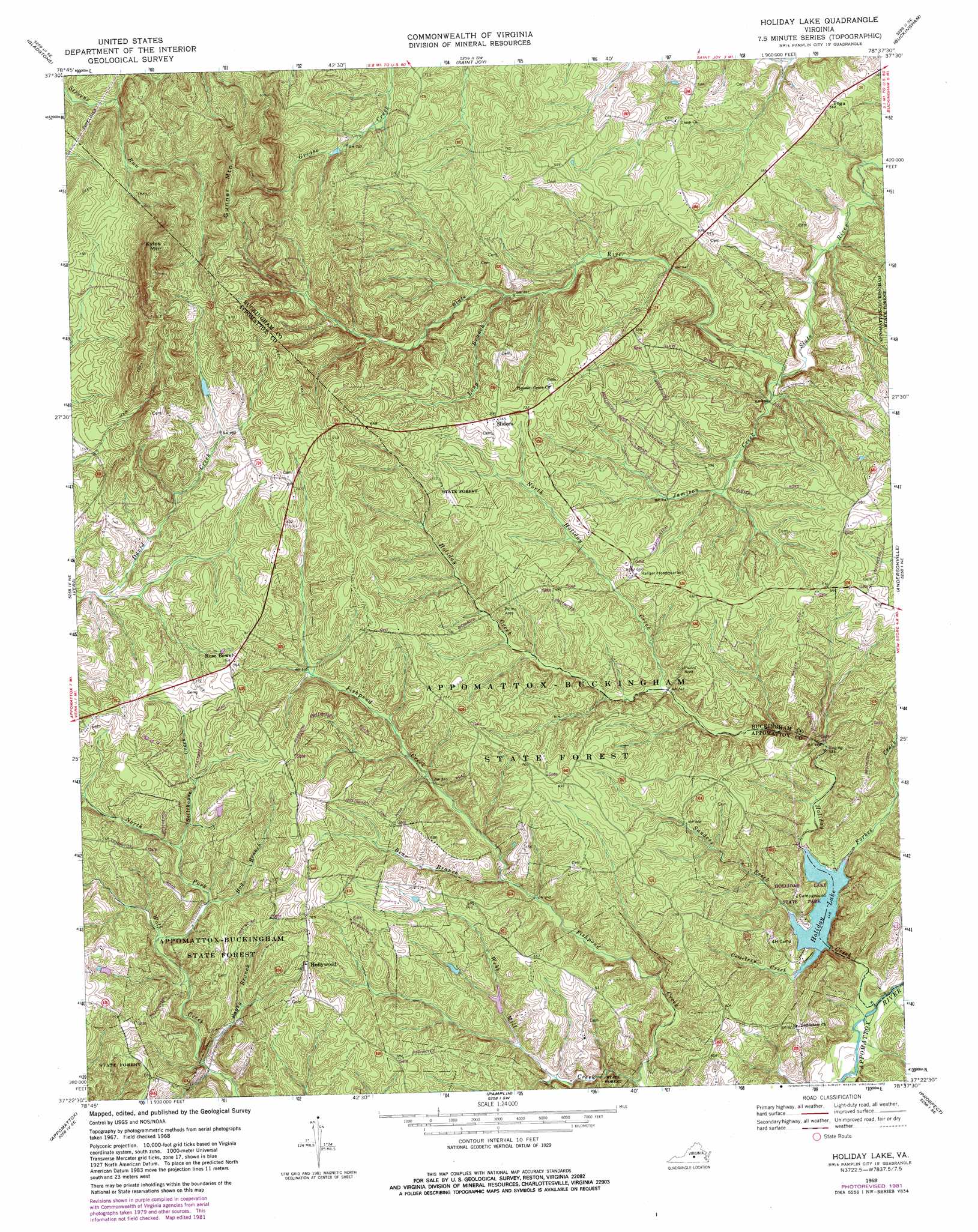
USGS Topo Quad 37078d6 - 1:24,000 scale
| Topo Map Name: | Holiday Lake |
| USGS Topo Quad ID: | 37078d6 |
| Print Size: | ca. 21 1/4" wide x 27" high |
| Southeast Coordinates: | 37.375° N latitude / 78.625° W longitude |
| Map Center Coordinates: | 37.4375° N latitude / 78.6875° W longitude |
| U.S. State: | VA |
| Filename: | o37078d6.jpg |
| Download Map JPG Image: | Holiday Lake topo map 1:24,000 scale |
| Map Type: | Topographic |
| Topo Series: | 7.5´ |
| Map Scale: | 1:24,000 |
| Source of Map Images: | United States Geological Survey (USGS) |
| Alternate Map Versions: |
Holiday Lake VA 1968, updated 1972 Download PDF Buy paper map Holiday Lake VA 1968, updated 1982 Download PDF Buy paper map Holiday Lake VA 1968, updated 1982 Download PDF Buy paper map Holiday Lake VA 2010 Download PDF Buy paper map Holiday Lake VA 2013 Download PDF Buy paper map Holiday Lake VA 2016 Download PDF Buy paper map |
1:24,000 Topo Quads surrounding Holiday Lake
Arrington |
Shipman |
Howardsville |
Glenmore |
Diana Mills |
Buffalo Ridge |
Gladstone |
Saint Joy |
Buckingham |
Dillwyn |
Stonewall |
Vera |
Holiday Lake |
Andersonville |
Willis Mountain |
Concord |
Appomattox |
Pamplin |
Prospect |
Farmville |
Mike |
Red House |
Madisonville |
Abilene |
Hampden Sydney |
> Back to 37078a1 at 1:100,000 scale
> Back to 37078a1 at 1:250,000 scale
> Back to U.S. Topo Maps home
Holiday Lake topo map: Gazetteer
Holiday Lake: Airports
Toga Airport elevation 217m 711′Holiday Lake: Dams
Holiday Dam elevation 132m 433′Holiday Lake: Parks
Appomattox Buckingham State Forest elevation 215m 705′Holiday Lake State Park elevation 169m 554′
Holiday Lake State Recreation Area elevation 158m 518′
Holiday Lake: Populated Places
Forbes (historical) elevation 210m 688′Fore Store elevation 201m 659′
Hollywood elevation 230m 754′
Sliders elevation 226m 741′
Toga elevation 173m 567′
Holiday Lake: Reservoirs
Holiday Lake elevation 135m 442′Holiday Lake elevation 132m 433′
Holiday Lake: Streams
Bear Branch elevation 167m 547′Cemetery Creek elevation 137m 449′
Forbes Creek elevation 135m 442′
Hog Branch elevation 188m 616′
Holiday Creek elevation 122m 400′
Jamison Creek elevation 149m 488′
Long Branch elevation 181m 593′
North Fork Wolf Creek elevation 180m 590′
North Holiday Creek elevation 165m 541′
Ragby Branch elevation 168m 551′
Sanders Creek elevation 136m 446′
Stillhouse Creek elevation 198m 649′
Webb Mill Creek elevation 141m 462′
Holiday Lake: Summits
Gunner Mountain elevation 344m 1128′Kyles Mountain elevation 354m 1161′
Holiday Lake digital topo map on disk
Buy this Holiday Lake topo map showing relief, roads, GPS coordinates and other geographical features, as a high-resolution digital map file on DVD:
Western Virginia & Southern West Virginia
Buy digital topo maps: Western Virginia & Southern West Virginia