Naugatuck Topo Map West Virginia
To zoom in, hover over the map of Naugatuck
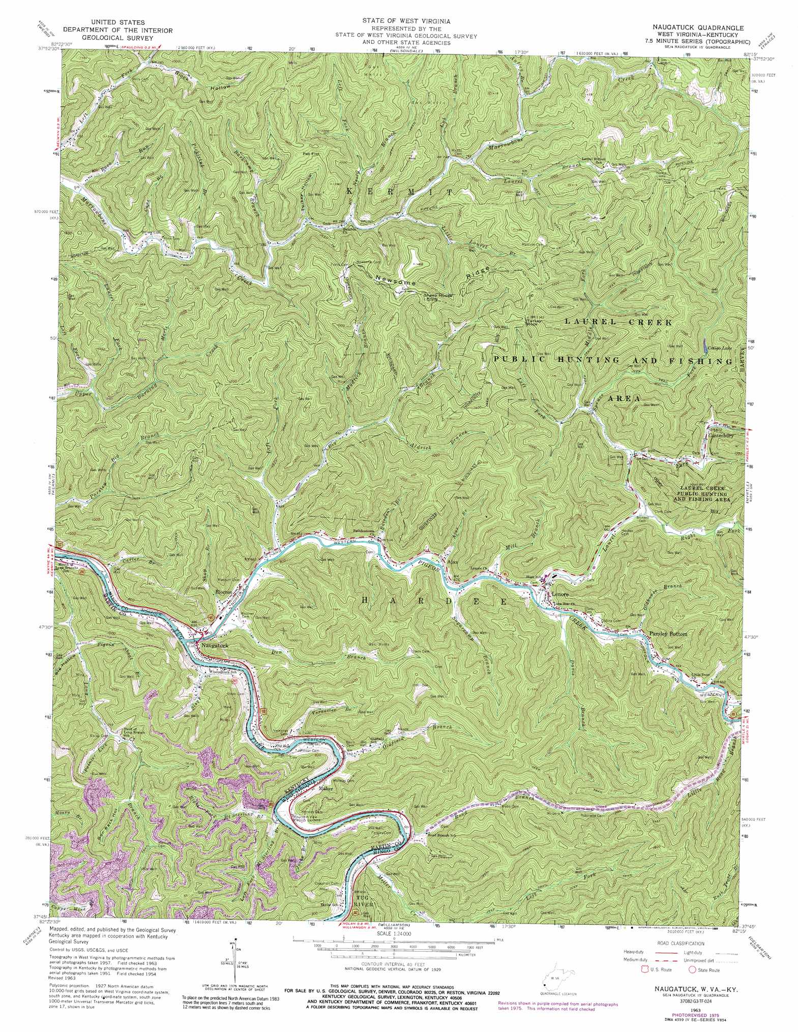
USGS Topo Quad 37082g3 - 1:24,000 scale
| Topo Map Name: | Naugatuck |
| USGS Topo Quad ID: | 37082g3 |
| Print Size: | ca. 21 1/4" wide x 27" high |
| Southeast Coordinates: | 37.75° N latitude / 82.25° W longitude |
| Map Center Coordinates: | 37.8125° N latitude / 82.3125° W longitude |
| U.S. States: | WV, KY |
| Filename: | o37082g3.jpg |
| Download Map JPG Image: | Naugatuck topo map 1:24,000 scale |
| Map Type: | Topographic |
| Topo Series: | 7.5´ |
| Map Scale: | 1:24,000 |
| Source of Map Images: | United States Geological Survey (USGS) |
| Alternate Map Versions: |
Naugatuck WV 1954, updated 1955 Download PDF Buy paper map Naugatuck WV 1963, updated 1965 Download PDF Buy paper map Naugatuck WV 1963, updated 1977 Download PDF Buy paper map Naugatuck WV 1963, updated 1989 Download PDF Buy paper map Naugatuck WV 1997, updated 2003 Download PDF Buy paper map Naugatuck WV 2010 Download PDF Buy paper map Naugatuck WV 2014 Download PDF Buy paper map Naugatuck WV 2016 Download PDF Buy paper map |
1:24,000 Topo Quads surrounding Naugatuck
Louisa |
Radnor |
Kiahsville |
Ranger |
Big Creek |
Milo |
Webb |
Wilsondale |
Trace |
Chapmanville |
Inez |
Kermit |
Naugatuck |
Myrtle |
Holden |
Thomas |
Varney |
Williamson |
Delbarton |
Barnabus |
Broad Bottom |
Meta |
Belfry |
Matewan |
Majestic |
> Back to 37082e1 at 1:100,000 scale
> Back to 37082a1 at 1:250,000 scale
> Back to U.S. Topo Maps home
Naugatuck topo map: Gazetteer
Naugatuck: Flats
Pat Flat elevation 385m 1263′Naugatuck: Pillars
Turkey Rock elevation 376m 1233′Naugatuck: Populated Places
Ajax elevation 197m 646′Blocton elevation 194m 636′
Canterbury elevation 206m 675′
Lenore elevation 203m 666′
Maher elevation 196m 643′
Naugatuck elevation 191m 626′
Parsley Bottom elevation 199m 652′
Rapp elevation 197m 646′
Naugatuck: Post Offices
Lenore Post Office elevation 197m 646′Naugatuck Post Office elevation 194m 636′
Naugatuck: Reservoirs
Cotigo Lake elevation 247m 810′Naugatuck: Ridges
Newsome Ridge elevation 448m 1469′Naugatuck: Streams
Ajax Branch elevation 188m 616′Aldrich Branch elevation 225m 738′
Antley Branch elevation 241m 790′
Baisden Branch elevation 186m 610′
Barkcamp Branch elevation 204m 669′
Big Branch elevation 184m 603′
Buck Run elevation 188m 616′
Cane Branch elevation 193m 633′
Carter Branch elevation 185m 606′
Cub Branch elevation 228m 748′
Dan Branch elevation 249m 816′
Davis Branch elevation 192m 629′
Den Branch elevation 186m 610′
Hensley Big Branch elevation 194m 636′
Jacks Branch elevation 185m 606′
Laurel Branch elevation 232m 761′
Laurel Fork elevation 212m 695′
Laurel Fork elevation 189m 620′
Left Fork Big Branch elevation 199m 652′
Left Fork Mount Sterling Branch elevation 190m 623′
Left Fork Neely Branch elevation 232m 761′
Left Fork Spruce Fork elevation 208m 682′
Left Fork Upper Burning Creek elevation 220m 721′
Little Laurel Branch elevation 220m 721′
Little Road Branch elevation 198m 649′
Marie Branch elevation 245m 803′
Middle Fork Spruce Fork elevation 210m 688′
Mill Branch elevation 188m 616′
Miller Creek elevation 188m 616′
Mudlick Branch elevation 217m 711′
Neely Branch elevation 215m 705′
Oldfield Branch elevation 184m 603′
Oldhouse Branch elevation 194m 636′
Painter Lick elevation 236m 774′
Pickletub Branch elevation 197m 646′
Pigeon Branch elevation 202m 662′
Pigeon Creek elevation 183m 600′
Right Fork Laurel Fork elevation 194m 636′
Right Fork Mount Sterling Branch elevation 191m 626′
Road Branch elevation 186m 610′
Shop Branch elevation 190m 623′
Spruce Fork elevation 198m 649′
Stepp Branch elevation 182m 597′
Sugarcamp Branch elevation 190m 623′
Sweetwater Branch elevation 200m 656′
Trace Fork elevation 261m 856′
Vernatter Branch elevation 193m 633′
White Branch elevation 194m 636′
Naugatuck: Summits
Sheep House Knob elevation 449m 1473′Naugatuck: Valleys
Big Hollow elevation 203m 666′Block Hollow elevation 224m 734′
Gun Rack Hollow elevation 256m 839′
Turkey Hollow elevation 211m 692′
Naugatuck digital topo map on disk
Buy this Naugatuck topo map showing relief, roads, GPS coordinates and other geographical features, as a high-resolution digital map file on DVD:
Western Virginia & Southern West Virginia
Buy digital topo maps: Western Virginia & Southern West Virginia