Pagosa Springs Topo Map Colorado
To zoom in, hover over the map of Pagosa Springs
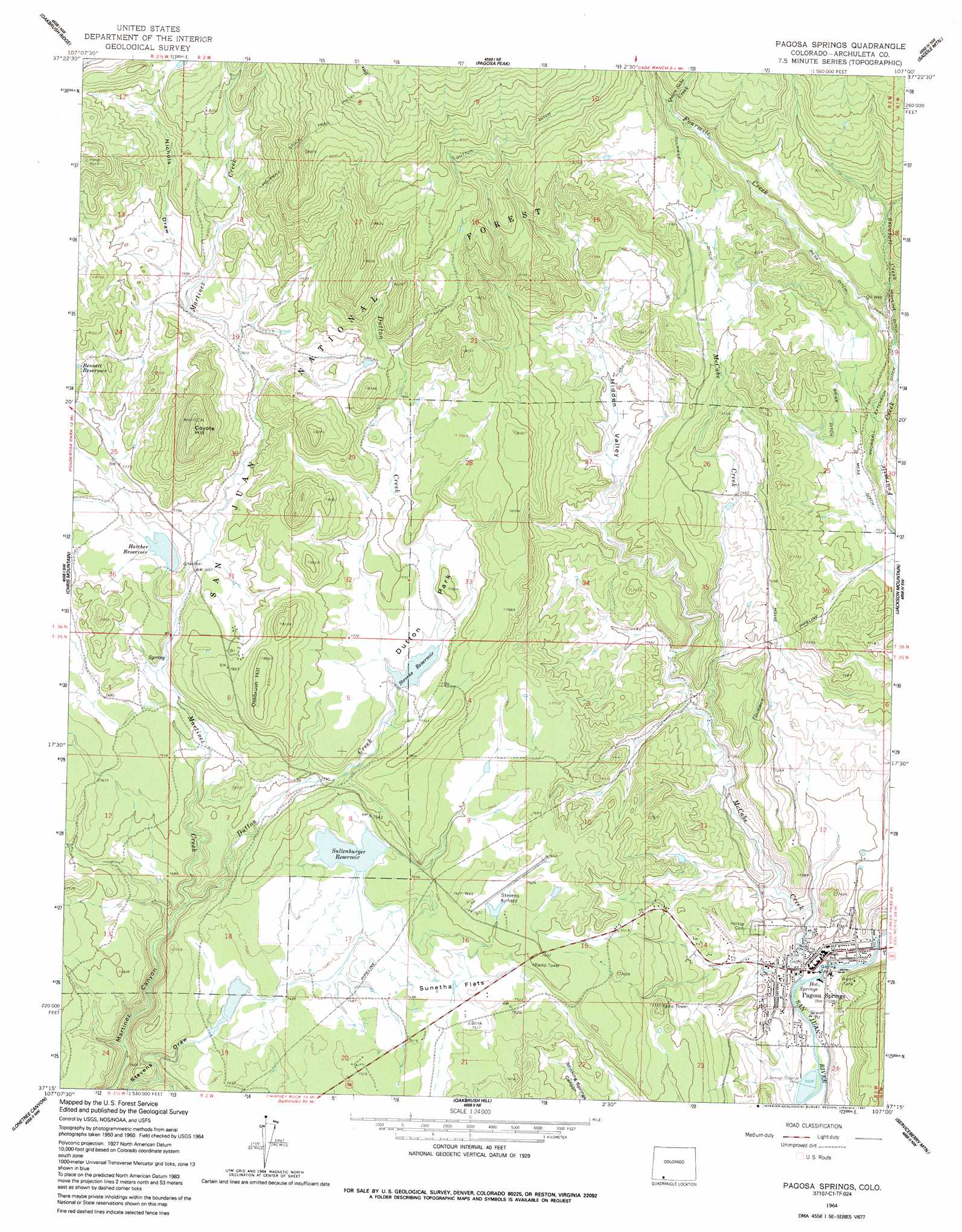
USGS Topo Quad 37107c1 - 1:24,000 scale
| Topo Map Name: | Pagosa Springs |
| USGS Topo Quad ID: | 37107c1 |
| Print Size: | ca. 21 1/4" wide x 27" high |
| Southeast Coordinates: | 37.25° N latitude / 107° W longitude |
| Map Center Coordinates: | 37.3125° N latitude / 107.0625° W longitude |
| U.S. State: | CO |
| Filename: | o37107c1.jpg |
| Download Map JPG Image: | Pagosa Springs topo map 1:24,000 scale |
| Map Type: | Topographic |
| Topo Series: | 7.5´ |
| Map Scale: | 1:24,000 |
| Source of Map Images: | United States Geological Survey (USGS) |
| Alternate Map Versions: |
Pagosa Springs CO 1964, updated 1967 Download PDF Buy paper map Pagosa Springs CO 1964, updated 1967 Download PDF Buy paper map Pagosa Springs CO 1964, updated 1991 Download PDF Buy paper map Pagosa Springs CO 2011 Download PDF Buy paper map Pagosa Springs CO 2013 Download PDF Buy paper map Pagosa Springs CO 2016 Download PDF Buy paper map |
| FStopo: | US Forest Service topo Pagosa Springs is available: Download FStopo PDF Download FStopo TIF |
1:24,000 Topo Quads surrounding Pagosa Springs
Granite Lake |
Cimarrona Peak |
Palomino Mountain |
South River Creek |
Mount Hope |
Bear Mountain |
Oakbrush Ridge |
Pagosa Peak |
Saddle Mountain |
Wolf Creek Pass |
Devil Mountain |
Chris Mountain |
Pagosa Springs |
Jackson Mountain |
Blackhead Peak |
Chimney Rock |
Lonetree Canyon |
Oakbrush Hill |
Serviceberry Mountain |
Harris Lake |
Carracas |
Pagosa Junction |
Trujillo |
Edith |
Chromo |
> Back to 37107a1 at 1:100,000 scale
> Back to 37106a1 at 1:250,000 scale
> Back to U.S. Topo Maps home
Pagosa Springs topo map: Gazetteer
Pagosa Springs: Airports
Stevens Field elevation 2330m 7644′Pagosa Springs: Canals
Briar Ditch elevation 2336m 7664′Dutton Ditch elevation 2538m 8326′
Fourmile Ditch elevation 2307m 7568′
Highline Ditch elevation 2333m 7654′
Mesa Ditch elevation 2326m 7631′
Snowball Extension Ditch elevation 2295m 7529′
Snowball Extention Ditch elevation 2160m 7086′
Pagosa Springs: Dams
Hatcher Dam elevation 2348m 7703′Lake Forest Dam elevation 2263m 7424′
Linn and Clark Dam elevation 2287m 7503′
Pinon Lake Dam elevation 2289m 7509′
Stevens Dam elevation 2361m 7746′
Town Center Dam elevation 2282m 7486′
Pagosa Springs: Flats
Dutton Park elevation 2367m 7765′Sunetha Flats elevation 2292m 7519′
Pagosa Springs: Mines
Copper Queen Mine elevation 2152m 7060′Iceland Spar Mine elevation 2511m 8238′
Meadows Property Mine elevation 2502m 8208′
Treasure-Comstock Mine elevation 2152m 7060′
Pagosa Springs: Populated Places
Pagosa Springs elevation 2172m 7125′Pagosa Springs: Reservoirs
Borns Lake Reservoir elevation 2278m 7473′Bramwell Reservoir Number 2 elevation 2282m 7486′
Lake Forest elevation 2263m 7424′
Lake Hatcher elevation 2348m 7703′
Lake Pagosa elevation 2288m 7506′
Pinon Lake Reservoir elevation 2289m 7509′
Stevens Reservoir elevation 2361m 7746′
Village Lake elevation 2281m 7483′
Pagosa Springs: Springs
Hot Springs elevation 2153m 7063′Pagosa Springs elevation 2152m 7060′
Pagosa Springs: Streams
Dutton Creek elevation 2242m 7355′McCabe Creek elevation 2152m 7060′
Quien Sabe Creek elevation 2424m 7952′
Snowball Creek elevation 2310m 7578′
Pagosa Springs: Summits
Coyote Hill elevation 2575m 8448′Oakbrush Hill elevation 2455m 8054′
Pagosa Springs: Valleys
Hidden Valley elevation 2291m 7516′Horse Gulch elevation 2161m 7089′
Nichols Draw elevation 2401m 7877′
Pagosa Springs digital topo map on disk
Buy this Pagosa Springs topo map showing relief, roads, GPS coordinates and other geographical features, as a high-resolution digital map file on DVD: