Santa Clara Topo Map Utah
To zoom in, hover over the map of Santa Clara
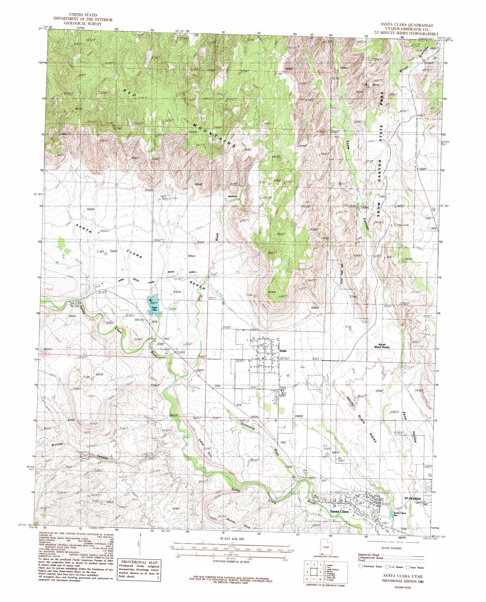
USGS Topo Quad 37113b6 - 1:24,000 scale
| Topo Map Name: | Santa Clara |
| USGS Topo Quad ID: | 37113b6 |
| Print Size: | ca. 21 1/4" wide x 27" high |
| Southeast Coordinates: | 37.125° N latitude / 113.625° W longitude |
| Map Center Coordinates: | 37.1875° N latitude / 113.6875° W longitude |
| U.S. State: | UT |
| Filename: | o37113b6.jpg |
| Download Map JPG Image: | Santa Clara topo map 1:24,000 scale |
| Map Type: | Topographic |
| Topo Series: | 7.5´ |
| Map Scale: | 1:24,000 |
| Source of Map Images: | United States Geological Survey (USGS) |
| Alternate Map Versions: |
St. George NW UT 1956, updated 1956 Download PDF Buy paper map Santa Clara UT 1986, updated 1987 Download PDF Buy paper map Santa Clara UT 2011 Download PDF Buy paper map Santa Clara UT 2014 Download PDF Buy paper map |
1:24,000 Topo Quads surrounding Santa Clara
Goldstrike |
Maple Ridge |
Central West |
Central East |
Grass Valley |
Motoqua |
Gunlock |
Veyo |
Saddle Mountain |
Signal Peak |
West Mountain Peak |
Shivwits |
Santa Clara |
Washington |
Harrisburg Junction |
Castle Cliff |
Jarvis Peak |
White Hills |
Saint George |
Washington Dome |
Littlefield |
Mountain Sheep Spring |
Purgatory Canyon |
Lizard Point |
Yellowhorse Flat |
> Back to 37113a1 at 1:100,000 scale
> Back to 37112a1 at 1:250,000 scale
> Back to U.S. Topo Maps home
Santa Clara topo map: Gazetteer
Santa Clara: Basins
Hellhole elevation 1033m 3389′Santa Clara: Benches
Santa Clara Bench elevation 997m 3270′Santa Clara: Canals
Lower Santa Clara Bench Canal elevation 925m 3034′Upper Santa Clara Bench Canal elevation 980m 3215′
Santa Clara: Dams
Ivins Bench Dam elevation 939m 3080′Santa Clara: Parks
Jacob Hamblin Home Historical Site elevation 850m 2788′Santa Clara: Populated Places
Ivins elevation 939m 3080′Santa Clara elevation 842m 2762′
Santa Clara: Ranges
Red Mountains elevation 1498m 4914′Santa Clara: Reservoirs
Ivins Bench Reservoir elevation 939m 3080′Ivins Reservoir elevation 947m 3106′
Santa Clara Reservoir elevation 843m 2765′
Santa Clara: Springs
Snow Spring elevation 950m 3116′Santa Clara: Summits
Land Hill elevation 1002m 3287′North Black Rocks elevation 937m 3074′
South Black Rocks elevation 891m 2923′
Santa Clara: Valleys
Dry Wash elevation 909m 2982′Graveyard Wash elevation 849m 2785′
Snow Canyon elevation 1015m 3330′
Winter Quarters elevation 1290m 4232′
Wittwer Canyon elevation 889m 2916′
Santa Clara digital topo map on disk
Buy this Santa Clara topo map showing relief, roads, GPS coordinates and other geographical features, as a high-resolution digital map file on DVD: