Louisa Topo Map Kentucky
To zoom in, hover over the map of Louisa
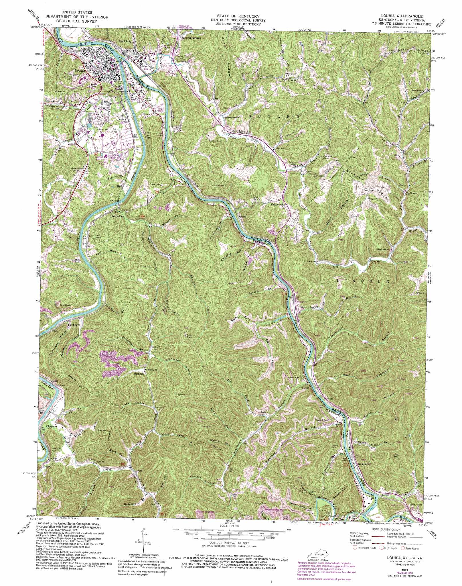
USGS Topo Quad 38082a5 - 1:24,000 scale
| Topo Map Name: | Louisa |
| USGS Topo Quad ID: | 38082a5 |
| Print Size: | ca. 21 1/4" wide x 27" high |
| Southeast Coordinates: | 38° N latitude / 82.5° W longitude |
| Map Center Coordinates: | 38.0625° N latitude / 82.5625° W longitude |
| U.S. States: | KY, WV |
| Filename: | o38082a5.jpg |
| Download Map JPG Image: | Louisa topo map 1:24,000 scale |
| Map Type: | Topographic |
| Topo Series: | 7.5´ |
| Map Scale: | 1:24,000 |
| Source of Map Images: | United States Geological Survey (USGS) |
| Alternate Map Versions: |
Louisa KY 1953, updated 1955 Download PDF Buy paper map Louisa KY 1962, updated 1963 Download PDF Buy paper map Louisa KY 1971, updated 1973 Download PDF Buy paper map Louisa KY 1971, updated 1977 Download PDF Buy paper map Louisa KY 1971, updated 1989 Download PDF Buy paper map Louisa KY 1971, updated 1993 Download PDF Buy paper map Louisa KY 2011 Download PDF Buy paper map Louisa KY 2013 Download PDF Buy paper map Louisa KY 2016 Download PDF Buy paper map |
1:24,000 Topo Quads surrounding Louisa
Rush |
Boltsfork |
Burnaugh |
Lavalette |
Winslow |
Webbville |
Fallsburg |
Prichard |
Wayne |
Nestlow |
Blaine |
Adams |
Louisa |
Radnor |
Kiahsville |
Sitka |
Richardson |
Milo |
Webb |
Wilsondale |
Paintsville |
Offutt |
Inez |
Kermit |
Naugatuck |
> Back to 38082a1 at 1:100,000 scale
> Back to 38082a1 at 1:250,000 scale
> Back to U.S. Topo Maps home
Louisa topo map: Gazetteer
Louisa: Bridges
Louisa and Fort Gay Bridge elevation 167m 547′Louisa: Capes
The Point elevation 180m 590′Louisa: Dams
Lock and Dam 3 elevation 165m 541′US Lock Number 1 on the Levisa Fork elevation 165m 541′
US Lock Number 1 Tug River elevation 168m 551′
Louisa: Populated Places
Chapman elevation 179m 587′Clifford elevation 188m 616′
Donathon elevation 194m 636′
Effie elevation 211m 692′
Fort Gay elevation 176m 577′
Gallup elevation 177m 580′
Glenhayes elevation 184m 603′
Holt elevation 180m 590′
Louisa elevation 178m 583′
Mineral Springs elevation 172m 564′
Saltpetre elevation 206m 675′
Smoky Valley elevation 225m 738′
Summit elevation 224m 734′
Torchlight elevation 194m 636′
Walbridge elevation 205m 672′
Louisa: Post Offices
Clifford Post Office (historical) elevation 187m 613′Gallop Post Office (historical) elevation 178m 583′
Maynard Post Office (historical) elevation 192m 629′
Vinson Post Office (historical) elevation 170m 557′
Walbridge Post Office (historical) elevation 183m 600′
Louisa: Ridges
Bromley Ridge elevation 321m 1053′Pine Ridge elevation 297m 974′
Louisa: Streams
Bull Branch elevation 169m 554′Burgess Branch elevation 174m 570′
Burgess Fork elevation 176m 577′
Campbell Run elevation 169m 554′
Clayton Branch elevation 170m 557′
Contrary Branch elevation 163m 534′
Donithan Branch elevation 168m 551′
Drinking Branch elevation 161m 528′
Fall Rock Branch elevation 175m 574′
Fall Rock Branch elevation 165m 541′
Field Branch elevation 163m 534′
Fulkerson Branch elevation 165m 541′
Gavitts Branch elevation 162m 531′
Gobber Creek elevation 175m 574′
Griffin Creek elevation 170m 557′
Honest Fork elevation 175m 574′
Joe Fork elevation 172m 564′
Laurel Fork elevation 187m 613′
Left Fork Griffin Creek elevation 176m 577′
Left Fork Mill Creek elevation 193m 633′
Left Fork Vinson Branch elevation 173m 567′
Levisa Fork elevation 166m 544′
Lick Branch elevation 169m 554′
Lick Creek elevation 166m 544′
Long Branch elevation 203m 666′
Long Branch elevation 198m 649′
Long Fork elevation 177m 580′
Lost Creek elevation 170m 557′
Lower Right Fork elevation 169m 554′
Maynard Branch elevation 168m 551′
Mill Branch elevation 185m 606′
Mill Creek elevation 167m 547′
Millseat Branch elevation 167m 547′
Muddy Run elevation 195m 639′
Owen Peck Branch elevation 188m 616′
Paddle Creek elevation 174m 570′
Patrick Branch elevation 168m 551′
Powdermill Branch elevation 168m 551′
Pratt Branch elevation 196m 643′
Rice Branch elevation 163m 534′
Right Fork Mill Creek elevation 195m 639′
Right Fork Vinson Branch elevation 175m 574′
Rockcastle Creek elevation 170m 557′
Rush Branch elevation 210m 688′
Savage Branch elevation 168m 551′
See Branch elevation 170m 557′
Selbee Branch elevation 208m 682′
Slatelick Branch elevation 179m 587′
Spring Branch elevation 169m 554′
Sprucey Branch elevation 193m 633′
Stone Branch elevation 171m 561′
Storehouse Branch elevation 210m 688′
Straight Fork elevation 197m 646′
Sulphur Spring Branch elevation 163m 534′
Threemile Creek elevation 173m 567′
Town Branch elevation 246m 807′
Trace Branch elevation 180m 590′
Tug Fork elevation 166m 544′
Upper Stone Branch elevation 168m 551′
Vinson Branch elevation 168m 551′
Vinson Branch elevation 168m 551′
Ward Branch elevation 176m 577′
Wilson Branch elevation 210m 688′
Wolfpen Branch elevation 173m 567′
Zock Branch elevation 163m 534′
Louisa: Valleys
Bates Cabin Hollow elevation 181m 593′Castle Hollow elevation 208m 682′
Frazier Hollow elevation 179m 587′
Oil Well Hollow elevation 183m 600′
Ratcliffe Hollow elevation 171m 561′
Stonecoal Hollow elevation 212m 695′
Torchlight Hollow elevation 176m 577′
Williamson Hollow elevation 169m 554′
Workman Hollow elevation 182m 597′
Louisa digital topo map on disk
Buy this Louisa topo map showing relief, roads, GPS coordinates and other geographical features, as a high-resolution digital map file on DVD:
Western Virginia & Southern West Virginia
Buy digital topo maps: Western Virginia & Southern West Virginia