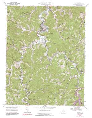
Wayne Topo Map West Virginia
To zoom in, hover over the map of Wayne
USGS Topo Quad 38082b4 - 1:24,000 scale
| Topo Map Name: | Wayne |
| USGS Topo Quad ID: | 38082b4 |
| Print Size: | ca. 21 1/4" wide x 27" high |
| Southeast Coordinates: | 38.125° N latitude / 82.375° W longitude |
| Map Center Coordinates: | 38.1875° N latitude / 82.4375° W longitude |
| U.S. State: | WV |
| Filename: | o38082b4.jpg |
| Download Map JPG Image: | Wayne topo map 1:24,000 scale |
| Map Type: | Topographic |
| Topo Series: | 7.5´ |
| Map Scale: | 1:24,000 |
| Source of Map Images: | United States Geological Survey (USGS) |
| Alternate Map Versions: |
Wayne WV 1962, updated 1963 Download PDF Buy paper map Wayne WV 1962, updated 1977 Download PDF Buy paper map Wayne WV 1962, updated 1991 Download PDF Buy paper map Wayne WV 2011 Download PDF Buy paper map Wayne WV 2014 Download PDF Buy paper map Wayne WV 2016 Download PDF Buy paper map |
1:24,000 Topo Quads surrounding Wayne
> Back to 38082a1 at 1:100,000 scale
> Back to 38082a1 at 1:250,000 scale
> Back to U.S. Topo Maps home
Wayne topo map: Gazetteer
Wayne: Dams
East Lynn Dam elevation 205m 672′Wayne: Gaps
Sand Gap elevation 300m 984′Wayne: Lakes
Mam-Maw Lake elevation 193m 633′Wayne: Populated Places
Armilda elevation 191m 626′Bethesda elevation 193m 633′
Coleman elevation 191m 626′
Crockett elevation 198m 649′
East Lynn elevation 193m 633′
Echo elevation 190m 623′
Elmwood elevation 190m 623′
Sidney elevation 193m 633′
Stiltner elevation 231m 757′
Wayne elevation 212m 695′
Wayne: Post Offices
East Lynn Post Office elevation 191m 626′Wayne: Reservoirs
East Lynn Lake elevation 204m 669′Wayne: Streams
Bartram Branch elevation 200m 656′Battern Fork elevation 188m 616′
Big Branch elevation 179m 587′
Booth Branch elevation 192m 629′
Booth Branch elevation 184m 603′
Brush Creek elevation 200m 656′
Camp Creek elevation 187m 613′
Deephole Branch elevation 189m 620′
East Fork Twelvepole Creek elevation 181m 593′
Edds Branch elevation 181m 593′
Flat Branch elevation 190m 623′
Fraley Fork elevation 197m 646′
Greenbrier Creek elevation 188m 616′
Joels Branch elevation 187m 613′
Johnnys Branch elevation 179m 587′
Kilpeck Branch elevation 185m 606′
Lambert Branch elevation 188m 616′
Laurel Creek elevation 192m 629′
Left Fork Lynn Creek elevation 200m 656′
Left Fork Wilson Creek elevation 177m 580′
Lick Branch elevation 204m 669′
Little Lynn Creek elevation 190m 623′
Luster Fork elevation 197m 646′
Lynn Creek elevation 186m 610′
Meeks Branch elevation 225m 738′
Middle Fork Wilson Creek elevation 181m 593′
Newcomb Creek elevation 185m 606′
Onemile Creek elevation 182m 597′
Patrick Creek elevation 180m 590′
Petercave Branch elevation 186m 610′
Right Fork Lynn Creek elevation 200m 656′
Rockhouse Branch elevation 215m 705′
Sycamore Branch elevation 190m 623′
Toms Creek elevation 183m 600′
Trace Fork elevation 185m 606′
Twomile Creek elevation 180m 590′
West Fork Twelvepole Creek elevation 181m 593′
White Oak Fork elevation 199m 652′
Wilson Creek elevation 173m 567′
Wolf Creek elevation 188m 616′
Wayne: Summits
Wheeler Knob elevation 344m 1128′Wayne: Valleys
Deadwood Hollow elevation 185m 606′Lynn Hollow elevation 200m 656′
Rocky Hollow elevation 187m 613′
Wayne digital topo map on disk
Buy this Wayne topo map showing relief, roads, GPS coordinates and other geographical features, as a high-resolution digital map file on DVD:
Western Virginia & Southern West Virginia
Buy digital topo maps: Western Virginia & Southern West Virginia


