New Boston Topo Map Ohio
To zoom in, hover over the map of New Boston
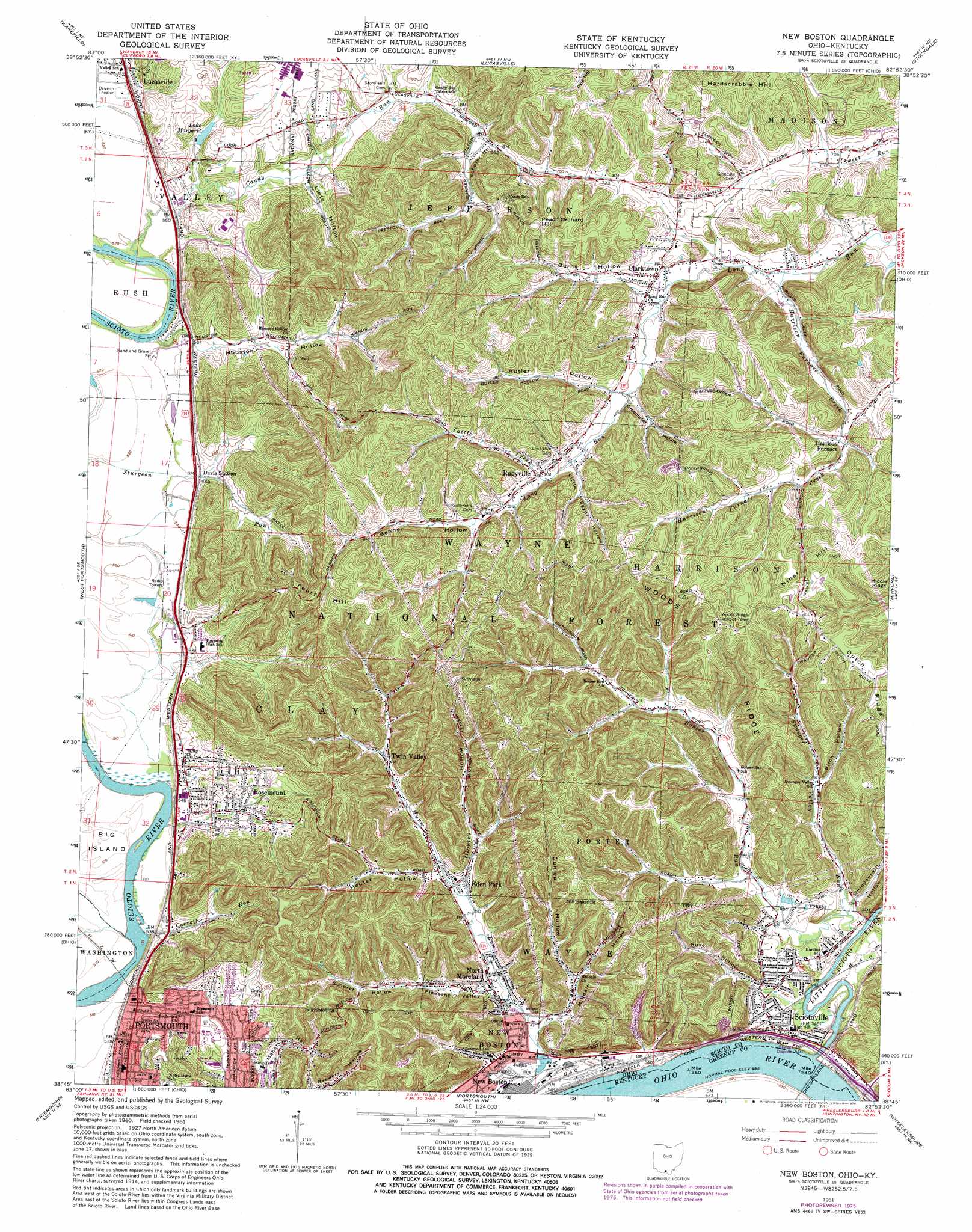
USGS Topo Quad 38082g8 - 1:24,000 scale
| Topo Map Name: | New Boston |
| USGS Topo Quad ID: | 38082g8 |
| Print Size: | ca. 21 1/4" wide x 27" high |
| Southeast Coordinates: | 38.75° N latitude / 82.875° W longitude |
| Map Center Coordinates: | 38.8125° N latitude / 82.9375° W longitude |
| U.S. States: | OH, KY |
| Filename: | o38082g8.jpg |
| Download Map JPG Image: | New Boston topo map 1:24,000 scale |
| Map Type: | Topographic |
| Topo Series: | 7.5´ |
| Map Scale: | 1:24,000 |
| Source of Map Images: | United States Geological Survey (USGS) |
| Alternate Map Versions: |
New Boston OH 1961, updated 1962 Download PDF Buy paper map New Boston OH 1961, updated 1973 Download PDF Buy paper map New Boston OH 1961, updated 1976 Download PDF Buy paper map New Boston OH 2010 Download PDF Buy paper map New Boston OH 2013 Download PDF Buy paper map New Boston OH 2016 Download PDF Buy paper map |
1:24,000 Topo Quads surrounding New Boston
Latham |
Piketon |
Waverly South |
Beaver |
Jackson |
Rarden |
Wakefield |
Lucasville |
Stockdale |
Petersburg |
Otway |
West Portsmouth |
New Boston |
Minford |
South Webster |
Pond Run |
Friendship |
Portsmouth |
Wheelersburg |
Pedro |
Garrison |
Brushart |
Load |
Greenup |
Ironton |
> Back to 38082e1 at 1:100,000 scale
> Back to 38082a1 at 1:250,000 scale
> Back to U.S. Topo Maps home
New Boston topo map: Gazetteer
New Boston: Bars
Little Scioto Bar elevation 148m 485′New Boston: Dams
Lake Margaret Dam elevation 175m 574′New Boston: Parks
New Boston Stadium elevation 160m 524′New Boston: Populated Places
Clarktown elevation 207m 679′Colony Mobile Home Park elevation 162m 531′
East Portsmouth (historical) elevation 167m 547′
Eden Park elevation 178m 583′
Harrison Furnace elevation 215m 705′
Modern Mobile Home Park elevation 174m 570′
New Boston elevation 156m 511′
North Moreland elevation 168m 551′
Portsmouth Mobile Home Park elevation 166m 544′
Rosemount elevation 185m 606′
Rubyville elevation 209m 685′
Sciotoville elevation 164m 538′
Twin Valley elevation 199m 652′
Vera Junction elevation 170m 557′
New Boston: Post Offices
New Boston Post Office (historical) elevation 181m 593′Sciotoville Post Office (historical) elevation 189m 620′
New Boston: Reservoirs
Lake Margaret elevation 175m 574′New Boston: Ridges
Middle Ridge elevation 283m 928′Woods Ridge elevation 309m 1013′
New Boston: Streams
Bonser Run elevation 152m 498′Candy Run elevation 155m 508′
Carroll Run elevation 153m 501′
Harrison Furnace Creek elevation 198m 649′
Little Scioto River elevation 154m 505′
Munn Run elevation 160m 524′
Pond Creek elevation 153m 501′
Swauger Valley Run elevation 159m 521′
Tattle Creek elevation 211m 692′
New Boston: Summits
Feurt Hill elevation 304m 997′Hardscrabble Hill elevation 293m 961′
Middle Ridge elevation 280m 918′
Niner Hill elevation 307m 1007′
New Boston: Valleys
Benner Hollow elevation 233m 764′Birch Hollow elevation 180m 590′
Burns Hollow elevation 219m 718′
Butler Hollow elevation 220m 721′
Coon Hollow elevation 166m 544′
Dunlop Hollow elevation 174m 570′
Fort Hollow elevation 177m 580′
Greenbrier Hollow elevation 214m 702′
Heuter Hollow elevation 176m 577′
Hinkley Hollow elevation 177m 580′
Horner Hollow elevation 171m 561′
Houston Hollow elevation 169m 554′
Johnson Hollow elevation 173m 567′
Lintz Hollow elevation 171m 561′
Milldale Hollow elevation 160m 524′
Peachorchard Hollow elevation 209m 685′
Pleasant Valley elevation 168m 551′
Pond Hollow elevation 200m 656′
Rosemont Hollow elevation 167m 547′
Russ Hollow elevation 194m 636′
Scherer Hollow elevation 183m 600′
Schuler Hollow elevation 195m 639′
Sheets Hollow elevation 195m 639′
Turkey Hollow elevation 165m 541′
Water Hollow elevation 204m 669′
Whippoorwill Hollow elevation 162m 531′
New Boston digital topo map on disk
Buy this New Boston topo map showing relief, roads, GPS coordinates and other geographical features, as a high-resolution digital map file on DVD:
Western Virginia & Southern West Virginia
Buy digital topo maps: Western Virginia & Southern West Virginia