Greenup Topo Map Kentucky
To zoom in, hover over the map of Greenup
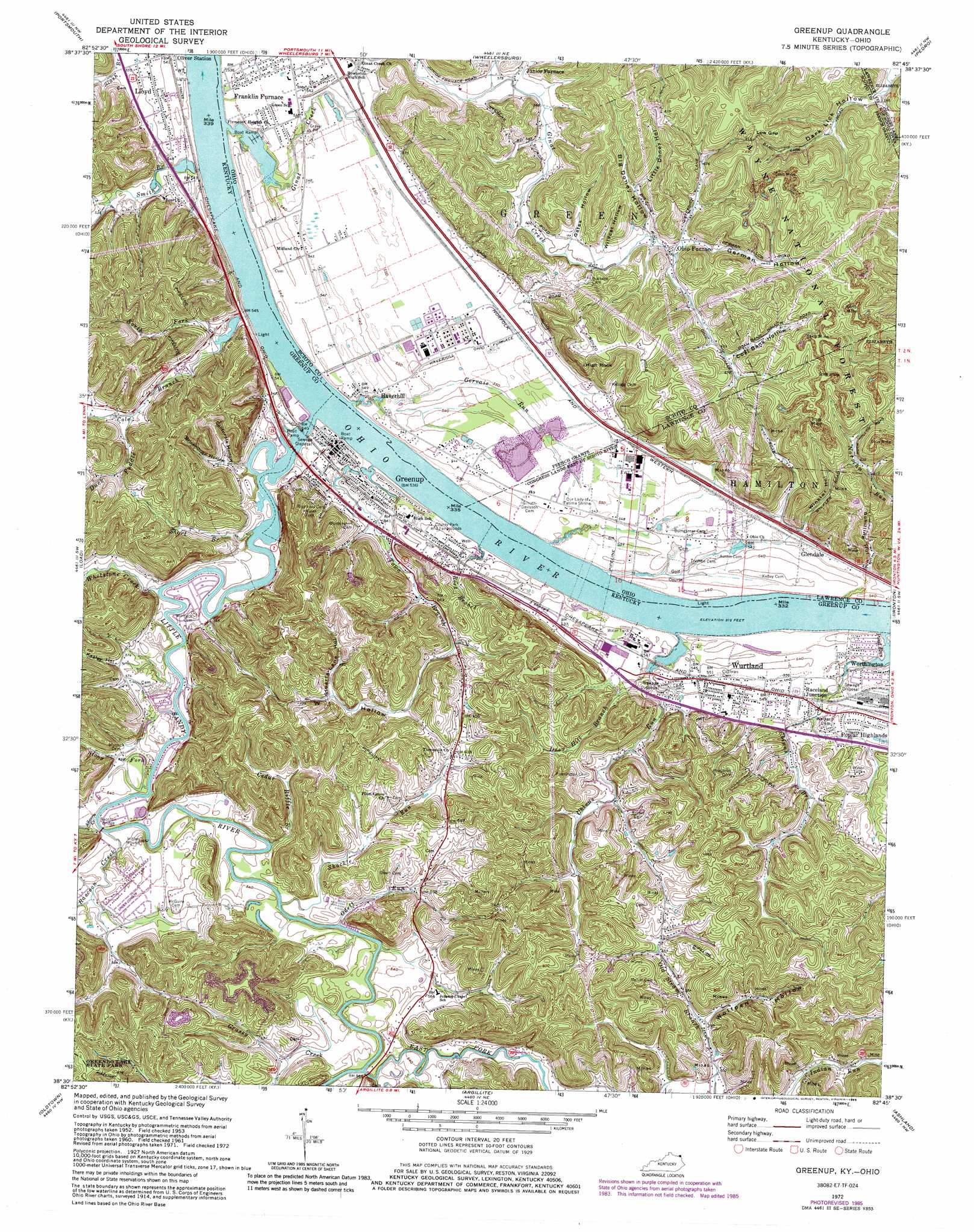
USGS Topo Quad 38082e7 - 1:24,000 scale
| Topo Map Name: | Greenup |
| USGS Topo Quad ID: | 38082e7 |
| Print Size: | ca. 21 1/4" wide x 27" high |
| Southeast Coordinates: | 38.5° N latitude / 82.75° W longitude |
| Map Center Coordinates: | 38.5625° N latitude / 82.8125° W longitude |
| U.S. States: | KY, OH |
| Filename: | o38082e7.jpg |
| Download Map JPG Image: | Greenup topo map 1:24,000 scale |
| Map Type: | Topographic |
| Topo Series: | 7.5´ |
| Map Scale: | 1:24,000 |
| Source of Map Images: | United States Geological Survey (USGS) |
| Alternate Map Versions: |
Greenup KY 1953, updated 1955 Download PDF Buy paper map Greenup KY 1958, updated 1959 Download PDF Buy paper map Greenup KY 1961, updated 1963 Download PDF Buy paper map Greenup KY 1972, updated 1973 Download PDF Buy paper map Greenup KY 1972, updated 1976 Download PDF Buy paper map Greenup KY 1972, updated 1985 Download PDF Buy paper map Greenup KY 2002, updated 2006 Download PDF Buy paper map Greenup KY 2011 Download PDF Buy paper map Greenup KY 2013 Download PDF Buy paper map Greenup KY 2016 Download PDF Buy paper map |
| FStopo: | US Forest Service topo Greenup is available: Download FStopo PDF Download FStopo TIF |
1:24,000 Topo Quads surrounding Greenup
West Portsmouth |
New Boston |
Minford |
South Webster |
Gallia |
Friendship |
Portsmouth |
Wheelersburg |
Pedro |
Sherritts |
Brushart |
Load |
Greenup |
Ironton |
Kitts Hill |
Tygarts Valley |
Oldtown |
Argillite |
Ashland |
Catlettsburg |
Grahn |
Grayson |
Rush |
Boltsfork |
Burnaugh |
> Back to 38082e1 at 1:100,000 scale
> Back to 38082a1 at 1:250,000 scale
> Back to U.S. Topo Maps home
Greenup topo map: Gazetteer
Greenup: Bridges
Raccoon Bridge elevation 159m 521′Greenup: Dams
Greenup Lock and Dam Number 30 (historical) elevation 156m 511′Greenup: Gaps
Low Gap elevation 256m 839′Greenup: Parks
Our Lady of Fatima Shrine elevation 166m 544′Greenup: Pillars
High Rock elevation 246m 807′Greenup: Populated Places
Glendale elevation 171m 561′Greenup elevation 160m 524′
Haverhill elevation 167m 547′
Junior Furnace elevation 174m 570′
Lloyd elevation 165m 541′
Ohio Furnace elevation 190m 623′
Oliver Station elevation 164m 538′
Poplar Highlands elevation 174m 570′
Raceland Junction elevation 168m 551′
Riverview Mobile Home Park elevation 167m 547′
Wurtland elevation 168m 551′
Greenup: Post Offices
Haverhill Post Office elevation 167m 547′Greenup: Streams
Allcorn Creek elevation 158m 518′Cedar Riffle Branch elevation 158m 518′
Chinns Branch elevation 157m 515′
Coal Branch elevation 154m 505′
Culp Creek elevation 160m 524′
Deer Hill Branch elevation 158m 518′
Duck Puddle elevation 170m 557′
East Fork Little Sandy River elevation 160m 524′
Gervais Run elevation 157m 515′
Ginat Creek elevation 158m 518′
Grassy Creek elevation 159m 521′
Little Sandy River elevation 158m 518′
North Fork Cole Branch elevation 155m 508′
Odett Run elevation 158m 518′
Pond Run elevation 156m 511′
Raccoon Creek elevation 158m 518′
Rock Branch elevation 158m 518′
Shackle Run elevation 158m 518′
Short Branch elevation 157m 515′
Smith Branch elevation 155m 508′
Stony Fork elevation 157m 515′
Town Branch elevation 157m 515′
Uhlens Run elevation 158m 518′
Whetstone Creek elevation 157m 515′
Greenup: Valleys
Big Doney Hollow elevation 199m 652′Bowman Hollow elevation 176m 577′
Brickhouse Hollow elevation 172m 564′
California Hollow elevation 172m 564′
Coal Bank Hollow elevation 209m 685′
Dark Lick Hollow elevation 178m 583′
Gates Hollow elevation 200m 656′
German Hollow elevation 193m 633′
Kagley Hollow elevation 176m 577′
Little Doney Hollow elevation 202m 662′
Schilling Hollow elevation 167m 547′
Stuarts Lane Hollow elevation 209m 685′
West Hollow elevation 192m 629′
Wildcat Hollow elevation 193m 633′
Winkler Hollow elevation 168m 551′
Wolfpen Hollow elevation 178m 583′
Greenup digital topo map on disk
Buy this Greenup topo map showing relief, roads, GPS coordinates and other geographical features, as a high-resolution digital map file on DVD:
Western Virginia & Southern West Virginia
Buy digital topo maps: Western Virginia & Southern West Virginia