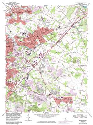
Moorestown Topo Map New Jersey
To zoom in, hover over the map of Moorestown
USGS Topo Quad 39074h8 - 1:24,000 scale
| Topo Map Name: | Moorestown |
| USGS Topo Quad ID: | 39074h8 |
| Print Size: | ca. 21 1/4" wide x 27" high |
| Southeast Coordinates: | 39.875° N latitude / 74.875° W longitude |
| Map Center Coordinates: | 39.9375° N latitude / 74.9375° W longitude |
| U.S. State: | NJ |
| Filename: | o39074h8.jpg |
| Download Map JPG Image: | Moorestown topo map 1:24,000 scale |
| Map Type: | Topographic |
| Topo Series: | 7.5´ |
| Map Scale: | 1:24,000 |
| Source of Map Images: | United States Geological Survey (USGS) |
| Alternate Map Versions: |
Moorestown NJ 1953, updated 1954 Download PDF Buy paper map Moorestown NJ 1953, updated 1965 Download PDF Buy paper map Moorestown NJ 1966, updated 1968 Download PDF Buy paper map Moorestown NJ 1966, updated 1982 Download PDF Buy paper map Moorestown NJ 1966, updated 1986 Download PDF Buy paper map Moorestown NJ 1995, updated 1998 Download PDF Buy paper map Moorestown NJ 2011 Download PDF Buy paper map Moorestown NJ 2014 Download PDF Buy paper map Moorestown NJ 2016 Download PDF Buy paper map |
1:24,000 Topo Quads surrounding Moorestown
> Back to 39074e1 at 1:100,000 scale
> Back to 39074a1 at 1:250,000 scale
> Back to U.S. Topo Maps home
Moorestown topo map: Gazetteer
Moorestown: Airports
A M Rodgers Construction Company elevation 17m 55′Bancshares Helistop elevation 10m 32′
Caputo Helistop elevation 23m 75′
Chemical Bank-New Jersey National Heliport elevation 10m 32′
Collins Field (historical) elevation 13m 42′
Griffin Associates Heliport elevation 21m 68′
New Jersey Turnpike Authority Heliport elevation 12m 39′
Moorestown: Dams
Strawbridge Lake Upper Dam elevation 4m 13′Moorestown: Parks
Mount Laurel State Park elevation 46m 150′Wood Park elevation 25m 82′
Moorestown: Populated Places
Barclay Farm elevation 13m 42′Birchfield elevation 10m 32′
Bougher elevation 18m 59′
Cambridge elevation 21m 68′
Candlewyck elevation 23m 75′
Charleston East elevation 23m 75′
Cherry Downs elevation 21m 68′
Cherry Valley elevation 14m 45′
Cinnaminson elevation 23m 75′
Colemantown elevation 24m 78′
Colestown elevation 24m 78′
Coxs Corner elevation 24m 78′
Cropwell elevation 28m 91′
Deer Park elevation 22m 72′
Deerwoods elevation 11m 36′
Donlontown elevation 31m 101′
Evans Corner elevation 30m 98′
Evesboro elevation 29m 95′
Fellowship elevation 15m 49′
Fox Hollow Woods elevation 21m 68′
Greenhaven elevation 17m 55′
Greentree elevation 31m 101′
Greentree Village elevation 29m 95′
Hartford elevation 13m 42′
Heritage Village elevation 22m 72′
Ivywood elevation 20m 65′
Kingston Estates elevation 11m 36′
Lenola elevation 9m 29′
Locust Grove elevation 28m 91′
Maple Shade elevation 17m 55′
Marlboro elevation 25m 82′
Marlton elevation 31m 101′
Moorestown elevation 23m 75′
Mount Laurel elevation 26m 85′
Northwood elevation 15m 49′
Pheasant Run elevation 12m 39′
Pine Grove elevation 18m 59′
Point of Woods elevation 25m 82′
Ramblewood elevation 9m 29′
Springdale elevation 27m 88′
Stanwick elevation 19m 62′
Stanwick Glen elevation 19m 62′
Stow Acres elevation 24m 78′
Surrey Place elevation 18m 59′
Texas elevation 11m 36′
The Maples elevation 31m 101′
Wellington Park elevation 14m 45′
West Moorestown elevation 21m 68′
Wexford East elevation 25m 82′
Willowdale elevation 23m 75′
Woodstream elevation 21m 68′
Wrightsville elevation 11m 36′
Moorestown: Reservoirs
Strawbridge Lake elevation 3m 9′Moorestown: Streams
Cropwell Branch elevation 18m 59′Parkers Creek elevation 1m 3′
Moorestown: Summits
Mount Laurel elevation 49m 160′Moorestown digital topo map on disk
Buy this Moorestown topo map showing relief, roads, GPS coordinates and other geographical features, as a high-resolution digital map file on DVD:
Atlantic Coast (NY, NJ, PA, DE, MD, VA, NC)
Buy digital topo maps: Atlantic Coast (NY, NJ, PA, DE, MD, VA, NC)


