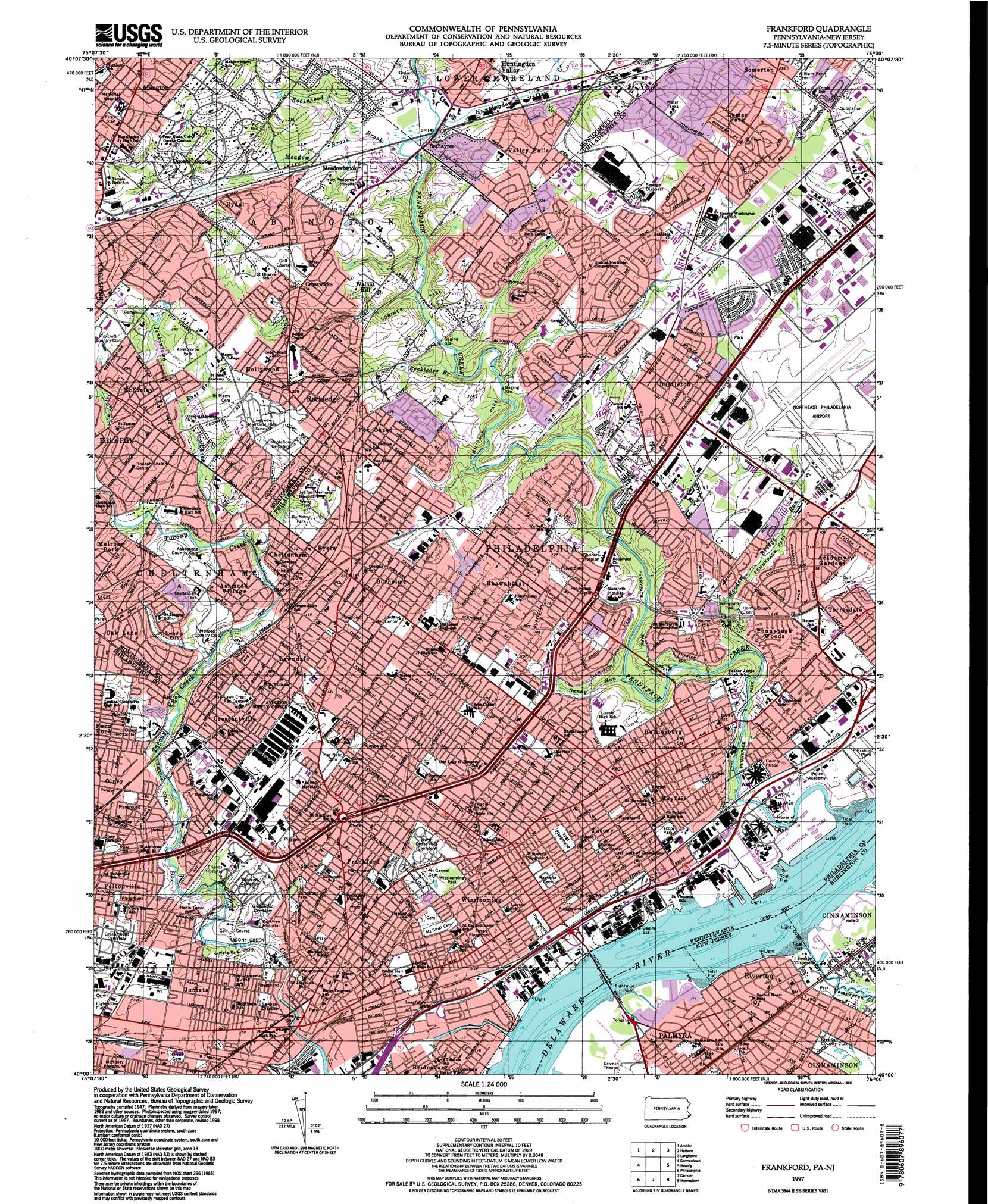
Frankford Topo Map Pennsylvania
To zoom in, hover over the map of Frankford
USGS Topo Quad 40075a1 - 1:24,000 scale
| Topo Map Name: | Frankford |
| USGS Topo Quad ID: | 40075a1 |
| Print Size: | ca. 21 1/4" wide x 27" high |
| Southeast Coordinates: | 40° N latitude / 75° W longitude |
| Map Center Coordinates: | 40.0625° N latitude / 75.0625° W longitude |
| U.S. States: | PA, NJ |
| Filename: | o40075a1.jpg |
| Download Map JPG Image: | Frankford topo map 1:24,000 scale |
| Map Type: | Topographic |
| Topo Series: | 7.5´ |
| Map Scale: | 1:24,000 |
| Source of Map Images: | United States Geological Survey (USGS) |
| Alternate Map Versions: |
Frankford PA 1950, updated 1953 Download PDF Buy paper map Frankford PA 1950, updated 1960 Download PDF Buy paper map Frankford PA 1967, updated 1970 Download PDF Buy paper map Frankford PA 1967, updated 1974 Download PDF Buy paper map Frankford PA 1967, updated 1983 Download PDF Buy paper map Frankford PA 1967, updated 1986 Download PDF Buy paper map Frankford PA 1967, updated 1986 Download PDF Buy paper map Frankford PA 1997, updated 1998 Download PDF Buy paper map Frankford PA 2011 Download PDF Buy paper map Frankford PA 2013 Download PDF Buy paper map Frankford PA 2016 Download PDF Buy paper map |
1:24,000 Topo Quads surrounding Frankford
Telford |
Doylestown |
Buckingham |
Lambertville |
Pennington |
Lansdale |
Ambler |
Hatboro |
Langhorne |
Trenton West |
Norristown |
Germantown |
Frankford |
Beverly |
Bristol |
Lansdowne |
Philadelphia |
Camden |
Moorestown |
Mount Holly |
Bridgeport |
Woodbury |
Runnemede |
Clementon |
Medford Lakes |
> Back to 40075a1 at 1:100,000 scale
> Back to 40074a1 at 1:250,000 scale
> Back to U.S. Topo Maps home
Frankford topo map: Gazetteer
Frankford: Airports
North Philadelphia Airport elevation 32m 104′Frankford: Bridges
Tacony-Palmyra Bridge elevation 0m 0′Frankford: Capes
Eightmile Point elevation 3m 9′Ten Mile Point elevation 0m 0′
Frankford: Channels
Bridesburg Channel elevation 0m 0′Frankford Channel elevation 0m 0′
Frankford Channel elevation 0m 0′
Tacony Channel elevation 0m 0′
Tacony Channel elevation 0m 0′
Frankford: Crossings
Interchange 27 elevation 12m 39′Interchange 30 elevation 6m 19′
Interchange 32 elevation 16m 52′
Pennsylvania Turnpike Interchange 10 elevation 80m 262′
Frankford: Dams
Debris Dam elevation 5m 16′Moreland Spring Dam elevation 33m 108′
Spring Dam elevation 33m 108′
Walker Dam elevation 30m 98′
Frankford: Parks
Abington Township Bird Sanctuary elevation 42m 137′Abington Township Game Preserve elevation 38m 124′
Alverthorpe Park elevation 79m 259′
Barnes and Loney Park elevation 67m 219′
Burholme Park elevation 54m 177′
Butler Township Park elevation 46m 150′
Cheltenham Township Park elevation 42m 137′
Disston Park elevation 11m 36′
Foss Playground elevation 12m 39′
Fox Chase Playground elevation 61m 200′
Foxchase Manor Park elevation 67m 219′
Frankford Playground elevation 17m 55′
Frankford Stadium elevation 28m 91′
Hayes Playground elevation 42m 137′
James Ramp Memorial Recreation Center elevation 21m 68′
Jardel Playground elevation 41m 134′
Juniata Park elevation 16m 52′
Lawncrest Playground elevation 44m 144′
Lorimer Park elevation 34m 111′
Max Myers Playground elevation 31m 101′
Melrose Park elevation 59m 193′
Northwood Park elevation 22m 72′
Ogontz Field elevation 43m 141′
Olney Playground elevation 39m 127′
Pennypack Park elevation 8m 26′
Philmont Park elevation 40m 131′
Roosevelt Playground elevation 15m 49′
Roosevelt Racquet Club elevation 73m 239′
Swensen Park elevation 42m 137′
Swenson Park elevation 45m 147′
Tacony Creek Park elevation 9m 29′
Tacony Park elevation 10m 32′
Tarken Playground elevation 30m 98′
Valley Park elevation 44m 144′
Vogt Playground elevation 17m 55′
Webster Playground elevation 13m 42′
White Hall Commons elevation 10m 32′
Wissinoming Park elevation 18m 59′
Ziehler Playground elevation 42m 137′
Frankford: Populated Places
Abington elevation 104m 341′Ashmead Village elevation 38m 124′
Ashton Wooden Bridge elevation 27m 88′
Bethayres elevation 44m 144′
Blue Grass elevation 35m 114′
Bridesburg elevation 6m 19′
Burholme elevation 46m 150′
Bustleton elevation 41m 134′
Cedar Grove elevation 34m 111′
Chapel Hill Manor elevation 67m 219′
Cheltenham elevation 39m 127′
Cheltenham Village elevation 36m 118′
Coventry House elevation 51m 167′
Crescentville elevation 41m 134′
Crosswicks elevation 71m 232′
Elkins Park Gardens elevation 52m 170′
Fitler elevation 4m 13′
Fox Chase elevation 65m 213′
Foxcroft Square elevation 89m 291′
Frankford elevation 27m 88′
Gloria Dei Towers elevation 44m 144′
Harrisburg elevation 23m 75′
High Rue elevation 30m 98′
Hollywood elevation 73m 239′
Holme Circle elevation 32m 104′
Holmesburg elevation 25m 82′
Huntingdon Valley elevation 50m 164′
Juniata elevation 25m 82′
Lagrange elevation 23m 75′
Lawn Crest elevation 37m 121′
Lawncrest elevation 40m 131′
Lawndale elevation 40m 131′
Lexington Park elevation 30m 98′
Mayfair elevation 19m 62′
McKinley elevation 80m 262′
Meadowbrook elevation 47m 154′
Noble elevation 69m 226′
Northwood elevation 26m 85′
Oak Lane elevation 66m 216′
Oak Lane Manor elevation 43m 141′
Oaklane elevation 65m 213′
Olney elevation 46m 150′
Oxford Circle elevation 36m 118′
Oxford Village elevation 35m 114′
Palmyra elevation 3m 9′
Pauls Run elevation 45m 147′
Pennypack elevation 27m 88′
Pennypack Woods elevation 20m 65′
Philmont elevation 66m 216′
Rhawnhurst elevation 37m 121′
Riverton elevation 3m 9′
Rockledge elevation 74m 242′
Rydal elevation 68m 223′
Rydal East elevation 57m 187′
Rydal Estates elevation 68m 223′
Rydal Green elevation 84m 275′
Rydal Park elevation 63m 206′
Rydall Park elevation 55m 180′
Ryers elevation 43m 141′
Somerton elevation 69m 226′
Summerdale elevation 30m 98′
Tacony elevation 22m 72′
Torresdale elevation 24m 78′
Upper Holmesburg elevation 17m 55′
Valley Falls elevation 75m 246′
Vereeville elevation 35m 114′
Volunteertown elevation 34m 111′
Walnut Hill elevation 60m 196′
Winchester Park elevation 32m 104′
Wissinoming elevation 20m 65′
Wyndmoor Estates elevation 59m 193′
Frankford: Post Offices
Boulevard Station Post Office elevation 26m 85′Bustleton Station Post Office elevation 48m 157′
Castor Avenue Post Office elevation 31m 101′
Fox Chase Station Post Office elevation 44m 144′
Holmesburg Finance Station Post Office elevation 18m 59′
Huntingdon Valley Post Office elevation 41m 134′
Mayfair Post Office elevation 29m 95′
Olney Station Post Office elevation 41m 134′
Rydal Branch Post Office elevation 48m 157′
Tacony Post Office elevation 17m 55′
Welsh Road Post Office elevation 37m 121′
Frankford: Reservoirs
Moreland Pond elevation 33m 108′Frankford: Streams
East Branch Jenkintown Creek elevation 59m 193′Huntingdon Valley Creek elevation 33m 108′
Jenkintown Creek elevation 33m 108′
Little Tacony Creek (historical) elevation 36m 118′
Meadow Brook elevation 32m 104′
Mill Run elevation 35m 114′
Pennypack Creek elevation 0m 0′
Pompeston Creek elevation 3m 9′
Robinhood Brook elevation 33m 108′
Rockledge Branch elevation 0m 0′
Sandy Run elevation 9m 29′
Tacony Creek elevation 21m 68′
Wissinoming Creek (historical) elevation 28m 91′
Wooden Bridge Run elevation 6m 19′
Frankford digital topo map on disk
Buy this Frankford topo map showing relief, roads, GPS coordinates and other geographical features, as a high-resolution digital map file on DVD:
Atlantic Coast (NY, NJ, PA, DE, MD, VA, NC)
Buy digital topo maps: Atlantic Coast (NY, NJ, PA, DE, MD, VA, NC)
 map DVD")