Wakefield Topo Map Pennsylvania
To zoom in, hover over the map of Wakefield
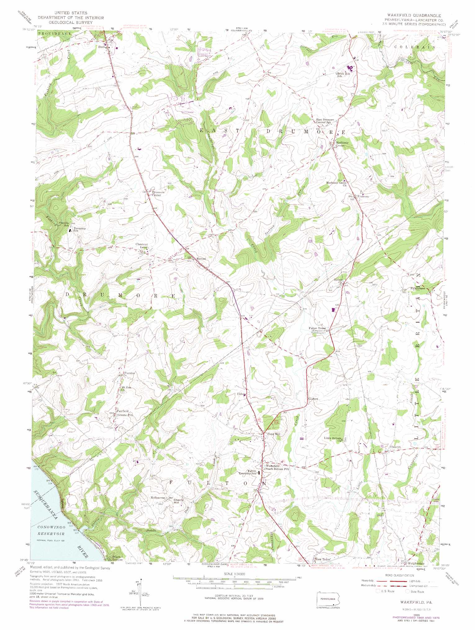
USGS Topo Quad 39076g2 - 1:24,000 scale
| Topo Map Name: | Wakefield |
| USGS Topo Quad ID: | 39076g2 |
| Print Size: | ca. 21 1/4" wide x 27" high |
| Southeast Coordinates: | 39.75° N latitude / 76.125° W longitude |
| Map Center Coordinates: | 39.8125° N latitude / 76.1875° W longitude |
| U.S. State: | PA |
| Filename: | o39076g2.jpg |
| Download Map JPG Image: | Wakefield topo map 1:24,000 scale |
| Map Type: | Topographic |
| Topo Series: | 7.5´ |
| Map Scale: | 1:24,000 |
| Source of Map Images: | United States Geological Survey (USGS) |
| Alternate Map Versions: |
Wakefield PA 1955 Download PDF Buy paper map Wakefield PA 1955, updated 1956 Download PDF Buy paper map Wakefield PA 1955, updated 1965 Download PDF Buy paper map Wakefield PA 1955, updated 1971 Download PDF Buy paper map Wakefield PA 1955, updated 1977 Download PDF Buy paper map Wakefield PA 1999, updated 2001 Download PDF Buy paper map Wakefield PA 2010 Download PDF Buy paper map Wakefield PA 2013 Download PDF Buy paper map Wakefield PA 2016 Download PDF Buy paper map |
1:24,000 Topo Quads surrounding Wakefield
Columbia East |
Lancaster |
Leola |
New Holland |
Honey Brook |
Safe Harbor |
Conestoga |
Quarryville |
Gap |
Parkesburg |
Airville |
Holtwood |
Wakefield |
Kirkwood |
Oxford |
Fawn Grove |
Delta |
Conowingo Dam |
Rising Sun |
Bay View |
Jarrettsville |
Bel Air |
Aberdeen |
Havre De Grace |
North East |
> Back to 39076e1 at 1:100,000 scale
> Back to 39076a1 at 1:250,000 scale
> Back to U.S. Topo Maps home
Wakefield topo map: Gazetteer
Wakefield: Airports
Little Britain Airport elevation 122m 400′Rohrer Airport elevation 174m 570′
Tanglewood Airport elevation 197m 646′
Wakefield: Populated Places
Bethel elevation 148m 485′Buck elevation 216m 708′
Chestnut Level elevation 171m 561′
Drumore Center elevation 179m 587′
Eldora elevation 121m 396′
Fairfiled elevation 135m 442′
Fairmount elevation 158m 518′
Furniss elevation 126m 413′
Goshen elevation 114m 374′
Hensel elevation 190m 623′
McSparran elevation 107m 351′
Mechanic Grove elevation 194m 636′
Oakryn elevation 124m 406′
Peach Bottom elevation 43m 141′
Penn Hill elevation 134m 439′
Unicorn elevation 180m 590′
Wakefield elevation 119m 390′
Wrightsdale elevation 136m 446′
Wakefield: Post Offices
Buck Post Office (historical) elevation 216m 708′Chestnut Level Post Office (historical) elevation 171m 561′
Fulton House Post Office (historical) elevation 122m 400′
Goshen Post Office (historical) elevation 114m 374′
Greene Post Office elevation 135m 442′
Mechanics Grove Post Office (historical) elevation 194m 636′
Peach Botton Post Office elevation 119m 390′
Wakefield Post Office (historical) elevation 119m 390′
Wrightsdale Post Office (historical) elevation 136m 446′
Wakefield: Streams
Jackson Run elevation 119m 390′Little Conowingo Creek elevation 93m 305′
McFarlands Run elevation 131m 429′
Peters Creek elevation 30m 98′
Puddle Duck Creek elevation 40m 131′
Wakefield: Summits
Cherry Hill elevation 111m 364′Wakefield digital topo map on disk
Buy this Wakefield topo map showing relief, roads, GPS coordinates and other geographical features, as a high-resolution digital map file on DVD:
Atlantic Coast (NY, NJ, PA, DE, MD, VA, NC)
Buy digital topo maps: Atlantic Coast (NY, NJ, PA, DE, MD, VA, NC)
 map DVD")