Lonaconing Topo Map Maryland
To zoom in, hover over the map of Lonaconing
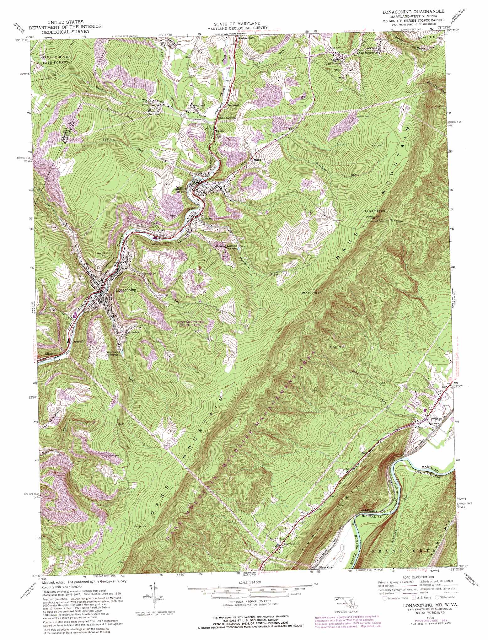
USGS Topo Quad 39078e8 - 1:24,000 scale
| Topo Map Name: | Lonaconing |
| USGS Topo Quad ID: | 39078e8 |
| Print Size: | ca. 21 1/4" wide x 27" high |
| Southeast Coordinates: | 39.5° N latitude / 78.875° W longitude |
| Map Center Coordinates: | 39.5625° N latitude / 78.9375° W longitude |
| U.S. States: | MD, WV |
| Filename: | o39078e8.jpg |
| Download Map JPG Image: | Lonaconing topo map 1:24,000 scale |
| Map Type: | Topographic |
| Topo Series: | 7.5´ |
| Map Scale: | 1:24,000 |
| Source of Map Images: | United States Geological Survey (USGS) |
| Alternate Map Versions: |
Lonaconing MD 1950, updated 1968 Download PDF Buy paper map Lonaconing MD 1950, updated 1975 Download PDF Buy paper map Lonaconing MD 1950, updated 1982 Download PDF Buy paper map Lonaconing MD 1951 Download PDF Buy paper map Lonaconing MD 1951, updated 1951 Download PDF Buy paper map Lonaconing MD 1998, updated 1999 Download PDF Buy paper map Lonaconing MD 2011 Download PDF Buy paper map Lonaconing MD 2014 Download PDF Buy paper map Lonaconing MD 2016 Download PDF Buy paper map |
1:24,000 Topo Quads surrounding Lonaconing
Markleton |
Meyersdale |
Wittenberg |
Fairhope |
Hyndman |
Grantsville |
Avilton |
Frostburg |
Cumberland |
Evitts Creek |
Bittinger |
Barton |
Lonaconing |
Cresaptown |
Patterson Creek |
Kitzmiller |
Westernport |
Keyser |
Headsville |
Springfield |
Mount Storm |
Antioch |
Burlington |
Romney |
Augusta |
> Back to 39078e1 at 1:100,000 scale
> Back to 39078a1 at 1:250,000 scale
> Back to U.S. Topo Maps home
Lonaconing topo map: Gazetteer
Lonaconing: Capes
Squirrel Neck elevation 678m 2224′Lonaconing: Parks
Dans Mountain State Park elevation 677m 2221′Dans Mountain Wildlife Management Area elevation 566m 1856′
Lonaconing Historic District elevation 465m 1525′
Lonaconing: Populated Places
Bier elevation 226m 741′Carlos elevation 605m 1984′
Carlos Junction elevation 562m 1843′
Charlestown elevation 513m 1683′
Danville elevation 335m 1099′
Detmold elevation 437m 1433′
Gilmore elevation 512m 1679′
Klondike elevation 577m 1893′
Koontz elevation 543m 1781′
Loarville elevation 639m 2096′
Lonaconing elevation 454m 1489′
Midland elevation 522m 1712′
Miller elevation 558m 1830′
National elevation 545m 1788′
Nikep elevation 423m 1387′
Ocean elevation 542m 1778′
Porters (historical) elevation 220m 721′
Rawlings elevation 226m 741′
Rawlings Heights elevation 252m 826′
Vale Summit elevation 619m 2030′
Woodland elevation 539m 1768′
Lonaconing: Post Offices
Lonaconing Post Office elevation 461m 1512′Midland Post Office elevation 520m 1706′
Rawlings Post Office elevation 221m 725′
Lonaconing: Reservoirs
Lonaconing Reservoir elevation 549m 1801′Midland-Gilmore Reservoir elevation 579m 1899′
Lonaconing: Streams
Ashcabin Run elevation 213m 698′Elklick Run elevation 507m 1663′
Hill Run elevation 479m 1571′
Jackson Run elevation 451m 1479′
Koontz Run elevation 457m 1499′
Matthew Run elevation 600m 1968′
Neff Run elevation 520m 1706′
Squirrel Neck Run elevation 515m 1689′
Staub Run elevation 531m 1742′
Vale Run elevation 527m 1729′
Winebrenner Run elevation 536m 1758′
Woodland Creek elevation 552m 1811′
Lonaconing: Summits
Dans Mountain elevation 873m 2864′Dans Rock elevation 864m 2834′
Fairview elevation 823m 2700′
Fort Hill elevation 481m 1578′
Fox Hill elevation 527m 1729′
Jackson Mountain elevation 650m 2132′
Wolf Rock elevation 834m 2736′
Lonaconing digital topo map on disk
Buy this Lonaconing topo map showing relief, roads, GPS coordinates and other geographical features, as a high-resolution digital map file on DVD:
 map DVD")