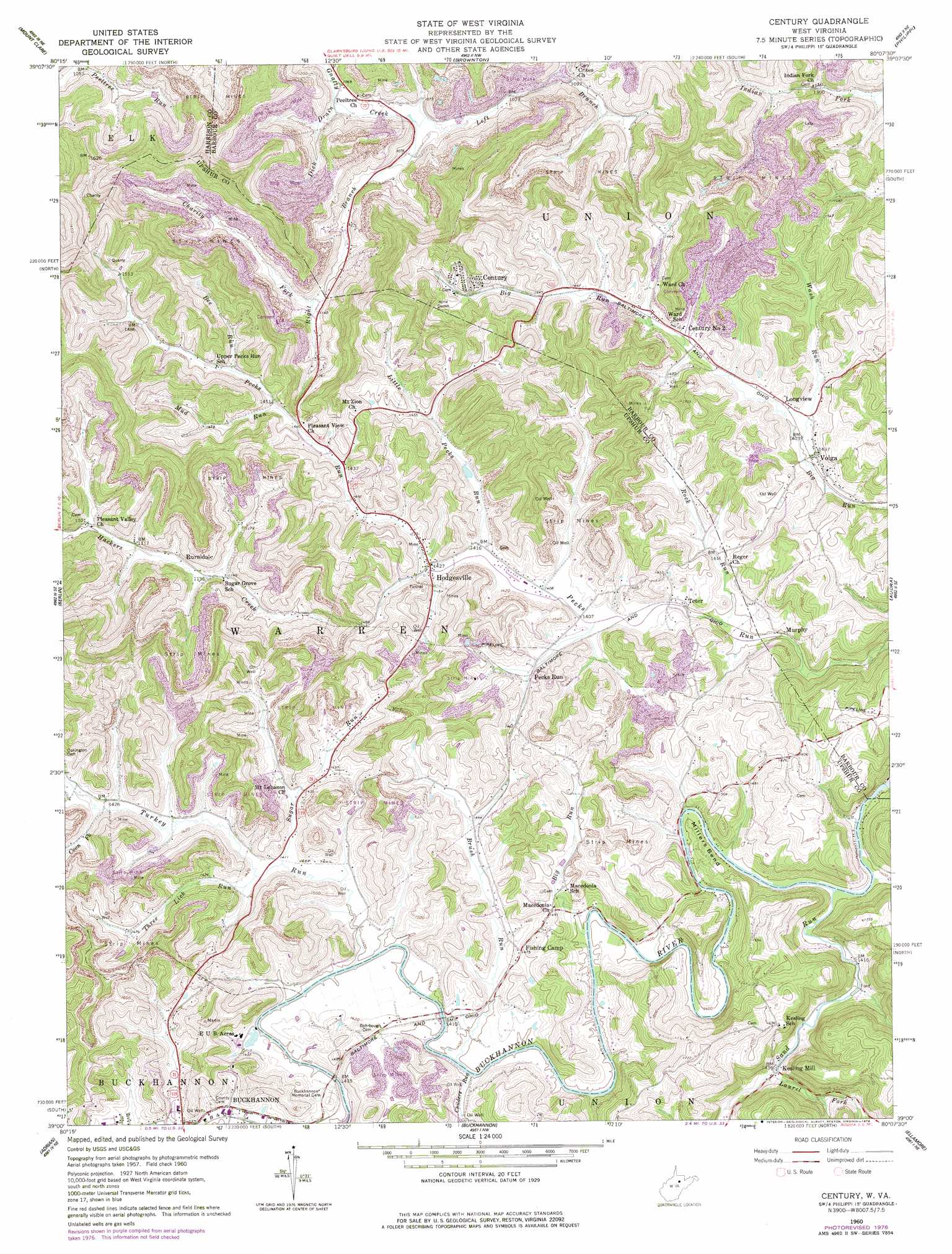
Century Topo Map West Virginia
To zoom in, hover over the map of Century
USGS Topo Quad 39080a2 - 1:24,000 scale
| Topo Map Name: | Century |
| USGS Topo Quad ID: | 39080a2 |
| Print Size: | ca. 21 1/4" wide x 27" high |
| Southeast Coordinates: | 39° N latitude / 80.125° W longitude |
| Map Center Coordinates: | 39.0625° N latitude / 80.1875° W longitude |
| U.S. State: | WV |
| Filename: | o39080a2.jpg |
| Download Map JPG Image: | Century topo map 1:24,000 scale |
| Map Type: | Topographic |
| Topo Series: | 7.5´ |
| Map Scale: | 1:24,000 |
| Source of Map Images: | United States Geological Survey (USGS) |
| Alternate Map Versions: |
Century WV 1960, updated 1961 Download PDF Buy paper map Century WV 1960, updated 1966 Download PDF Buy paper map Century WV 1960, updated 1978 Download PDF Buy paper map Century WV 2011 Download PDF Buy paper map Century WV 2014 Download PDF Buy paper map Century WV 2016 Download PDF Buy paper map |
1:24,000 Topo Quads surrounding Century
Wolf Summit |
Clarksburg |
Rosemont |
Grafton |
Thornton |
West Milford |
Mount Clare |
Brownton |
Philippi |
Nestorville |
Weston |
Berlin |
Century |
Audra |
Belington |
Roanoke |
Adrian |
Buckhannon |
Ellamore |
Junior |
Walkersville |
Rock Cave |
Alton |
Cassity |
Beverly West |
> Back to 39080a1 at 1:100,000 scale
> Back to 39080a1 at 1:250,000 scale
> Back to U.S. Topo Maps home
Century topo map: Gazetteer
Century: Bends
Millers Bend elevation 444m 1456′Century: Crossings
Wentz Ford elevation 429m 1407′Century: Populated Places
Century elevation 467m 1532′Hodgesville elevation 434m 1423′
Kesling Mill elevation 436m 1430′
Longview elevation 432m 1417′
Murphy elevation 427m 1400′
Pecks Run elevation 441m 1446′
Ruraldale elevation 362m 1187′
Simons (historical) elevation 414m 1358′
Teter elevation 430m 1410′
Volga elevation 436m 1430′
Century: Post Offices
Century Post Office elevation 475m 1558′Century: Springs
Century Number One Cummunity Spring elevation 464m 1522′Century: Streams
Bee Run elevation 442m 1450′Big Run elevation 424m 1391′
Brush Run elevation 426m 1397′
Charity Fork elevation 338m 1108′
Childers Run elevation 426m 1397′
Coon Fork elevation 434m 1423′
Cranes Fork elevation 330m 1082′
Dick Drain elevation 320m 1049′
Handy Camp Run elevation 424m 1391′
Laurel Fork Sand Run elevation 438m 1437′
Left Branch Gnatty Creek elevation 320m 1049′
Little Laurel Fork elevation 456m 1496′
Little Pecks Run elevation 431m 1414′
Mud Run elevation 440m 1443′
Right Branch Gnatty Creek elevation 320m 1049′
Rock Run elevation 428m 1404′
Sand Run elevation 424m 1391′
Sugar Run elevation 428m 1404′
Three Lick Run elevation 428m 1404′
Turkey Run elevation 426m 1397′
Wash Run elevation 426m 1397′
Century digital topo map on disk
Buy this Century topo map showing relief, roads, GPS coordinates and other geographical features, as a high-resolution digital map file on DVD:
 map DVD")