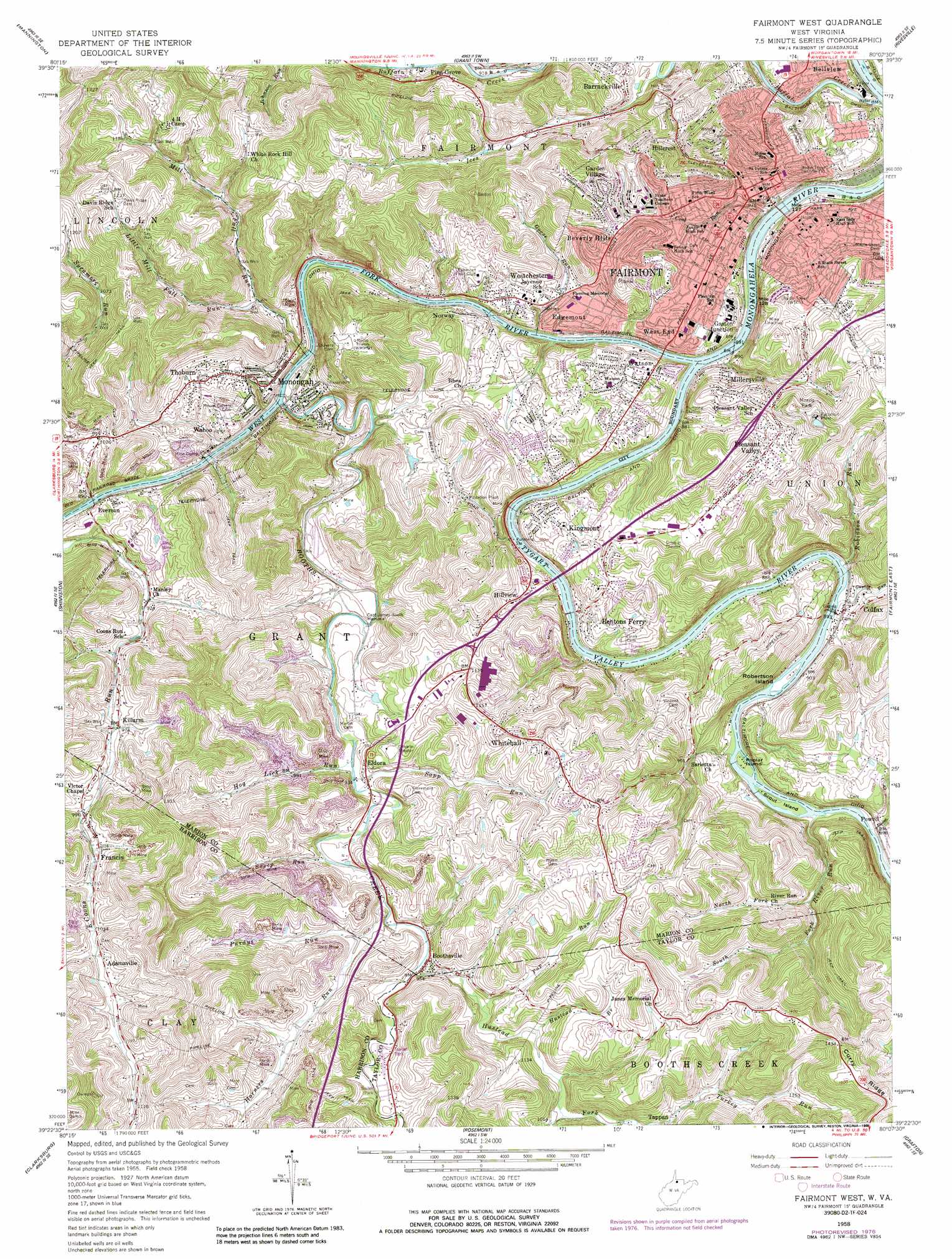
Fairmont West Topo Map West Virginia
To zoom in, hover over the map of Fairmont West
USGS Topo Quad 39080d2 - 1:24,000 scale
| Topo Map Name: | Fairmont West |
| USGS Topo Quad ID: | 39080d2 |
| Print Size: | ca. 21 1/4" wide x 27" high |
| Southeast Coordinates: | 39.375° N latitude / 80.125° W longitude |
| Map Center Coordinates: | 39.4375° N latitude / 80.1875° W longitude |
| U.S. State: | WV |
| Filename: | o39080d2.jpg |
| Download Map JPG Image: | Fairmont West topo map 1:24,000 scale |
| Map Type: | Topographic |
| Topo Series: | 7.5´ |
| Map Scale: | 1:24,000 |
| Source of Map Images: | United States Geological Survey (USGS) |
| Alternate Map Versions: |
Fairmont West WV 1958, updated 1960 Download PDF Buy paper map Fairmont West WV 1958, updated 1970 Download PDF Buy paper map Fairmont West WV 1958, updated 1977 Download PDF Buy paper map Fairmont West WV 1958, updated 1988 Download PDF Buy paper map Fairmont West WV 1997, updated 2002 Download PDF Buy paper map Fairmont West WV 2011 Download PDF Buy paper map Fairmont West WV 2014 Download PDF Buy paper map Fairmont West WV 2016 Download PDF Buy paper map |
1:24,000 Topo Quads surrounding Fairmont West
Hundred |
Wadestown |
Blacksville |
Osage |
Morgantown North |
Glover Gap |
Mannington |
Grant Town |
Rivesville |
Morgantown South |
Wallace |
Shinnston |
Fairmont West |
Fairmont East |
Gladesville |
Wolf Summit |
Clarksburg |
Rosemont |
Grafton |
Thornton |
West Milford |
Mount Clare |
Brownton |
Philippi |
Nestorville |
> Back to 39080a1 at 1:100,000 scale
> Back to 39080a1 at 1:250,000 scale
> Back to U.S. Topo Maps home
Fairmont West topo map: Gazetteer
Fairmont West: Airports
Fairmont Municipal Airport elevation 309m 1013′Fairmont West: Bridges
Million Dollar Bridge elevation 263m 862′Fairmont West: Crossings
Interchange 132 elevation 321m 1053′Interchange 133 elevation 310m 1017′
Interchange 135 elevation 328m 1076′
Fairmont West: Dams
Dick Harbert Lake Dam elevation 340m 1115′Fairmont West: Islands
Poplar Island elevation 269m 882′Robertson Island elevation 265m 869′
Scout Island elevation 266m 872′
Fairmont West: Parks
Captain James Booth Memorial elevation 278m 912′Fairmont East-West Stadium elevation 305m 1000′
Mary Lou Retton Park elevation 304m 997′
Morris Park elevation 389m 1276′
Twelfth Street Municipal Swimming Pool elevation 303m 994′
Windmill Park elevation 319m 1046′
Fairmont West: Populated Places
Adamsville elevation 321m 1053′Bellview elevation 305m 1000′
Bendolph elevation 273m 895′
Bentons Ferry elevation 307m 1007′
Beverly Hills elevation 350m 1148′
Boothsville elevation 293m 961′
Buffalo Station (historical) elevation 268m 879′
Colfax elevation 274m 898′
Edgemont elevation 292m 958′
Eldora elevation 295m 967′
Everson elevation 278m 912′
Fairmont elevation 300m 984′
Francis elevation 310m 1017′
Garden Village elevation 321m 1053′
Gaston elevation 302m 990′
Gaston Junction elevation 271m 889′
Hillcrest elevation 315m 1033′
Hillview elevation 296m 971′
Jayenn elevation 300m 984′
Killarm elevation 297m 974′
Kingmont elevation 296m 971′
Millersville elevation 330m 1082′
Monongah elevation 293m 961′
New England elevation 320m 1049′
Norway elevation 271m 889′
Palatine elevation 306m 1003′
Pettyjohn (historical) elevation 300m 984′
Pleasant Valley elevation 314m 1030′
Shagtown elevation 306m 1003′
Tappan elevation 321m 1053′
Thoburn elevation 304m 997′
Vernon Heights elevation 346m 1135′
Wahoo elevation 272m 892′
Watson elevation 294m 964′
West End elevation 313m 1026′
Westchester elevation 299m 980′
White Hall elevation 354m 1161′
Fairmont West: Post Offices
Colfax Post Office elevation 275m 902′East Side Station Fairmont Post Office elevation 291m 954′
Fairmont Post Office elevation 300m 984′
Kingmont Post Office elevation 296m 971′
Fairmont West: Springs
Andrew Hauges Nursery Spring elevation 284m 931′Edgar Ice Spring elevation 286m 938′
Glasspel Spring elevation 325m 1066′
Herchel Ice Spring elevation 273m 895′
Michael Spring elevation 296m 971′
Worthington Spring elevation 352m 1154′
Fairmont West: Streams
Booths Creek elevation 264m 866′Buffalo Creek elevation 262m 859′
Coal Run elevation 271m 889′
Fairmont Run elevation 269m 882′
Goose Creek elevation 268m 879′
Goose Run elevation 264m 866′
Guyses Run elevation 264m 866′
Hog Lick Run elevation 281m 921′
Horners Run elevation 286m 938′
Hustead Branch elevation 297m 974′
Hustead Fork elevation 288m 944′
Little Mill Fall Run elevation 281m 921′
Mill Fall Run elevation 264m 866′
Moody Run elevation 274m 898′
North Fork River Run elevation 300m 984′
Pup Run elevation 295m 967′
Purdys Run elevation 304m 997′
River Run elevation 266m 872′
Robinson Run elevation 264m 866′
Sapp Run elevation 281m 921′
South Fork River Run elevation 311m 1020′
Sweep Run elevation 285m 935′
Tygart Valley River elevation 263m 862′
West Fork River elevation 263m 862′
Fairmont West digital topo map on disk
Buy this Fairmont West topo map showing relief, roads, GPS coordinates and other geographical features, as a high-resolution digital map file on DVD:
 map DVD")