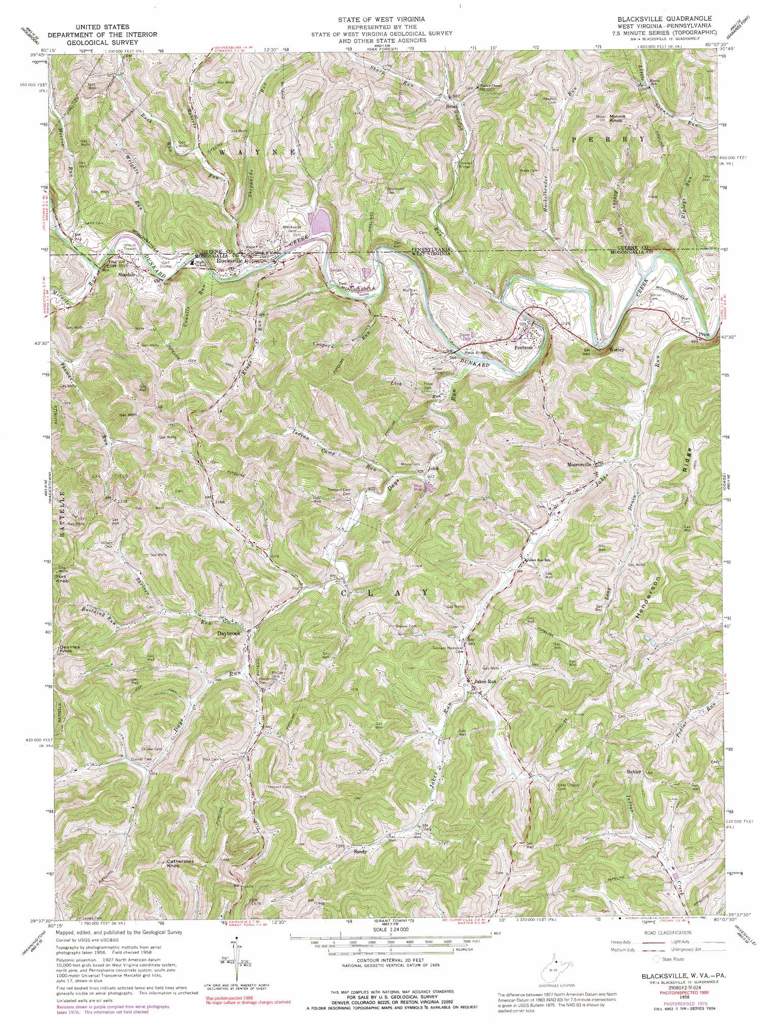
Blacksville Topo Map West Virginia
To zoom in, hover over the map of Blacksville
USGS Topo Quad 39080f2 - 1:24,000 scale
| Topo Map Name: | Blacksville |
| USGS Topo Quad ID: | 39080f2 |
| Print Size: | ca. 21 1/4" wide x 27" high |
| Southeast Coordinates: | 39.625° N latitude / 80.125° W longitude |
| Map Center Coordinates: | 39.6875° N latitude / 80.1875° W longitude |
| U.S. States: | WV, PA |
| Filename: | o39080f2.jpg |
| Download Map JPG Image: | Blacksville topo map 1:24,000 scale |
| Map Type: | Topographic |
| Topo Series: | 7.5´ |
| Map Scale: | 1:24,000 |
| Source of Map Images: | United States Geological Survey (USGS) |
| Alternate Map Versions: |
Blacksville WV 1958, updated 1962 Download PDF Buy paper map Blacksville WV 1958, updated 1973 Download PDF Buy paper map Blacksville WV 1958, updated 1977 Download PDF Buy paper map Blacksville WV 1958, updated 1992 Download PDF Buy paper map Blacksville WV 2011 Download PDF Buy paper map Blacksville WV 2014 Download PDF Buy paper map Blacksville WV 2016 Download PDF Buy paper map |
1:24,000 Topo Quads surrounding Blacksville
Wind Ridge |
Rogersville |
Waynesburg |
Mather |
Carmichaels |
New Freeport |
Holbrook |
Oak Forest |
Garards Fort |
Masontown |
Hundred |
Wadestown |
Blacksville |
Osage |
Morgantown North |
Glover Gap |
Mannington |
Grant Town |
Rivesville |
Morgantown South |
Wallace |
Shinnston |
Fairmont West |
Fairmont East |
Gladesville |
> Back to 39080e1 at 1:100,000 scale
> Back to 39080a1 at 1:250,000 scale
> Back to U.S. Topo Maps home
Blacksville topo map: Gazetteer
Blacksville: Bridges
Minor Bridge elevation 282m 925′Blacksville: Cliffs
The Cliff elevation 336m 1102′Blacksville: Dams
Mount Harmon Dam elevation 341m 1118′Blacksville: Populated Places
Behler elevation 414m 1358′Blacksville elevation 300m 984′
Brock elevation 300m 984′
Daybrook elevation 307m 1007′
Jakes Run elevation 308m 1010′
Macdale elevation 303m 994′
Mooresville elevation 292m 958′
Pentress elevation 290m 951′
Price elevation 290m 951′
Sandy elevation 332m 1089′
Worley elevation 283m 928′
Blacksville: Ridges
Henderson Ridge elevation 447m 1466′Blacksville: Springs
Burl Spragg Spring elevation 358m 1174′Cam Harker Spring elevation 314m 1030′
Husk Spring elevation 338m 1108′
James Hillberry Spring elevation 371m 1217′
Ralph Eddy Spring elevation 420m 1377′
Sherman Wright Spring elevation 360m 1181′
Tennant Spring elevation 400m 1312′
Tom Walker Spring elevation 381m 1250′
Blacksville: Streams
Blacks Run elevation 277m 908′Blacks Run elevation 277m 908′
Building Run elevation 322m 1056′
Coopers Run elevation 285m 935′
Cowells Run elevation 290m 951′
Days Run elevation 283m 928′
Hackelbender Run elevation 278m 912′
Huckleberry Run elevation 278m 912′
Indian Camp Run elevation 292m 958′
Jakes Run elevation 277m 908′
Kings Run elevation 286m 938′
Lick Run elevation 285m 935′
Long Drain elevation 287m 941′
Miracle Run elevation 296m 971′
Morris Run elevation 290m 951′
Ripleys Run elevation 295m 967′
Roberts Run elevation 286m 938′
Rudolf Run elevation 281m 921′
Rudolph Run elevation 281m 921′
Rush Run elevation 301m 987′
Sharp Run elevation 298m 977′
Sheppards Run elevation 290m 951′
Sheppards Run elevation 286m 938′
Shriver Run elevation 305m 1000′
Wrights Run elevation 290m 951′
Blacksville: Summits
Catherines Knob elevation 522m 1712′Devines Knob elevation 488m 1601′
Fort Knob elevation 481m 1578′
Minnie Knob elevation 484m 1587′
Blacksville digital topo map on disk
Buy this Blacksville topo map showing relief, roads, GPS coordinates and other geographical features, as a high-resolution digital map file on DVD:
 map DVD")