Rivesville Topo Map West Virginia
To zoom in, hover over the map of Rivesville
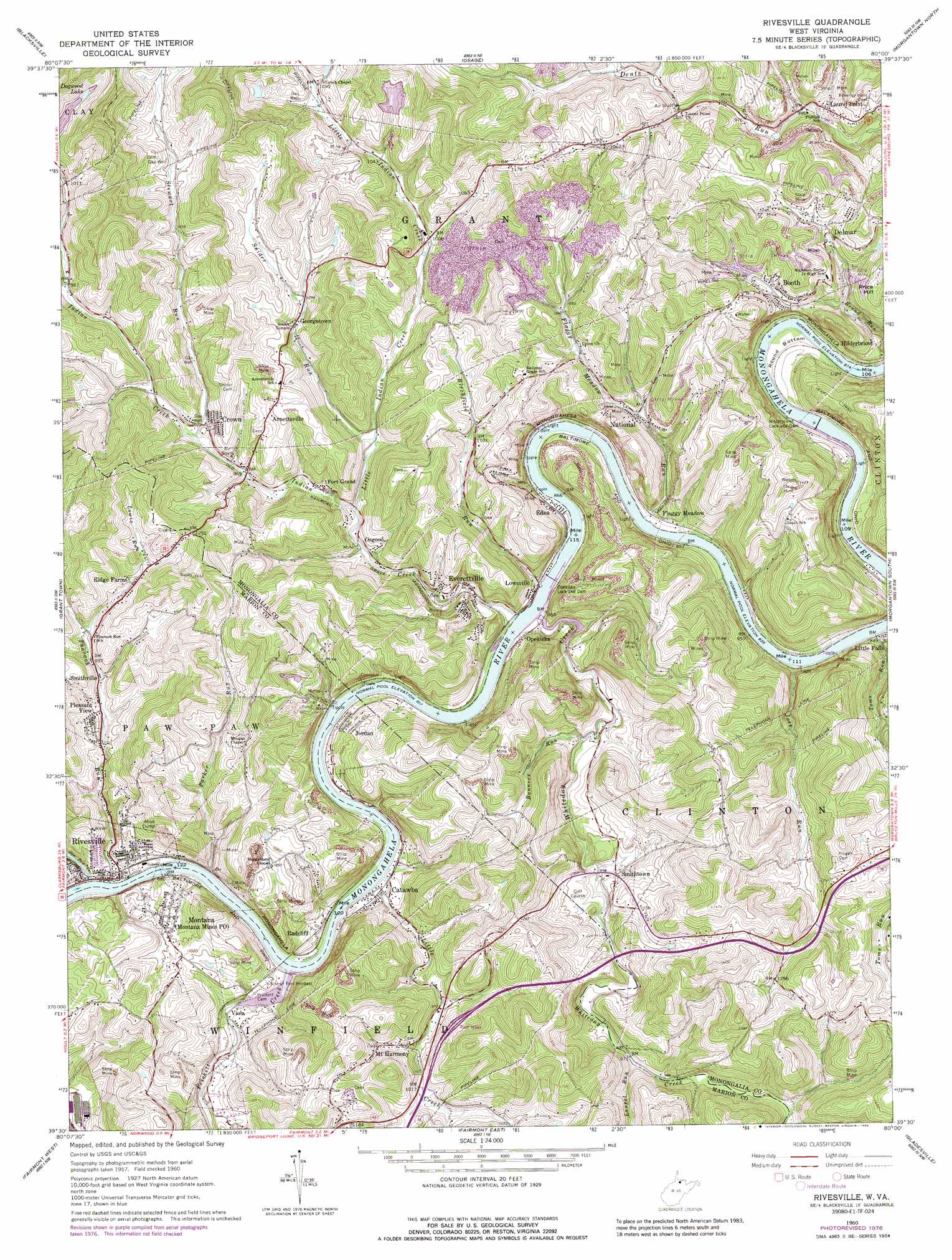
USGS Topo Quad 39080e1 - 1:24,000 scale
| Topo Map Name: | Rivesville |
| USGS Topo Quad ID: | 39080e1 |
| Print Size: | ca. 21 1/4" wide x 27" high |
| Southeast Coordinates: | 39.5° N latitude / 80° W longitude |
| Map Center Coordinates: | 39.5625° N latitude / 80.0625° W longitude |
| U.S. State: | WV |
| Filename: | o39080e1.jpg |
| Download Map JPG Image: | Rivesville topo map 1:24,000 scale |
| Map Type: | Topographic |
| Topo Series: | 7.5´ |
| Map Scale: | 1:24,000 |
| Source of Map Images: | United States Geological Survey (USGS) |
| Alternate Map Versions: |
Rivesville WV 1960, updated 1962 Download PDF Buy paper map Rivesville WV 1960, updated 1973 Download PDF Buy paper map Rivesville WV 1960, updated 1978 Download PDF Buy paper map Rivesville WV 1960, updated 1989 Download PDF Buy paper map Rivesville WV 1976, updated 1979 Download PDF Buy paper map Rivesville WV 1997, updated 2002 Download PDF Buy paper map Rivesville WV 2011 Download PDF Buy paper map Rivesville WV 2014 Download PDF Buy paper map Rivesville WV 2016 Download PDF Buy paper map |
1:24,000 Topo Quads surrounding Rivesville
Holbrook |
Oak Forest |
Garards Fort |
Masontown |
Smithfield |
Wadestown |
Blacksville |
Osage |
Morgantown North |
Lake Lynn |
Mannington |
Grant Town |
Rivesville |
Morgantown South |
Masontown |
Shinnston |
Fairmont West |
Fairmont East |
Gladesville |
Newburg |
Clarksburg |
Rosemont |
Grafton |
Thornton |
Fellowsville |
> Back to 39080e1 at 1:100,000 scale
> Back to 39080a1 at 1:250,000 scale
> Back to U.S. Topo Maps home
Rivesville topo map: Gazetteer
Rivesville: Dams
Everettville Refuse Embankment Dam elevation 351m 1151′Hildebrand Lock and Dam elevation 249m 816′
Hilderbrand Lock and Dam elevation 249m 816′
Jordan 93 Refuse Area Dam elevation 261m 856′
Lock Number 13 (historical) elevation 255m 836′
Lough Lake Dam elevation 412m 1351′
Lynch Lake Dam elevation 353m 1158′
Opekiska Lock and Dam elevation 272m 892′
Rivesville: Parks
Pricketts Fort State Park elevation 277m 908′Rivesville: Populated Places
Arnettsville elevation 368m 1207′Booth elevation 311m 1020′
Catawba elevation 267m 875′
Crown elevation 299m 980′
Delmar elevation 335m 1099′
Edna elevation 277m 908′
Everettville elevation 273m 895′
Flaggy Meadow elevation 266m 872′
Fort Grand elevation 299m 980′
Georgetown elevation 330m 1082′
Jordan elevation 278m 912′
Laurel Point elevation 301m 987′
Lowsville elevation 261m 856′
Montana elevation 309m 1013′
Mount Harmony elevation 327m 1072′
National elevation 294m 964′
Opekiska elevation 269m 882′
Osgood elevation 284m 931′
Pleasant View elevation 312m 1023′
Radcliff elevation 276m 905′
Richwood (historical) elevation 262m 859′
Ridge Farms elevation 341m 1118′
Rivesville elevation 264m 866′
Smithtown elevation 301m 987′
Smithville elevation 297m 974′
Viola elevation 263m 862′
Rivesville: Post Offices
Booth Post Office elevation 318m 1043′Montana Mines Post Office elevation 303m 994′
Rivesville: Reservoirs
Arwright Mine and Pond elevation 392m 1286′Consol Number 93 Impoundment elevation 261m 856′
Dogwood Lake elevation 331m 1085′
Hildebrand Pool elevation 249m 816′
Loar Acid Mine Drainage Treatment Lake elevation 361m 1184′
Lynch Lake elevation 353m 1158′
Opekiska Pool elevation 272m 892′
Rivesville: Springs
Alfred Howard Spring elevation 314m 1030′Arnett Spring elevation 323m 1059′
Baker Spring elevation 337m 1105′
Brooks Clayton Spring elevation 362m 1187′
Hershel Jackson Spring elevation 310m 1017′
Masgrove Spring elevation 289m 948′
McOlvin and Riddle Spring elevation 378m 1240′
Montana Mines Spring elevation 297m 974′
Morris Haller Spring elevation 324m 1062′
Robert Arnett Spring elevation 317m 1040′
Russel Hawkins Spring elevation 300m 984′
Rivesville: Streams
Birchfield Run elevation 261m 856′Bunners Run elevation 273m 895′
Craig Run elevation 302m 990′
Flaggy Meadow Run elevation 255m 836′
Indian Creek elevation 261m 856′
Joes Run elevation 255m 836′
Laurel Run elevation 297m 974′
Lewis Run elevation 304m 997′
Little Creek elevation 262m 859′
Little Indian Creek elevation 283m 928′
Parker Run elevation 263m 862′
Paw Paw Creek elevation 262m 859′
Pharaoh Run elevation 262m 859′
Prickett Creek elevation 262m 859′
Snider Run elevation 289m 948′
Stewart Run elevation 292m 958′
Toms Run elevation 256m 839′
Whiteday Creek elevation 261m 856′
Rivesville: Summits
Price Hill elevation 383m 1256′Rivesville digital topo map on disk
Buy this Rivesville topo map showing relief, roads, GPS coordinates and other geographical features, as a high-resolution digital map file on DVD:
 map DVD")