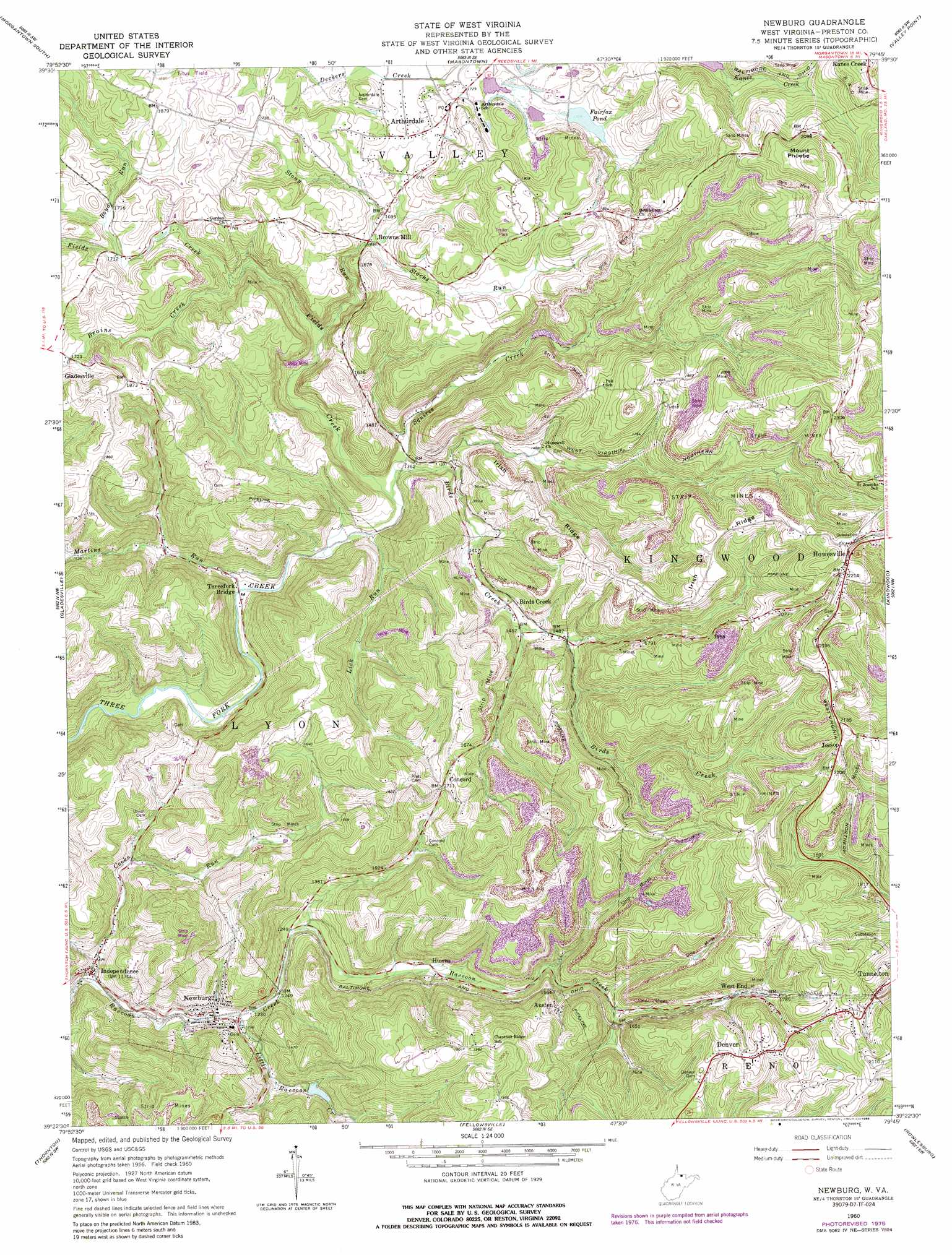
Newburg Topo Map West Virginia
To zoom in, hover over the map of Newburg
USGS Topo Quad 39079d7 - 1:24,000 scale
| Topo Map Name: | Newburg |
| USGS Topo Quad ID: | 39079d7 |
| Print Size: | ca. 21 1/4" wide x 27" high |
| Southeast Coordinates: | 39.375° N latitude / 79.75° W longitude |
| Map Center Coordinates: | 39.4375° N latitude / 79.8125° W longitude |
| U.S. State: | WV |
| Filename: | o39079d7.jpg |
| Download Map JPG Image: | Newburg topo map 1:24,000 scale |
| Map Type: | Topographic |
| Topo Series: | 7.5´ |
| Map Scale: | 1:24,000 |
| Source of Map Images: | United States Geological Survey (USGS) |
| Alternate Map Versions: |
Newburg WV 1960, updated 1962 Download PDF Buy paper map Newburg WV 1960, updated 1968 Download PDF Buy paper map Newburg WV 1960, updated 1977 Download PDF Buy paper map Newburg WV 1960, updated 1988 Download PDF Buy paper map Newburg WV 1997, updated 2001 Download PDF Buy paper map Newburg WV 2011 Download PDF Buy paper map Newburg WV 2014 Download PDF Buy paper map Newburg WV 2016 Download PDF Buy paper map |
1:24,000 Topo Quads surrounding Newburg
Osage |
Morgantown North |
Lake Lynn |
Bruceton Mills |
Brandonville |
Rivesville |
Morgantown South |
Masontown |
Valley Point |
Cuzzart |
Fairmont East |
Gladesville |
Newburg |
Kingwood |
Terra Alta |
Grafton |
Thornton |
Fellowsville |
Rowlesburg |
Aurora |
Philippi |
Nestorville |
Colebank |
Saint George |
Lead Mine |
> Back to 39079a1 at 1:100,000 scale
> Back to 39078a1 at 1:250,000 scale
> Back to U.S. Topo Maps home
Newburg topo map: Gazetteer
Newburg: Airports
Titus Field elevation 567m 1860′Newburg: Dams
B O Dam on Little Raccoon Creek elevation 420m 1377′Fairfax Pond Dam elevation 531m 1742′
Upper Deckers Creek Structure Number Six Dam elevation 520m 1706′
Newburg: Parks
Arthurdale Historic District elevation 541m 1774′Newburg: Populated Places
Arthurdale elevation 541m 1774′Austen elevation 494m 1620′
Birds Creek elevation 439m 1440′
Browns Mill elevation 505m 1656′
Chestnut Ridge elevation 597m 1958′
Concord elevation 520m 1706′
Denver elevation 617m 2024′
Hiorra elevation 412m 1351′
Howesville elevation 676m 2217′
Independence elevation 360m 1181′
Jessop elevation 659m 2162′
Mountain View elevation 676m 2217′
Newburg elevation 371m 1217′
Oriole (historical) elevation 458m 1502′
Threefork Bridge elevation 392m 1286′
Towson (historical) elevation 625m 2050′
West End elevation 550m 1804′
Newburg: Post Offices
Arthurdale Post Office elevation 539m 1768′Independence Post Office (historical) elevation 373m 1223′
Newburg: Reservoirs
Fairfax Pond elevation 523m 1715′Newburg: Ridges
Irish Ridge elevation 579m 1899′Newburg: Streams
Birds Creek elevation 398m 1305′Boyd Run elevation 518m 1699′
Brains Creek elevation 483m 1584′
Cooks Run elevation 351m 1151′
Fields Creek elevation 398m 1305′
Lick Run elevation 392m 1286′
Little Raccoon Creek elevation 369m 1210′
Martins Run elevation 386m 1266′
Squires Creek elevation 400m 1312′
Stacks Run elevation 501m 1643′
Stony Run elevation 434m 1423′
Newburg: Summits
Mount Phoebe elevation 715m 2345′Newburg: Tunnels
Kingwood Tunnel elevation 609m 1998′Newburg digital topo map on disk
Buy this Newburg topo map showing relief, roads, GPS coordinates and other geographical features, as a high-resolution digital map file on DVD:
 map DVD")