Soldier Summit Topo Map Utah
To zoom in, hover over the map of Soldier Summit
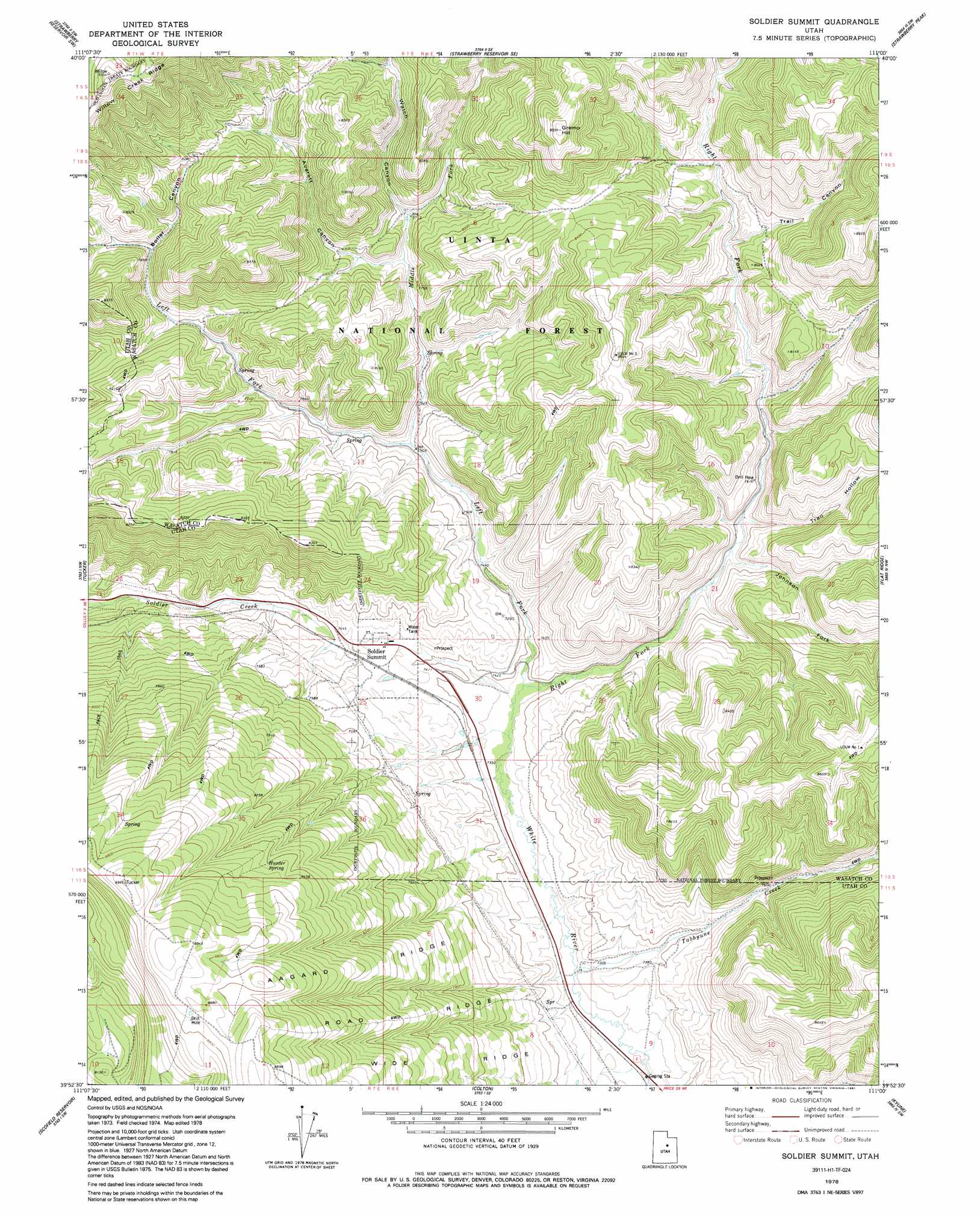
USGS Topo Quad 39111h1 - 1:24,000 scale
| Topo Map Name: | Soldier Summit |
| USGS Topo Quad ID: | 39111h1 |
| Print Size: | ca. 21 1/4" wide x 27" high |
| Southeast Coordinates: | 39.875° N latitude / 111° W longitude |
| Map Center Coordinates: | 39.9375° N latitude / 111.0625° W longitude |
| U.S. State: | UT |
| Filename: | o39111h1.jpg |
| Download Map JPG Image: | Soldier Summit topo map 1:24,000 scale |
| Map Type: | Topographic |
| Topo Series: | 7.5´ |
| Map Scale: | 1:24,000 |
| Source of Map Images: | United States Geological Survey (USGS) |
| Alternate Map Versions: |
Soldier Summit UT 1978, updated 1979 Download PDF Buy paper map Soldier Summit UT 1978, updated 1991 Download PDF Buy paper map Soldier Summit UT 1998, updated 2002 Download PDF Buy paper map Soldier Summit UT 2011 Download PDF Buy paper map Soldier Summit UT 2014 Download PDF Buy paper map |
| FStopo: | US Forest Service topo Soldier Summit is available: Download FStopo PDF Download FStopo TIF |
1:24,000 Topo Quads surrounding Soldier Summit
Two Tom Hill |
Strawberry Reservoir Nw |
Strawberry Reservoir Ne |
Deep Creek Canyon |
Fruitland |
Rays Valley |
Strawberry Reservoir Sw |
Strawberry Reservoir Se |
Strawberry Peak |
Avintaquin Canyon |
Mill Fork |
Tucker |
Soldier Summit |
Flat Ridge |
Gray Head Peak |
C Canyon |
Scofield Reservoir |
Colton |
Kyune |
Matts Summit |
Fairview Lakes |
Scofield |
Jump Creek |
Standardville |
Helper |
> Back to 39111e1 at 1:100,000 scale
> Back to 39110a1 at 1:250,000 scale
> Back to U.S. Topo Maps home
Soldier Summit topo map: Gazetteer
Soldier Summit: Populated Places
Soldier Summit elevation 2277m 7470′Soldier Summit: Ridges
Aagard Ridge elevation 2543m 8343′Road Ridge elevation 2492m 8175′
Wide Ridge elevation 2425m 7956′
Soldier Summit: Springs
Hunter Spring elevation 2570m 8431′Soldier Summit: Streams
Johnson Fork elevation 2286m 7500′Left Fork White River elevation 2244m 7362′
Middle Fork White River elevation 2291m 7516′
Right Fork White River elevation 2244m 7362′
Tabbyune Creek elevation 2216m 7270′
Soldier Summit: Summits
Gremo Hill elevation 2762m 9061′Soldier Summit: Valleys
Averett Canyon elevation 2335m 7660′Boiler Canyon elevation 2417m 7929′
Tabbyune Canyon elevation 2215m 7267′
Trail Canyon elevation 2367m 7765′
Trail Hollow elevation 2295m 7529′
Watch Canyon elevation 2356m 7729′
Soldier Summit digital topo map on disk
Buy this Soldier Summit topo map showing relief, roads, GPS coordinates and other geographical features, as a high-resolution digital map file on DVD: