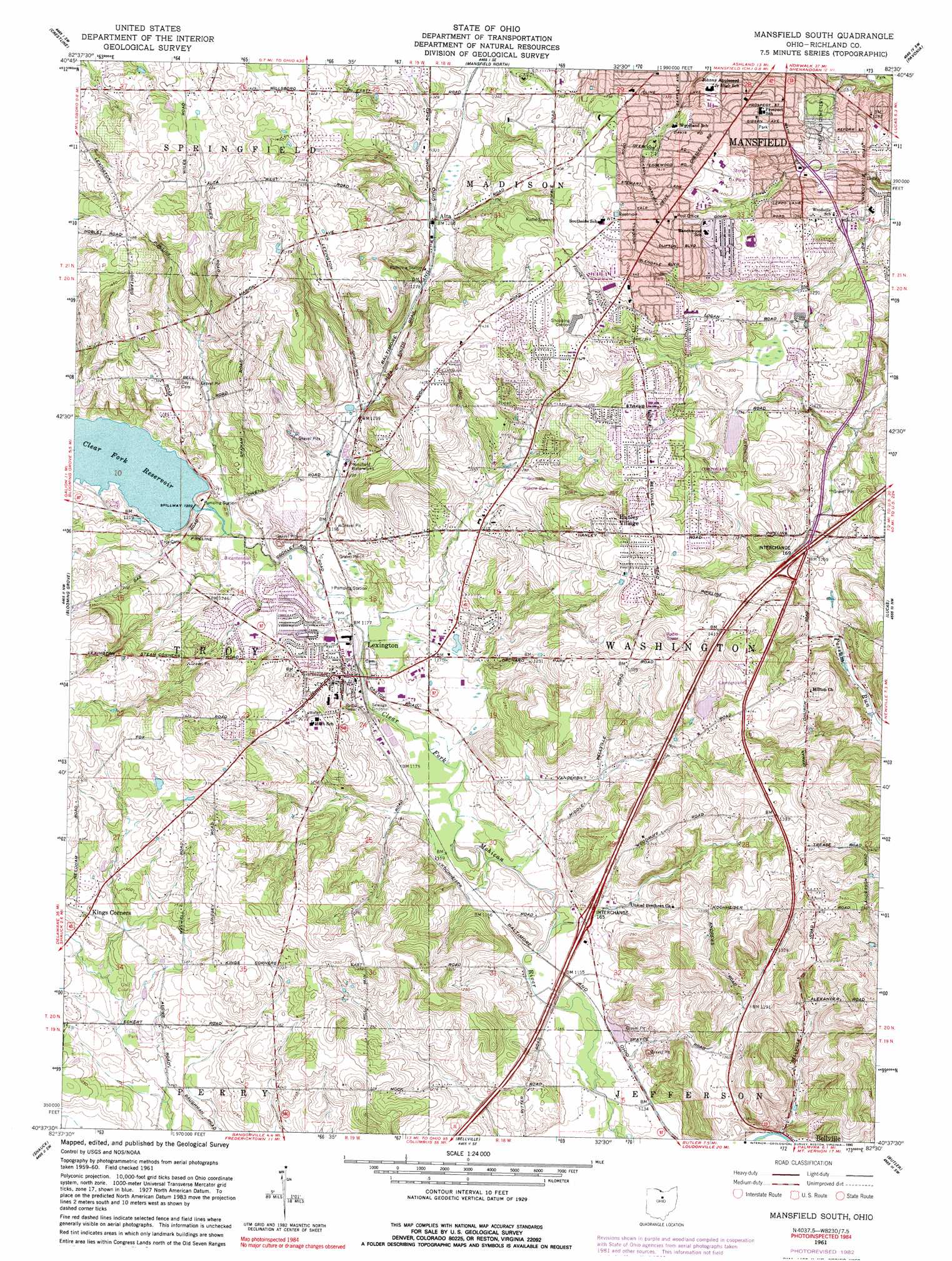
Mansfield South Topo Map Ohio
To zoom in, hover over the map of Mansfield South
USGS Topo Quad 40082f5 - 1:24,000 scale
| Topo Map Name: | Mansfield South |
| USGS Topo Quad ID: | 40082f5 |
| Print Size: | ca. 21 1/4" wide x 27" high |
| Southeast Coordinates: | 40.625° N latitude / 82.5° W longitude |
| Map Center Coordinates: | 40.6875° N latitude / 82.5625° W longitude |
| U.S. State: | OH |
| Filename: | o40082f5.jpg |
| Download Map JPG Image: | Mansfield South topo map 1:24,000 scale |
| Map Type: | Topographic |
| Topo Series: | 7.5´ |
| Map Scale: | 1:24,000 |
| Source of Map Images: | United States Geological Survey (USGS) |
| Alternate Map Versions: |
Mansfield South OH 1961, updated 1962 Download PDF Buy paper map Mansfield South OH 1961, updated 1972 Download PDF Buy paper map Mansfield South OH 1961, updated 1975 Download PDF Buy paper map Mansfield South OH 1961, updated 1983 Download PDF Buy paper map Mansfield South OH 1961, updated 1990 Download PDF Buy paper map Mansfield South OH 2010 Download PDF Buy paper map Mansfield South OH 2013 Download PDF Buy paper map Mansfield South OH 2016 Download PDF Buy paper map |
1:24,000 Topo Quads surrounding Mansfield South
New Washington |
Shelby |
Shiloh |
Olivesburg |
Ashland North |
North Robinson |
Crestline |
Mansfield North |
Pavonia |
Ashland South |
Galion |
Blooming Grove |
Mansfield South |
Lucas |
Perrysville |
Mount Gilead |
Shauck |
Bellville |
Butler |
Jelloway |
Marengo |
Chesterville |
Fredericktown |
Mount Vernon |
Danville |
> Back to 40082e1 at 1:100,000 scale
> Back to 40082a1 at 1:250,000 scale
> Back to U.S. Topo Maps home
Mansfield South topo map: Gazetteer
Mansfield South: Crossings
Interchange 165 elevation 360m 1181′Interchange 169 elevation 384m 1259′
Mansfield South: Dams
Clearfork Reservoir Dam elevation 368m 1207′Fallerius Pond Dam elevation 414m 1358′
Lake Maria Dam elevation 402m 1318′
Mansfield South: Parks
Bicentennial Park elevation 358m 1174′Dickson Park elevation 417m 1368′
Gorman Nature Park elevation 392m 1286′
John Todd Park elevation 376m 1233′
Lexington Park elevation 354m 1161′
Prospect Park elevation 419m 1374′
Sterkel Park elevation 414m 1358′
Sunset Park elevation 419m 1374′
Mansfield South: Populated Places
Alta elevation 392m 1286′Hanley Village elevation 436m 1430′
Ken-mar Mobile Home Park elevation 385m 1263′
Kings Corners elevation 394m 1292′
Lexington elevation 371m 1217′
South Boulevards elevation 442m 1450′
Mansfield South: Post Offices
Alta Post Office (historical) elevation 392m 1286′Lexington Post Office (historical) elevation 365m 1197′
Mansfield South: Reservoirs
Clear Fork Reservoir elevation 368m 1207′Fallerius Pond elevation 414m 1358′
Lake Maria elevation 402m 1318′
Mansfield South digital topo map on disk
Buy this Mansfield South topo map showing relief, roads, GPS coordinates and other geographical features, as a high-resolution digital map file on DVD:
 map DVD")