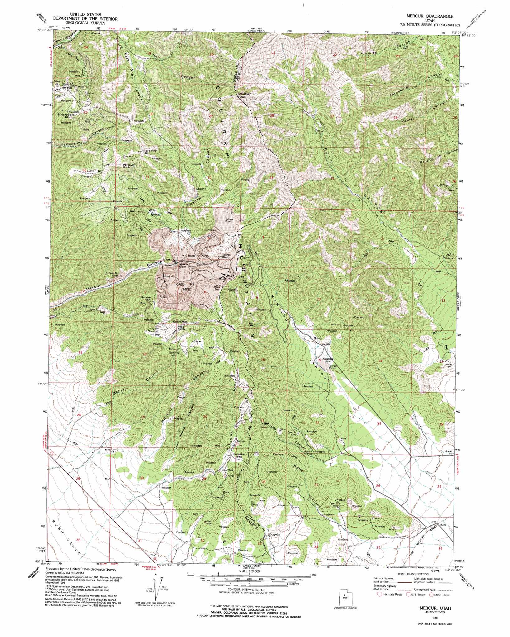
Mercur Topo Map Utah
To zoom in, hover over the map of Mercur
USGS Topo Quad 40112c2 - 1:24,000 scale
| Topo Map Name: | Mercur |
| USGS Topo Quad ID: | 40112c2 |
| Print Size: | ca. 21 1/4" wide x 27" high |
| Southeast Coordinates: | 40.25° N latitude / 112.125° W longitude |
| Map Center Coordinates: | 40.3125° N latitude / 112.1875° W longitude |
| U.S. State: | UT |
| Filename: | o40112c2.jpg |
| Download Map JPG Image: | Mercur topo map 1:24,000 scale |
| Map Type: | Topographic |
| Topo Series: | 7.5´ |
| Map Scale: | 1:24,000 |
| Source of Map Images: | United States Geological Survey (USGS) |
| Alternate Map Versions: |
Mercur UT 1968, updated 1970 Download PDF Buy paper map Mercur UT 1968, updated 1971 Download PDF Buy paper map Mercur UT 1993, updated 1993 Download PDF Buy paper map Mercur UT 1997, updated 2002 Download PDF Buy paper map Mercur UT 2011 Download PDF Buy paper map Mercur UT 2014 Download PDF Buy paper map |
1:24,000 Topo Quads surrounding Mercur
Grantsville |
Tooele |
Bingham Canyon |
Lark |
Midvale |
South Mountain |
Stockton |
Lowe Peak |
Tickville Spring |
Jordan Narrows |
Saint John |
Ophir |
Mercur |
Cedar Fort |
Saratoga Springs |
Faust |
Vernon Ne |
Fivemile Pass |
Goshen Pass |
Soldiers Pass |
Vernon |
Lofgreen |
Boulter Peak |
Allens Ranch |
Goshen Valley North |
> Back to 40112a1 at 1:100,000 scale
> Back to 40112a1 at 1:250,000 scale
> Back to U.S. Topo Maps home
Mercur topo map: Gazetteer
Mercur: Mines
Chloride Point Mine elevation 2500m 8202′Clay Mine elevation 1709m 5606′
Geyser-Marion Mine elevation 2057m 6748′
Golden Gate Mine elevation 2060m 6758′
Sacramento Mine elevation 2209m 7247′
Violet Ray Mine elevation 2292m 7519′
Mercur: Populated Places
Mercur (historical) elevation 2030m 6660′Mercur: Summits
Eagle Hill elevation 2406m 7893′Flat Top Mountain elevation 3235m 10613′
Lewiston Peak elevation 3161m 10370′
Lion Hill elevation 2586m 8484′
Porphyry Hill elevation 2645m 8677′
Porphyry Knob elevation 2599m 8526′
Rover Hill elevation 2570m 8431′
Silveropolis Hill elevation 2625m 8612′
Sunrise Hill elevation 2319m 7608′
Mercur: Valleys
Alma Young Canyon elevation 1709m 5606′Clay Canyon elevation 1663m 5456′
Hall Canyon elevation 2158m 7080′
Long Trail Gulch elevation 1990m 6528′
Manning Canyon elevation 1659m 5442′
McFait Canyon elevation 1771m 5810′
Meadow Canyon elevation 2040m 6692′
Mitchell Canyon elevation 1766m 5793′
Pole Canyon elevation 1708m 5603′
Sacramento Gulch elevation 2008m 6587′
Sunshine Canyon elevation 1745m 5725′
Wells Canyon elevation 1621m 5318′
Mercur digital topo map on disk
Buy this Mercur topo map showing relief, roads, GPS coordinates and other geographical features, as a high-resolution digital map file on DVD: