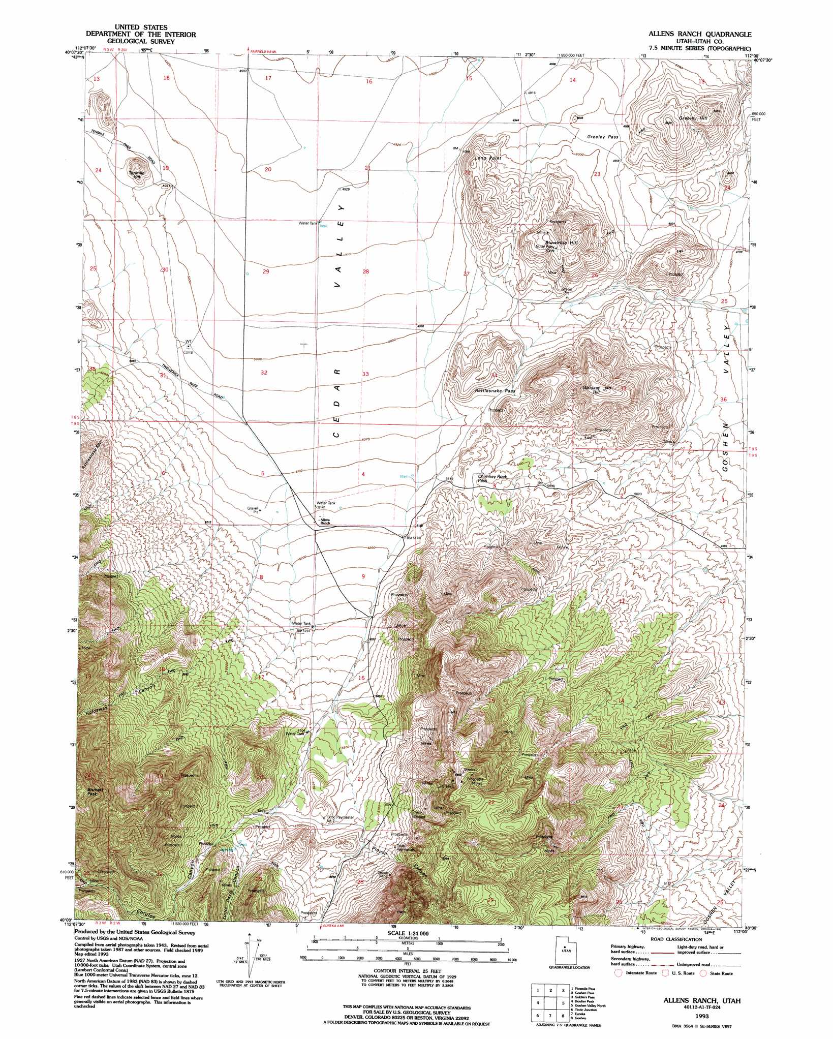
Allens Ranch Topo Map Utah
To zoom in, hover over the map of Allens Ranch
USGS Topo Quad 40112a1 - 1:24,000 scale
| Topo Map Name: | Allens Ranch |
| USGS Topo Quad ID: | 40112a1 |
| Print Size: | ca. 21 1/4" wide x 27" high |
| Southeast Coordinates: | 40° N latitude / 112° W longitude |
| Map Center Coordinates: | 40.0625° N latitude / 112.0625° W longitude |
| U.S. State: | UT |
| Filename: | o40112a1.jpg |
| Download Map JPG Image: | Allens Ranch topo map 1:24,000 scale |
| Map Type: | Topographic |
| Topo Series: | 7.5´ |
| Map Scale: | 1:24,000 |
| Source of Map Images: | United States Geological Survey (USGS) |
| Alternate Map Versions: |
Allens Ranch UT 1947, updated 1958 Download PDF Buy paper map Allens Ranch UT 1947, updated 1970 Download PDF Buy paper map Allens Ranch UT 1947, updated 1981 Download PDF Buy paper map Allens Ranch UT 1949 Download PDF Buy paper map Allens Ranch UT 1993, updated 1993 Download PDF Buy paper map Allens Ranch UT 2011 Download PDF Buy paper map Allens Ranch UT 2014 Download PDF Buy paper map |
1:24,000 Topo Quads surrounding Allens Ranch
Ophir |
Mercur |
Cedar Fort |
Saratoga Springs |
Pelican Point |
Vernon Ne |
Fivemile Pass |
Goshen Pass |
Soldiers Pass |
Lincoln Point |
Lofgreen |
Boulter Peak |
Allens Ranch |
Goshen Valley North |
West Mountain |
Sabie Mountain |
Tintic Junction |
Eureka |
Goshen |
Santaquin |
Maple Peak |
Mcintyre |
Tintic Mountain |
Slate Jack Canyon |
Mona |
> Back to 40112a1 at 1:100,000 scale
> Back to 40112a1 at 1:250,000 scale
> Back to U.S. Topo Maps home
Allens Ranch topo map: Gazetteer
Allens Ranch: Capes
Long Point elevation 1587m 5206′Allens Ranch: Gaps
Chimney Rock Pass elevation 1582m 5190′Greeley Pass elevation 1522m 4993′
Rattlesnake Pass elevation 1574m 5164′
Allens Ranch: Mines
Lehi Tintic elevation 2001m 6564′Selma Mine elevation 1845m 6053′
Tintic Empire elevation 1796m 5892′
Tintic Paymaster elevation 1785m 5856′
Tintic Paymaster Number 2 elevation 1726m 5662′
Allens Ranch: Summits
Blowhole Hill elevation 1646m 5400′Greeley Hill elevation 1581m 5187′
Tenmile Hill elevation 1592m 5223′
Wanlass Hill elevation 1731m 5679′
Allens Ranch: Valleys
Chiulos Canyon elevation 1657m 5436′Holdaway Canyon elevation 1702m 5583′
Pinyon Canyon elevation 1741m 5711′
Tintic Davis Canyon elevation 1724m 5656′
Allens Ranch digital topo map on disk
Buy this Allens Ranch topo map showing relief, roads, GPS coordinates and other geographical features, as a high-resolution digital map file on DVD: