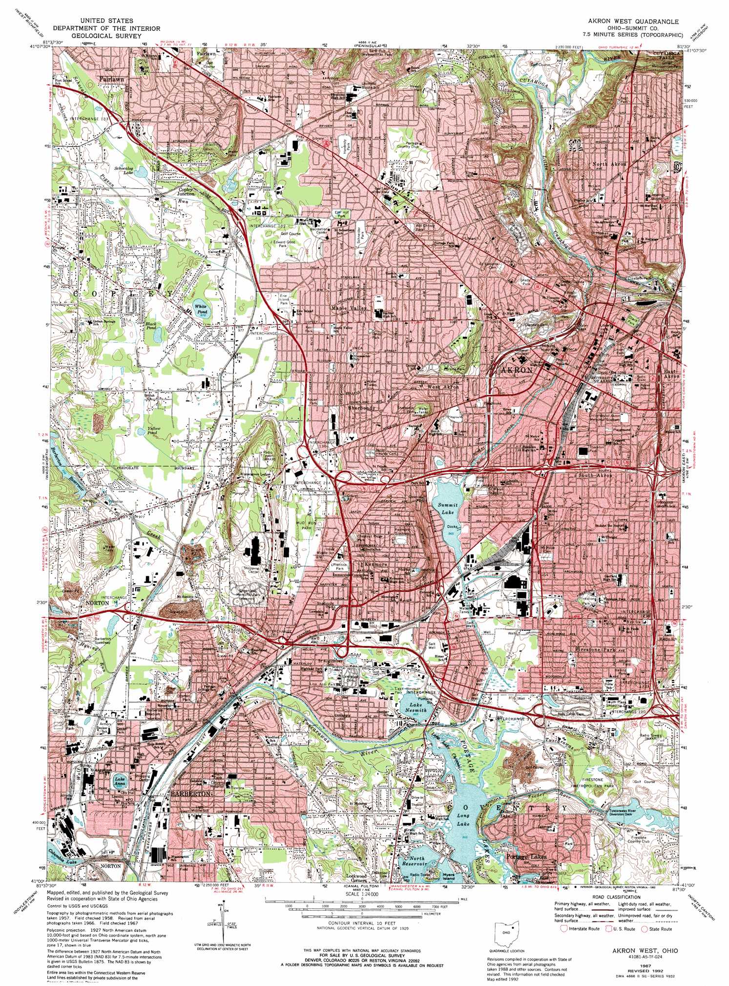
Akron West Topo Map Ohio
To zoom in, hover over the map of Akron West
USGS Topo Quad 41081a5 - 1:24,000 scale
| Topo Map Name: | Akron West |
| USGS Topo Quad ID: | 41081a5 |
| Print Size: | ca. 21 1/4" wide x 27" high |
| Southeast Coordinates: | 41° N latitude / 81.5° W longitude |
| Map Center Coordinates: | 41.0625° N latitude / 81.5625° W longitude |
| U.S. State: | OH |
| Filename: | o41081a5.jpg |
| Download Map JPG Image: | Akron West topo map 1:24,000 scale |
| Map Type: | Topographic |
| Topo Series: | 7.5´ |
| Map Scale: | 1:24,000 |
| Source of Map Images: | United States Geological Survey (USGS) |
| Alternate Map Versions: |
Akron West OH 1958, updated 1959 Download PDF Buy paper map Akron West OH 1967, updated 1970 Download PDF Buy paper map Akron West OH 1967, updated 1978 Download PDF Buy paper map Akron West OH 1967, updated 1980 Download PDF Buy paper map Akron West OH 1967, updated 1992 Download PDF Buy paper map Akron West OH 1994, updated 1997 Download PDF Buy paper map Akron West OH 2010 Download PDF Buy paper map Akron West OH 2013 Download PDF Buy paper map Akron West OH 2016 Download PDF Buy paper map |
1:24,000 Topo Quads surrounding Akron West
Berea |
Broadview Heights |
Northfield |
Twinsburg |
Aurora |
Medina |
West Richfield |
Peninsula |
Hudson |
Kent |
Seville |
Wadsworth |
Akron West |
Akron East |
Suffield |
Rittman |
Doylestown |
Canal Fulton |
North Canton |
Hartville |
Orrville |
Dalton |
Massillon |
Canton West |
Canton East |
> Back to 41081a1 at 1:100,000 scale
> Back to 41080a1 at 1:250,000 scale
> Back to U.S. Topo Maps home
Akron West topo map: Gazetteer
Akron West: Airports
Akron City Hospital Heliport elevation 318m 1043′Akron General Medical Center Heliport elevation 294m 964′
Cascade Holiday Inn Heliport elevation 287m 941′
Childrens Hospital Heliport elevation 294m 964′
Saint Thomas Hospital Heliport elevation 292m 958′
Akron West: Benches
Wintergreen Ledges elevation 329m 1079′Akron West: Crossings
Interchange 120 elevation 308m 1010′Interchange 123A elevation 313m 1026′
Interchange 123B elevation 337m 1105′
Interchange 130 elevation 301m 987′
Interchange 131 elevation 300m 984′
Interchange 132 elevation 299m 980′
Interchange 133 elevation 303m 994′
Interchange 14 elevation 295m 967′
Interchange 16 elevation 295m 967′
Interchange 2 elevation 303m 994′
Interchange 21A elevation 305m 1000′
Interchange 3 elevation 300m 984′
Akron West: Dams
Columbia Lake Dam elevation 299m 980′East Reservoir Dam elevation 302m 990′
Long Lake Dam elevation 295m 967′
North Reservoir Dam elevation 293m 961′
Tuscarawas River Diversion Dam elevation 302m 990′
Wolf Creek Dam elevation 305m 1000′
Akron West: Islands
Myers Island elevation 306m 1003′Akron West: Lakes
Columbia Lake elevation 295m 967′Lake Anna elevation 295m 967′
Lake Nesmith elevation 293m 961′
Long Lake Channel elevation 295m 967′
Mannings Pond elevation 295m 967′
Portage Lakes elevation 322m 1056′
Akron West: Parks
Aquae Park elevation 300m 984′Avon Park elevation 301m 987′
Barberton Stadium elevation 296m 971′
Canal Park elevation 289m 948′
Canal Park elevation 296m 971′
Cascade Valley Park elevation 237m 777′
Chestnut Ridge Park elevation 310m 1017′
Childrens Zoo elevation 332m 1089′
Clearview Park elevation 306m 1003′
Crisman Park elevation 315m 1033′
Decker Park elevation 295m 967′
Dover Park elevation 311m 1020′
Elizabeth Park elevation 261m 856′
Elm Hill Park elevation 301m 987′
Erie Island Park elevation 298m 977′
Firestone Metropolitan Park elevation 295m 967′
Firestone Park Stadium elevation 300m 984′
Fort Island Park elevation 301m 987′
Frank Boulevard Park elevation 317m 1040′
Glendale Park elevation 287m 941′
Gorge Metropolitan Park elevation 251m 823′
Grace Park elevation 314m 1030′
Griffith Park elevation 301m 987′
Hall Park Allotment Historic District elevation 304m 997′
Hardesty Park elevation 302m 990′
Heintz Park elevation 323m 1059′
Kenmore Park elevation 315m 1033′
Kenmore Stadium elevation 332m 1089′
Kerr Park elevation 301m 987′
Lake Nesmith Park elevation 296m 971′
Lee R Jackson Field elevation 317m 1040′
Lisa Ann Park elevation 302m 990′
Lookout Park elevation 301m 987′
Mud Run Park elevation 293m 961′
Newton Park elevation 299m 980′
Northwest Park elevation 304m 997′
Patterson Park elevation 293m 961′
Perkins Park elevation 323m 1059′
Prentiss Park elevation 298m 977′
Saint Marys Stadium elevation 309m 1013′
Schneider Park elevation 303m 994′
Shady Park elevation 295m 967′
Shadyside Park elevation 299m 980′
Sherbondy Park elevation 347m 1138′
Summit Lake Park elevation 295m 967′
Thornton Park elevation 315m 1033′
Tuscarawas Avenue-Alexander Square Commerical Historic District elevation 295m 967′
Tuscora Park elevation 319m 1046′
Union Park elevation 314m 1030′
University of Akron Memorial Stadium elevation 316m 1036′
Waters Park elevation 302m 990′
Westlake Manor Park elevation 302m 990′
Will Christy Park elevation 321m 1053′
Akron West: Populated Places
Akron elevation 291m 954′Barberton elevation 297m 974′
Barberton Trailer Park (historical) elevation 295m 967′
Cascade (historical) elevation 288m 944′
Copley Junction elevation 302m 990′
Firestone Park elevation 332m 1089′
Halo elevation 319m 1046′
Kenmore elevation 313m 1026′
Lakeside Mobile Park elevation 297m 974′
Lawndale elevation 306m 1003′
M And C Mobile Village elevation 307m 1007′
Maple Valley elevation 302m 990′
Nemes Trailer Park elevation 295m 967′
New Portage elevation 320m 1049′
North Akron elevation 304m 997′
Portage Lakes elevation 321m 1053′
Shamrock Trailer Park elevation 292m 958′
South Akron elevation 316m 1036′
Summit Beach Park elevation 296m 971′
Swartz Corners elevation 296m 971′
West Akron elevation 305m 1000′
Akron West: Post Offices
Akron Post Office elevation 286m 938′Barberton Post Office elevation 295m 967′
Barberton Post Office elevation 297m 974′
Barberton Post Office (historical) elevation 297m 974′
Lawndale Post Office (historical) elevation 306m 1003′
Akron West: Reservoirs
Barberton Reservoir elevation 299m 980′Black Pond elevation 298m 977′
Dollar Lake elevation 295m 967′
East Reservoir elevation 296m 971′
Firestone Reservoir elevation 305m 1000′
Long Lake elevation 296m 971′
North Reservoir elevation 298m 977′
Schocalog Lake elevation 301m 987′
Summit Lake elevation 295m 967′
White Pond elevation 298m 977′
Yellow Pond elevation 295m 967′
Akron West: Streams
Babb Run elevation 237m 777′Feeder Race River elevation 297m 974′
Little Cuyahoga River elevation 231m 757′
Mud Run elevation 292m 958′
Pigeon Creek elevation 293m 961′
Schocalog Run elevation 296m 971′
Van Hyning Run elevation 292m 958′
Wolf Creek elevation 289m 948′
Akron West: Summits
Sherbondy Hill elevation 348m 1141′Akron West: Swamps
Copley Swamp (historical) elevation 295m 967′Perkins Swamp (historical) elevation 302m 990′
Akron West digital topo map on disk
Buy this Akron West topo map showing relief, roads, GPS coordinates and other geographical features, as a high-resolution digital map file on DVD:
 map DVD")