Culver Topo Map Indiana
To zoom in, hover over the map of Culver
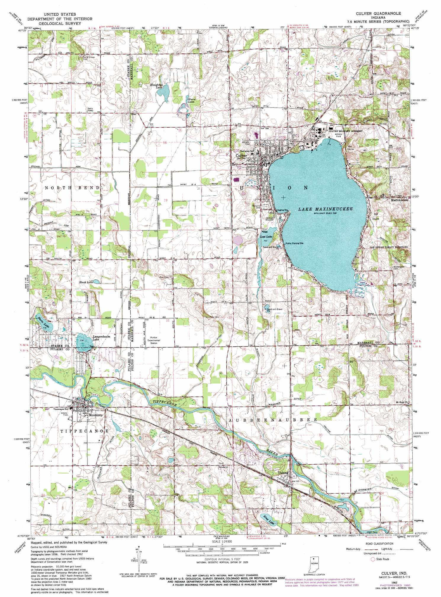
USGS Topo Quad 41086b4 - 1:24,000 scale
| Topo Map Name: | Culver |
| USGS Topo Quad ID: | 41086b4 |
| Print Size: | ca. 21 1/4" wide x 27" high |
| Southeast Coordinates: | 41.125° N latitude / 86.375° W longitude |
| Map Center Coordinates: | 41.1875° N latitude / 86.4375° W longitude |
| U.S. State: | IN |
| Filename: | o41086b4.jpg |
| Download Map JPG Image: | Culver topo map 1:24,000 scale |
| Map Type: | Topographic |
| Topo Series: | 7.5´ |
| Map Scale: | 1:24,000 |
| Source of Map Images: | United States Geological Survey (USGS) |
| Alternate Map Versions: |
Culver IN 1962, updated 1964 Download PDF Buy paper map Culver IN 1962, updated 1976 Download PDF Buy paper map Culver IN 1962, updated 1980 Download PDF Buy paper map Culver IN 2010 Download PDF Buy paper map Culver IN 2013 Download PDF Buy paper map Culver IN 2016 Download PDF Buy paper map |
1:24,000 Topo Quads surrounding Culver
Kingsford Heights |
Hamlet |
Walkerton |
La Paz |
Bremen |
Knox West |
Knox East |
Donaldson |
Plymouth |
Inwood |
Denham |
Bass Lake |
Culver |
Rutland |
Argos |
Ripley |
Winamac |
Kewanna |
Pershing |
Rochester |
Buffalo |
Star City |
Grass Creek |
Fulton |
Macy |
> Back to 41086a1 at 1:100,000 scale
> Back to 41086a1 at 1:250,000 scale
> Back to U.S. Topo Maps home
Culver topo map: Gazetteer
Culver: Airports
Fleet Field elevation 248m 813′Jacks Field elevation 224m 734′
Culver: Canals
Chapman Ditch elevation 220m 721′Collins Ditch elevation 228m 748′
Curtiss Ditch elevation 226m 741′
Demont Arm elevation 222m 728′
Hawkins Ditch elevation 222m 728′
Lowry Ditch elevation 234m 767′
Slonaker Ditch elevation 222m 728′
Thompson Ditch elevation 223m 731′
Wagoner Ditch elevation 224m 734′
Williams Arm Ditch elevation 223m 731′
Wilson Ditch elevation 222m 728′
Zechiel Arm elevation 222m 728′
Culver: Lakes
Hartz Lake elevation 220m 721′Houghton Lake elevation 222m 728′
King Lake elevation 225m 738′
Langenbaum Lake elevation 219m 718′
Lost Lake elevation 223m 731′
Moore Lake elevation 222m 728′
Culver: Populated Places
Culver elevation 235m 770′Delong elevation 225m 738′
Maxinkuckee elevation 243m 797′
Monterey elevation 221m 725′
Culver: Reservoirs
Lake Maxinkuckee elevation 223m 731′Culver digital topo map on disk
Buy this Culver topo map showing relief, roads, GPS coordinates and other geographical features, as a high-resolution digital map file on DVD:
Northern Illinois, Northern Indiana & Southwestern Michigan
Buy digital topo maps: Northern Illinois, Northern Indiana & Southwestern Michigan