Mcgrew Topo Map Nebraska
To zoom in, hover over the map of Mcgrew
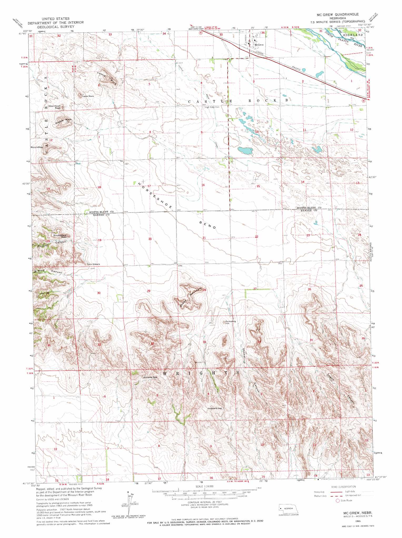
USGS Topo Quad 41103f4 - 1:24,000 scale
| Topo Map Name: | Mcgrew |
| USGS Topo Quad ID: | 41103f4 |
| Print Size: | ca. 21 1/4" wide x 27" high |
| Southeast Coordinates: | 41.625° N latitude / 103.375° W longitude |
| Map Center Coordinates: | 41.6875° N latitude / 103.4375° W longitude |
| U.S. State: | NE |
| Filename: | O41103F4.jpg |
| Download Map JPG Image: | Mcgrew topo map 1:24,000 scale |
| Map Type: | Topographic |
| Topo Series: | 7.5´ |
| Map Scale: | 1:24,000 |
| Source of Map Images: | United States Geological Survey (USGS) |
| Alternate Map Versions: |
McGrew NE 1965, updated 1967 Download PDF Buy paper map McGrew NE 2011 Download PDF Buy paper map McGrew NE 2014 Download PDF Buy paper map |
1:24,000 Topo Quads surrounding Mcgrew
Scottsbluff North |
Lake Alice |
Lake Minatare |
Bayard Ne |
Angora Nw |
Scottsbluff South |
Minatare |
Bayard Sw |
Bayard |
Angora |
Wildcat Mountain |
Wright Gap |
Mcgrew |
South Bayard |
Bridgeport Nw |
Harrisburg |
Indian Springs |
Hackberry Creek |
Redington |
Roundhouse Rock |
Bennett Reservoir Nw |
Lone Pine Butte |
Singleton Ranch |
Potter 2 Ne |
Horsehead Ranch |
> Back to 41103e1 at 1:100,000 scale
> Back to 41102a1 at 1:250,000 scale
> Back to U.S. Topo Maps home
Mcgrew topo map: Gazetteer
Mcgrew: Bends
Horseshoe Bend elevation 1186m 3891′Mcgrew: Dams
Birchfield Dam elevation 1209m 3966′Horn Dam elevation 1242m 4074′
Horn Dam 4 elevation 1242m 4074′
Horn Dam 6 elevation 1230m 4035′
Huffman-Grimm Dam elevation 1215m 3986′
Jessup Dam elevation 1336m 4383′
Roberts Dam elevation 1249m 4097′
Mcgrew: Gaps
Hubbard Gap elevation 1368m 4488′Williams Gap elevation 1341m 4399′
Mcgrew: Pillars
Smokestack Rock elevation 1309m 4294′Steamboat Rock elevation 1309m 4294′
Table Rock elevation 1305m 4281′
Twin Sisters elevation 1271m 4169′
Mcgrew: Populated Places
McGrew elevation 1153m 3782′Mcgrew: Post Offices
McGrew Post Office elevation 1153m 3782′Mcgrew: Reservoirs
Birchfield Reservoir elevation 1209m 3966′Horn Reservoir elevation 1242m 4074′
Horn Reservoir 4 elevation 1242m 4074′
Horn Reservoir 6 elevation 1230m 4035′
Huffmann-Grimm Reservoir elevation 1215m 3986′
Jessup Reservoir elevation 1336m 4383′
Roberts Reservoir elevation 1249m 4097′
Mcgrew: Summits
Castle Rock elevation 1350m 4429′Coyote Rock elevation 1362m 4468′
Dumpling Hill elevation 1262m 4140′
Roundtop elevation 1356m 4448′
Sheep Mountain elevation 1310m 4297′
Mcgrew: Valleys
Bishop Canyon elevation 1246m 4087′Coyote Canyon elevation 1241m 4071′
Logan Canyon elevation 1235m 4051′
Shobar Canyon elevation 1214m 3982′
Mcgrew digital topo map on disk
Buy this Mcgrew topo map showing relief, roads, GPS coordinates and other geographical features, as a high-resolution digital map file on DVD:
Eastern Wyoming & Western South Dakota
Buy digital topo maps: Eastern Wyoming & Western South Dakota