Eagle Peak Topo Map California
To zoom in, hover over the map of Eagle Peak
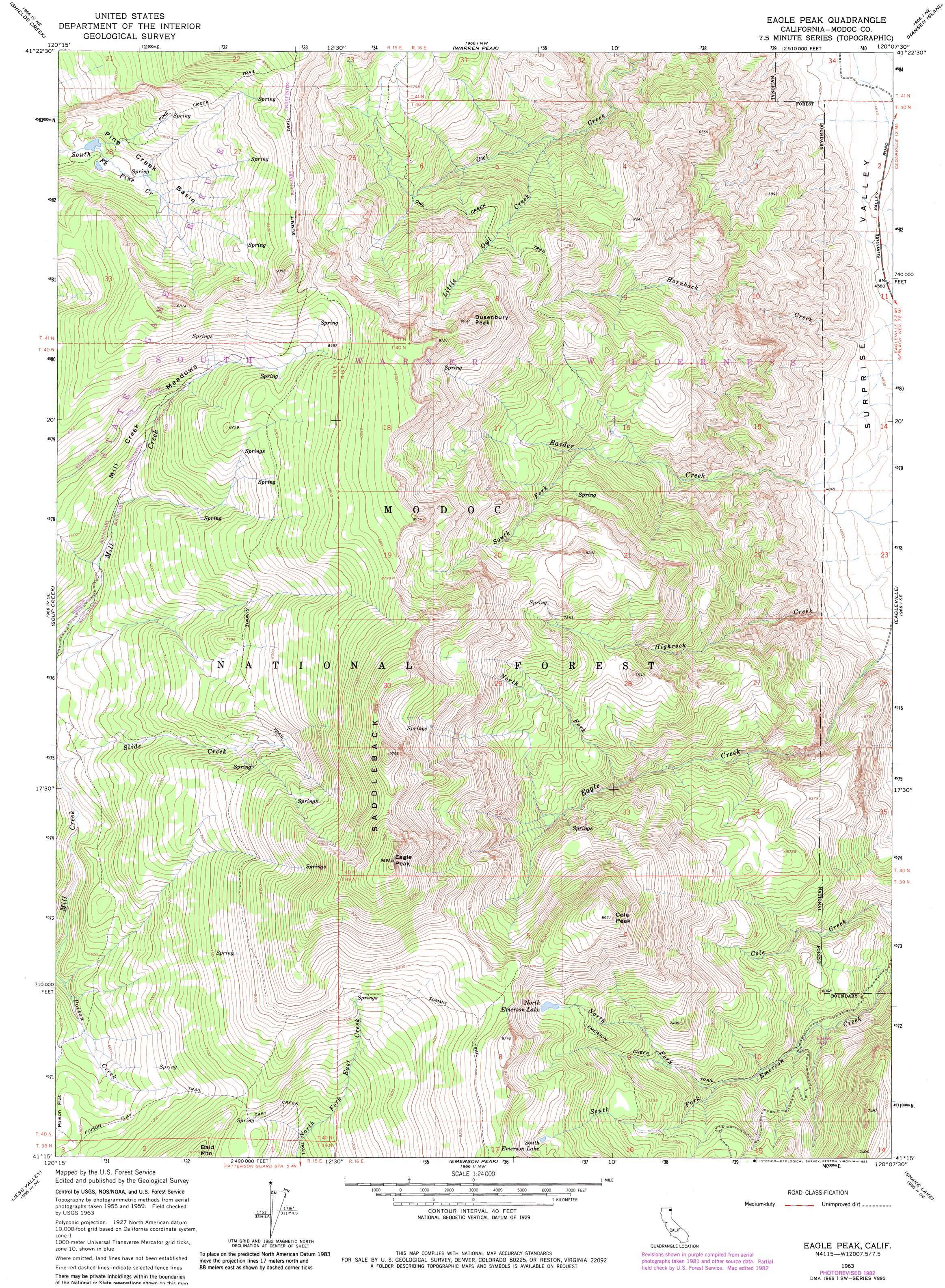
USGS Topo Quad 41120c2 - 1:24,000 scale
| Topo Map Name: | Eagle Peak |
| USGS Topo Quad ID: | 41120c2 |
| Print Size: | ca. 21 1/4" wide x 27" high |
| Southeast Coordinates: | 41.25° N latitude / 120.125° W longitude |
| Map Center Coordinates: | 41.3125° N latitude / 120.1875° W longitude |
| U.S. State: | CA |
| Filename: | o41120c2.jpg |
| Download Map JPG Image: | Eagle Peak topo map 1:24,000 scale |
| Map Type: | Topographic |
| Topo Series: | 7.5´ |
| Map Scale: | 1:24,000 |
| Source of Map Images: | United States Geological Survey (USGS) |
| Alternate Map Versions: |
Eagle Peak CA 1963, updated 1965 Download PDF Buy paper map Eagle Peak CA 1963, updated 1968 Download PDF Buy paper map Eagle Peak CA 1963, updated 1968 Download PDF Buy paper map Eagle Peak CA 1963, updated 1983 Download PDF Buy paper map Eagle Peak CA 1963, updated 1983 Download PDF Buy paper map Eagle Peak CA 1993, updated 1996 Download PDF Buy paper map Eagle Peak CA 2012 Download PDF Buy paper map Eagle Peak CA 2015 Download PDF Buy paper map |
| FStopo: | US Forest Service topo Eagle Peak is available: Download FStopo PDF Download FStopo TIF |
1:24,000 Topo Quads surrounding Eagle Peak
Surprise |
Payne Peak |
Cedarville |
Leonards Hot Springs |
Fortynine Mountain |
Dorris Reservoir |
Shields Creek |
Warren Peak |
Hansen Island |
Big Hat Mountain |
Little Juniper Reservoir |
Soup Creek |
Eagle Peak |
Eagleville |
Hays Canyon |
Tule Mountain |
Jess Valley |
Emerson Peak |
Snake Lake |
Pegleg Canyon |
Madeline |
Cold Spring Mountain |
Boot Lake |
Little Hat Mountain |
Duck Lake |
> Back to 41120a1 at 1:100,000 scale
> Back to 41120a1 at 1:250,000 scale
> Back to U.S. Topo Maps home
Eagle Peak topo map: Gazetteer
Eagle Peak: Basins
Pine Creek Basin elevation 2265m 7431′Eagle Peak: Flats
Mill Creek Meadows elevation 2308m 7572′Eagle Peak: Lakes
North Emerson Lake elevation 2359m 7739′South Emerson Lake elevation 2425m 7956′
Eagle Peak: Streams
Little Owl Creek elevation 1855m 6085′North Fork Eagle Creek elevation 1967m 6453′
North Fork Emerson Creek elevation 1938m 6358′
South Fork Emerson Creek elevation 1938m 6358′
South Fork Raider Creek elevation 2023m 6637′
Eagle Peak: Summits
Bald Mountain elevation 2346m 7696′Cole Peak elevation 2723m 8933′
Dusenbury Peak elevation 2768m 9081′
Eagle Peak elevation 3016m 9895′
Eagle Peak: Trails
Emerson Creek Trail elevation 2185m 7168′Pine Creek Trail elevation 2331m 7647′
Poison Flat Trail elevation 2072m 6797′
Summit Trail elevation 2377m 7798′
Eagle Peak digital topo map on disk
Buy this Eagle Peak topo map showing relief, roads, GPS coordinates and other geographical features, as a high-resolution digital map file on DVD: