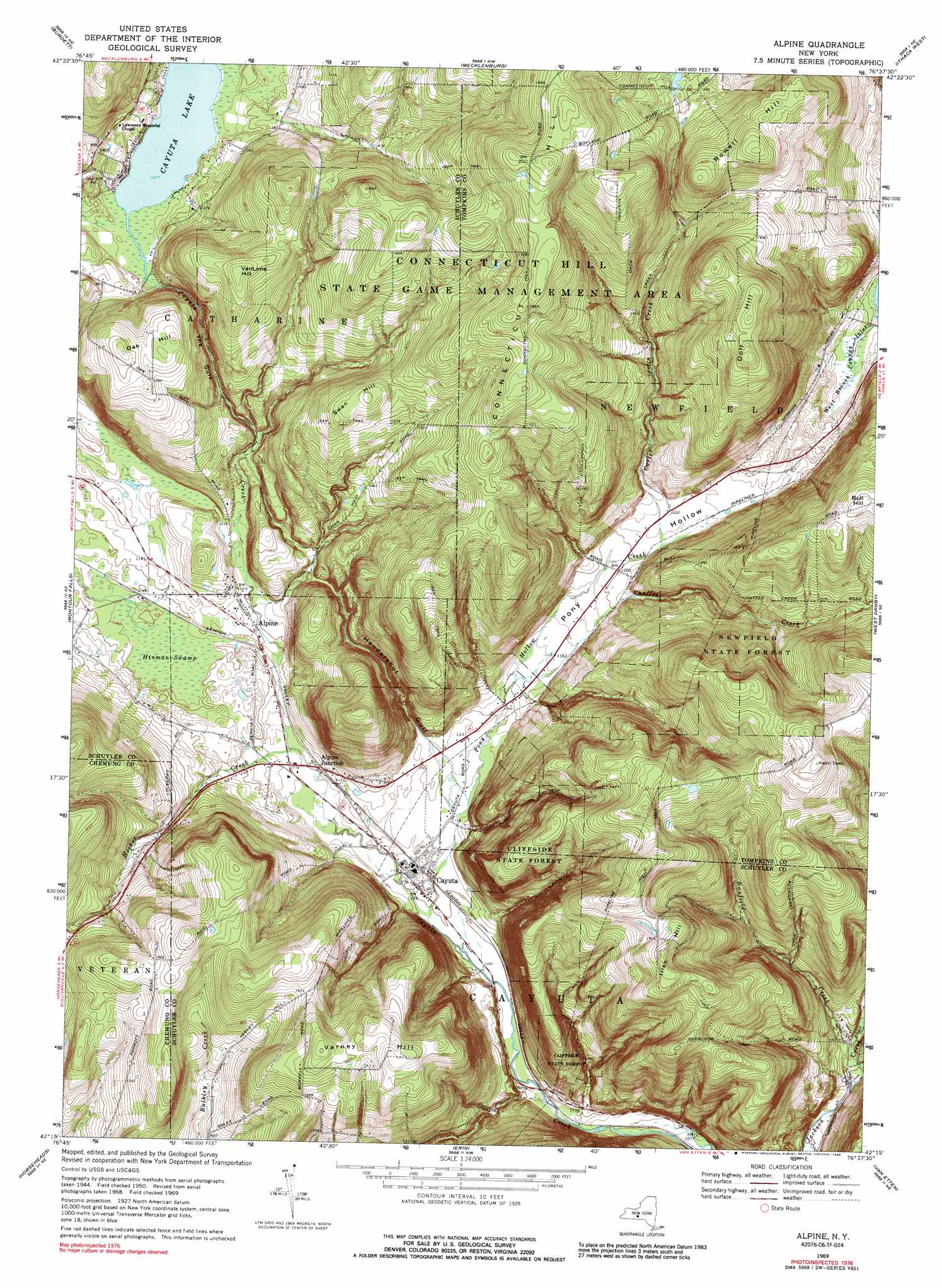
Alpine Topo Map New York
To zoom in, hover over the map of Alpine
USGS Topo Quad 42076c6 - 1:24,000 scale
| Topo Map Name: | Alpine |
| USGS Topo Quad ID: | 42076c6 |
| Print Size: | ca. 21 1/4" wide x 27" high |
| Southeast Coordinates: | 42.25° N latitude / 76.625° W longitude |
| Map Center Coordinates: | 42.3125° N latitude / 76.6875° W longitude |
| U.S. State: | NY |
| Filename: | o42076c6.jpg |
| Download Map JPG Image: | Alpine topo map 1:24,000 scale |
| Map Type: | Topographic |
| Topo Series: | 7.5´ |
| Map Scale: | 1:24,000 |
| Source of Map Images: | United States Geological Survey (USGS) |
| Alternate Map Versions: |
Alpine NY 1950, updated 1952 Download PDF Buy paper map Alpine NY 1950, updated 1964 Download PDF Buy paper map Alpine NY 1969, updated 1971 Download PDF Buy paper map Alpine NY 1969, updated 1976 Download PDF Buy paper map Alpine NY 1969, updated 1988 Download PDF Buy paper map Alpine NY 2010 Download PDF Buy paper map Alpine NY 2013 Download PDF Buy paper map Alpine NY 2016 Download PDF Buy paper map |
1:24,000 Topo Quads surrounding Alpine
Dundee |
Lodi |
Trumansburg |
Ludlowville |
West Groton |
Reading Center |
Burdett |
Mecklenburg |
Ithaca West |
Ithaca East |
Beaver Dams |
Montour Falls |
Alpine |
West Danby |
Willseyville |
Big Flats |
Horseheads |
Erin |
Van Etten |
Spencer |
Seeley Creek |
Elmira |
Wellsburg |
Waverly |
Barton |
> Back to 42076a1 at 1:100,000 scale
> Back to 42076a1 at 1:250,000 scale
> Back to U.S. Topo Maps home
Alpine topo map: Gazetteer
Alpine: Airports
Kayutah Lake Airport elevation 413m 1354′Alpine: Forests
Cliffside State Forest elevation 488m 1601′Newfield State Forest elevation 475m 1558′
Alpine: Lakes
Cayuta Lake elevation 401m 1315′Alpine: Parks
Connecticut Hill State Game Management Area elevation 544m 1784′Alpine: Populated Places
Alpine elevation 355m 1164′Alpine Junction elevation 344m 1128′
Cayuta elevation 336m 1102′
Wildwood Mobile Home Park elevation 359m 1177′
Alpine: Streams
Banfield Creek elevation 356m 1167′Carter Creek elevation 367m 1204′
Chaffee Creek elevation 351m 1151′
Hooker Creek elevation 338m 1108′
Pony Hollow Creek elevation 334m 1095′
Alpine: Summits
Doll Hill elevation 596m 1955′Irish Hill elevation 599m 1965′
Oak Hill elevation 510m 1673′
Rowell Hill elevation 561m 1840′
Swan Hill elevation 518m 1699′
VanLone Hill elevation 529m 1735′
Varney Hill elevation 562m 1843′
Alpine: Swamps
Hinman Swamp elevation 343m 1125′Alpine: Valleys
Hendershot Gulf elevation 345m 1131′Pony Hollow elevation 342m 1122′
The Gulf elevation 350m 1148′
Alpine digital topo map on disk
Buy this Alpine topo map showing relief, roads, GPS coordinates and other geographical features, as a high-resolution digital map file on DVD:
New York, Vermont, Connecticut & Western Massachusetts
Buy digital topo maps: New York, Vermont, Connecticut & Western Massachusetts