Willseyville Topo Map New York
To zoom in, hover over the map of Willseyville
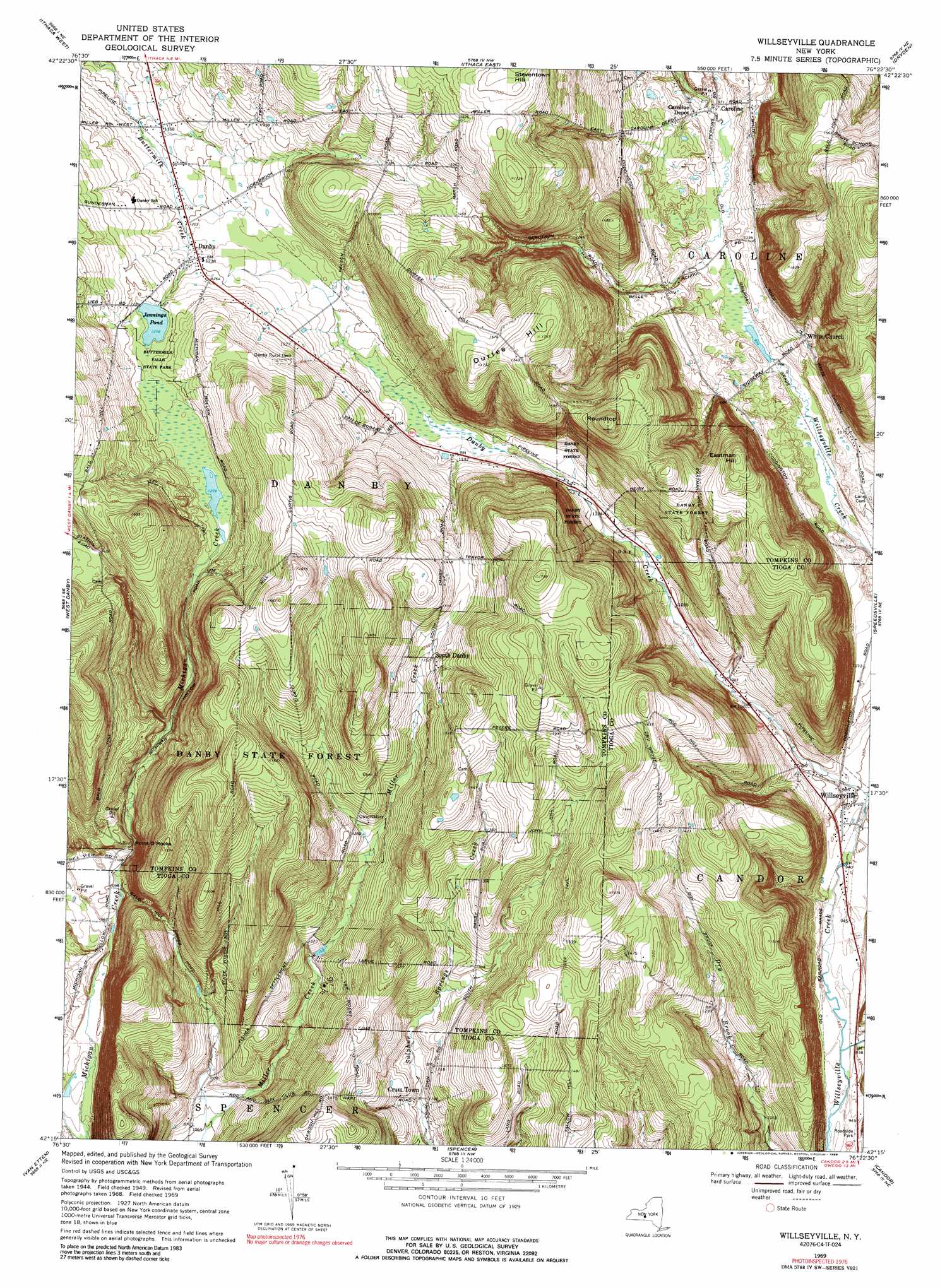
USGS Topo Quad 42076c4 - 1:24,000 scale
| Topo Map Name: | Willseyville |
| USGS Topo Quad ID: | 42076c4 |
| Print Size: | ca. 21 1/4" wide x 27" high |
| Southeast Coordinates: | 42.25° N latitude / 76.375° W longitude |
| Map Center Coordinates: | 42.3125° N latitude / 76.4375° W longitude |
| U.S. State: | NY |
| Filename: | o42076c4.jpg |
| Download Map JPG Image: | Willseyville topo map 1:24,000 scale |
| Map Type: | Topographic |
| Topo Series: | 7.5´ |
| Map Scale: | 1:24,000 |
| Source of Map Images: | United States Geological Survey (USGS) |
| Alternate Map Versions: |
Willseyville NY 1949, updated 1958 Download PDF Buy paper map Willseyville NY 1949, updated 1967 Download PDF Buy paper map Willseyville NY 1951 Download PDF Buy paper map Willseyville NY 1969, updated 1971 Download PDF Buy paper map Willseyville NY 1969, updated 1976 Download PDF Buy paper map Willseyville NY 1969, updated 1989 Download PDF Buy paper map Willseyville NY 1969, updated 1989 Download PDF Buy paper map Willseyville NY 2010 Download PDF Buy paper map Willseyville NY 2013 Download PDF Buy paper map Willseyville NY 2016 Download PDF Buy paper map |
1:24,000 Topo Quads surrounding Willseyville
Trumansburg |
Ludlowville |
West Groton |
Groton |
Cortland |
Mecklenburg |
Ithaca West |
Ithaca East |
Dryden |
Harford |
Alpine |
West Danby |
Willseyville |
Speedsville |
Richford |
Erin |
Van Etten |
Spencer |
Candor |
Newark Valley |
Wellsburg |
Waverly |
Barton |
Owego |
Apalachin |
> Back to 42076a1 at 1:100,000 scale
> Back to 42076a1 at 1:250,000 scale
> Back to U.S. Topo Maps home
Willseyville topo map: Gazetteer
Willseyville: Airports
Arsenaults Field elevation 483m 1584′Willseyville: Cliffs
Point O'Rocks elevation 339m 1112′Willseyville: Forests
Danby State Forest elevation 492m 1614′Willseyville: Lakes
Jennings Pond elevation 389m 1276′Willseyville: Parks
Buttermilk Falls State Park elevation 394m 1292′Willseyville: Populated Places
Caroline elevation 295m 967′Caroline Depot elevation 299m 980′
Crum Town elevation 354m 1161′
Danby elevation 377m 1236′
Hillview Terrace Mobile Home Park elevation 380m 1246′
South Danby elevation 413m 1354′
White Church elevation 330m 1082′
Willseyville elevation 289m 948′
Willseyville: Summits
Durfee Hill elevation 535m 1755′Eastman Hill elevation 512m 1679′
Roundtop elevation 547m 1794′
Willseyville digital topo map on disk
Buy this Willseyville topo map showing relief, roads, GPS coordinates and other geographical features, as a high-resolution digital map file on DVD:
New York, Vermont, Connecticut & Western Massachusetts
Buy digital topo maps: New York, Vermont, Connecticut & Western Massachusetts