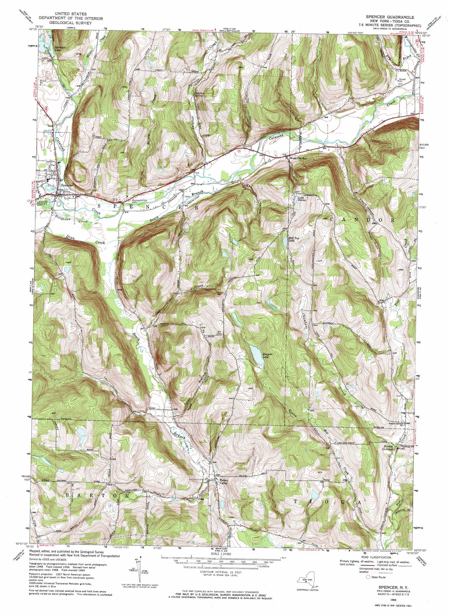
Spencer Topo Map New York
To zoom in, hover over the map of Spencer
USGS Topo Quad 42076b4 - 1:24,000 scale
| Topo Map Name: | Spencer |
| USGS Topo Quad ID: | 42076b4 |
| Print Size: | ca. 21 1/4" wide x 27" high |
| Southeast Coordinates: | 42.125° N latitude / 76.375° W longitude |
| Map Center Coordinates: | 42.1875° N latitude / 76.4375° W longitude |
| U.S. State: | NY |
| Filename: | o42076b4.jpg |
| Download Map JPG Image: | Spencer topo map 1:24,000 scale |
| Map Type: | Topographic |
| Topo Series: | 7.5´ |
| Map Scale: | 1:24,000 |
| Source of Map Images: | United States Geological Survey (USGS) |
| Alternate Map Versions: |
Spencer NY 1956, updated 1958 Download PDF Buy paper map Spencer NY 1969, updated 1971 Download PDF Buy paper map Spencer NY 1969, updated 1972 Download PDF Buy paper map Spencer NY 1969, updated 1972 Download PDF Buy paper map Spencer NY 2010 Download PDF Buy paper map Spencer NY 2013 Download PDF Buy paper map Spencer NY 2016 Download PDF Buy paper map |
1:24,000 Topo Quads surrounding Spencer
Mecklenburg |
Ithaca West |
Ithaca East |
Dryden |
Harford |
Alpine |
West Danby |
Willseyville |
Speedsville |
Richford |
Erin |
Van Etten |
Spencer |
Candor |
Newark Valley |
Wellsburg |
Waverly |
Barton |
Owego |
Apalachin |
Bentley Creek |
Sayre |
Litchfield |
Windham |
Little Meadows |
> Back to 42076a1 at 1:100,000 scale
> Back to 42076a1 at 1:250,000 scale
> Back to U.S. Topo Maps home
Spencer topo map: Gazetteer
Spencer: Airports
Kohn Airport elevation 349m 1145′Saikkonen Airport elevation 295m 967′
Spencer: Lakes
Empire Lake elevation 418m 1371′Lake Diana elevation 382m 1253′
Spencer: Parks
Nichols Park elevation 301m 987′Spencer: Populated Places
Halsey Valley elevation 325m 1066′Spencer elevation 303m 994′
Straits Corners elevation 324m 1062′
West Candor elevation 295m 967′
Spencer: Reservoirs
Hill Top Lake elevation 421m 1381′Nichols Pond elevation 299m 980′
Spencer: Springs
Sulphur Spring elevation 317m 1040′Spencer: Streams
Bliven Creek elevation 294m 964′Chambers Creek elevation 324m 1062′
Dean Creek elevation 295m 967′
Dry Brook elevation 278m 912′
Michigan Creek elevation 306m 1003′
Miller Creek elevation 306m 1003′
Owl Creek elevation 299m 980′
Seelytown Creek elevation 297m 974′
South Branch Catatonk Creek elevation 291m 954′
Sulphur Springs Creek elevation 294m 964′
Spencer: Valleys
Gay Hollow elevation 298m 977′Tyler Hollow elevation 316m 1036′
Spencer digital topo map on disk
Buy this Spencer topo map showing relief, roads, GPS coordinates and other geographical features, as a high-resolution digital map file on DVD:
New York, Vermont, Connecticut & Western Massachusetts
Buy digital topo maps: New York, Vermont, Connecticut & Western Massachusetts