Lowell Topo Map Michigan
To zoom in, hover over the map of Lowell
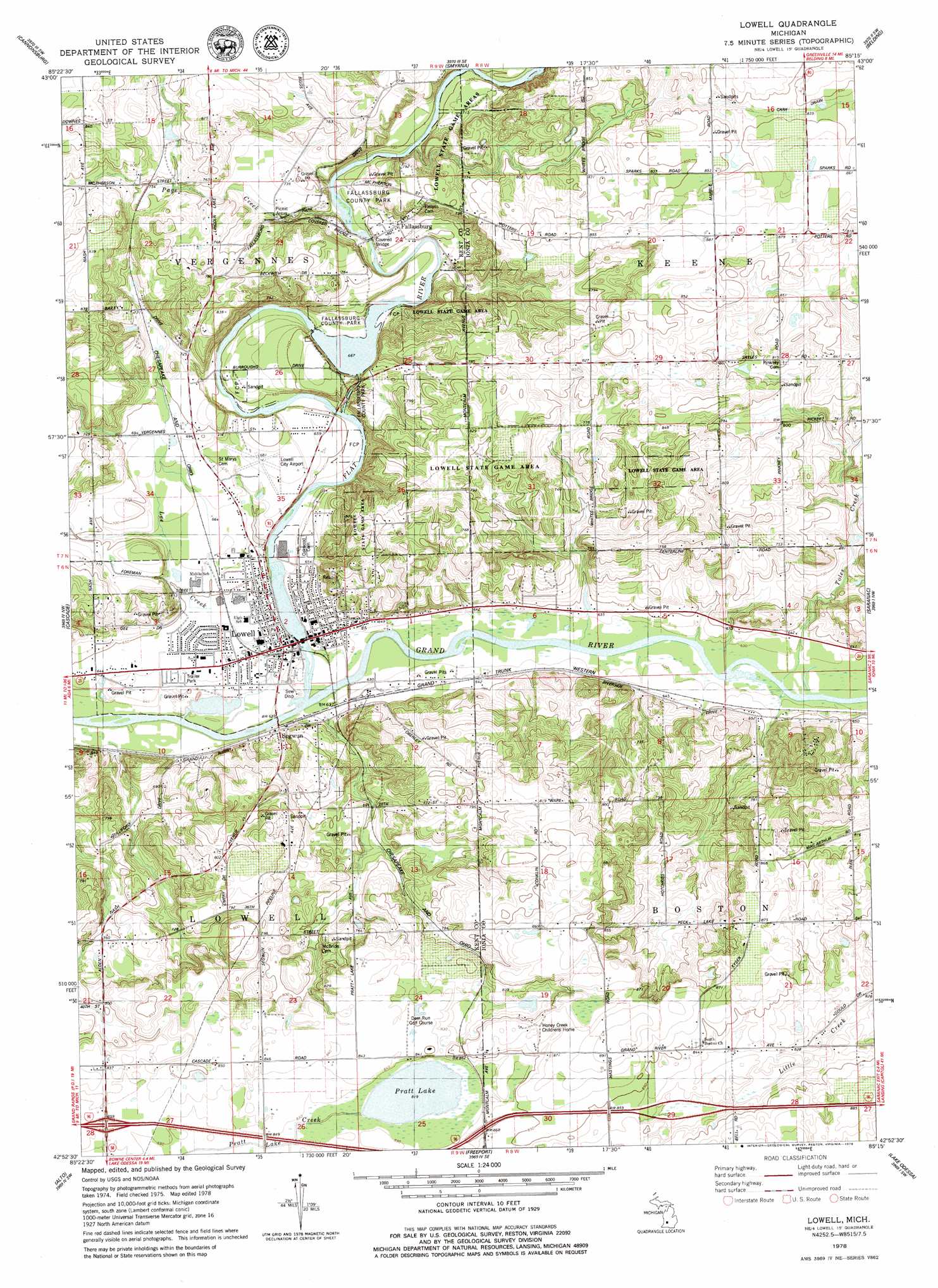
USGS Topo Quad 42085h3 - 1:24,000 scale
| Topo Map Name: | Lowell |
| USGS Topo Quad ID: | 42085h3 |
| Print Size: | ca. 21 1/4" wide x 27" high |
| Southeast Coordinates: | 42.875° N latitude / 85.25° W longitude |
| Map Center Coordinates: | 42.9375° N latitude / 85.3125° W longitude |
| U.S. State: | MI |
| Filename: | o42085h3.jpg |
| Download Map JPG Image: | Lowell topo map 1:24,000 scale |
| Map Type: | Topographic |
| Topo Series: | 7.5´ |
| Map Scale: | 1:24,000 |
| Source of Map Images: | United States Geological Survey (USGS) |
| Alternate Map Versions: |
Lowell MI 1978, updated 1979 Download PDF Buy paper map Lowell MI 2011 Download PDF Buy paper map Lowell MI 2014 Download PDF Buy paper map Lowell MI 2016 Download PDF Buy paper map |
1:24,000 Topo Quads surrounding Lowell
Cedar Springs |
Evans |
Greenville West |
Greenville East |
Sheridan |
Rockford |
Cannonsburg |
Smyrna |
Belding |
Shiloh |
Grand Rapids East |
Cascade |
Lowell |
Saranac |
Ionia |
Caledonia |
Alto |
Freeport |
Lake Odessa |
Woodbury |
Bowens Mill |
Middleville |
Hastings |
Woodland |
Saubee Lake |
> Back to 42085e1 at 1:100,000 scale
> Back to 42084a1 at 1:250,000 scale
> Back to U.S. Topo Maps home
Lowell topo map: Gazetteer
Lowell: Airports
Lowell City Airport elevation 207m 679′Lowell: Canals
Carr Drain elevation 256m 839′Lowell: Crossings
Interchange 52 elevation 257m 843′Lowell: Lakes
Natures Place Lake elevation 200m 656′Pratt Lake elevation 249m 816′
Stoney Lake elevation 187m 613′
Swan Ponds elevation 237m 777′
Lowell: Parks
Cooper Woodland Preserve elevation 208m 682′Creekside Park elevation 198m 649′
Fallasburg County Park elevation 210m 688′
Fallasburg Covered Bridge Historical Marker elevation 209m 685′
Fallasburg Pioneer Village Historical Marker elevation 227m 744′
Grand River Riverfront Park elevation -1m -4′
John W Fallas Historical Marker elevation 215m 705′
John Wesley Fallas House Historical Marker elevation 215m 705′
Lowell State Game Area elevation 253m 830′
McMahen Park elevation 234m 767′
Recreation Park elevation 190m 623′
Richards Park elevation 195m 639′
Robert W Graham Home Historical Marker elevation 192m 629′
Rogers Field elevation 192m 629′
Stoney Lakeside Park and Dog Park elevation 196m 643′
Upper Bridge Park elevation 189m 620′
Lowell: Populated Places
Fallassburg elevation 216m 708′Lowell elevation 193m 633′
Segwun elevation 195m 639′
Valley Vista Mobile Home Park elevation 194m 636′
Lowell: Post Offices
Avon Post Office (historical) elevation 264m 866′Fallassburg Post Office (historical) elevation 216m 708′
Lowell Post Office elevation 192m 629′
South Boston Post Office (historical) elevation 256m 839′
Lowell: Streams
Dairy Farm Creek elevation 206m 675′Flat River elevation 190m 623′
Lee Creek elevation 189m 620′
Page Creek elevation 208m 682′
Pratt Lake Creek elevation 249m 816′
Toles Creek elevation 190m 623′
Lowell digital topo map on disk
Buy this Lowell topo map showing relief, roads, GPS coordinates and other geographical features, as a high-resolution digital map file on DVD:
Northern Illinois, Northern Indiana & Southwestern Michigan
Buy digital topo maps: Northern Illinois, Northern Indiana & Southwestern Michigan