Wilderville Topo Map Oregon
To zoom in, hover over the map of Wilderville
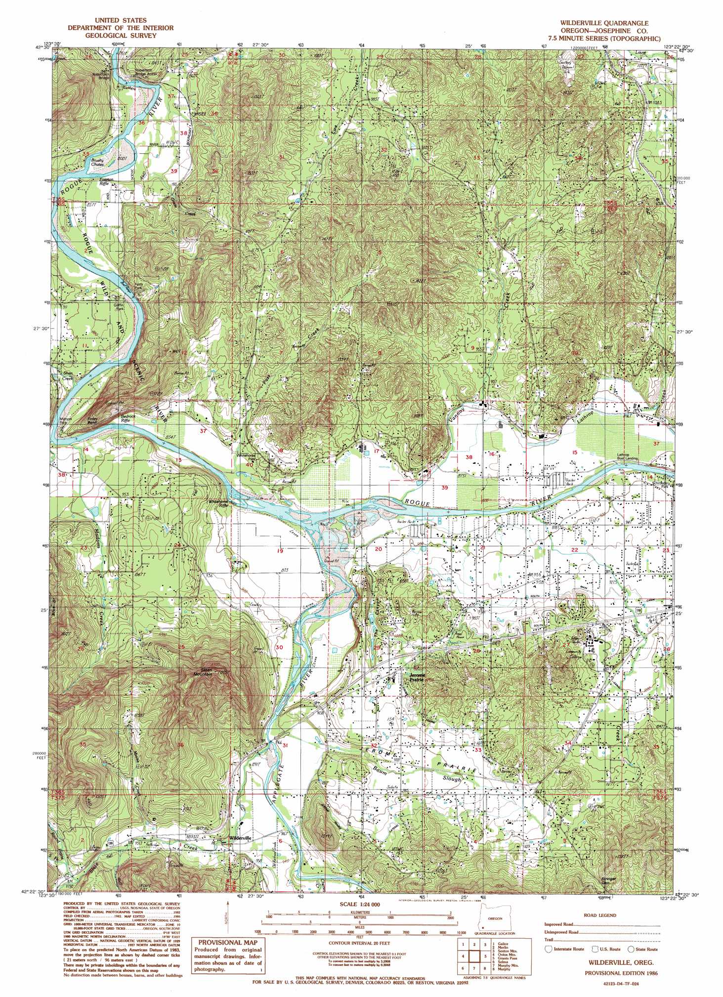
USGS Topo Quad 42123d4 - 1:24,000 scale
| Topo Map Name: | Wilderville |
| USGS Topo Quad ID: | 42123d4 |
| Print Size: | ca. 21 1/4" wide x 27" high |
| Southeast Coordinates: | 42.375° N latitude / 123.375° W longitude |
| Map Center Coordinates: | 42.4375° N latitude / 123.4375° W longitude |
| U.S. State: | OR |
| Filename: | o42123d4.jpg |
| Download Map JPG Image: | Wilderville topo map 1:24,000 scale |
| Map Type: | Topographic |
| Topo Series: | 7.5´ |
| Map Scale: | 1:24,000 |
| Source of Map Images: | United States Geological Survey (USGS) |
| Alternate Map Versions: |
Grants Pass NW OR 1974, updated 1977 Download PDF Buy paper map Wilderville OR 1986, updated 1986 Download PDF Buy paper map Wilderville OR 1996, updated 1999 Download PDF Buy paper map Wilderville OR 2011 Download PDF Buy paper map Wilderville OR 2014 Download PDF Buy paper map |
| FStopo: | US Forest Service topo Wilderville is available: Download FStopo PDF Download FStopo TIF |
1:24,000 Topo Quads surrounding Wilderville
Bunker Creek |
Mount Reuben |
Glendale |
Golden |
King Mountain |
Mount Peavine |
Galice |
Merlin |
Sexton Mountain |
Wimer |
Chrome Ridge |
Onion Mountain |
Wilderville |
Grants Pass |
Rogue River |
Eight Dollar Mountain |
Selma |
Murphy Mountain |
Murphy |
Applegate |
Cave Junction |
Holland |
Kerby Peak |
Williams |
Tallowbox Mountain |
> Back to 42123a1 at 1:100,000 scale
> Back to 42122a1 at 1:250,000 scale
> Back to U.S. Topo Maps home
Wilderville topo map: Gazetteer
Wilderville: Bends
Finley Bend elevation 254m 833′Wilderville: Bridges
Robertson Bridge elevation 241m 790′Wilderville: Canals
Jerome Prairie Lateral elevation 319m 1046′The Drain elevation 267m 875′
Wilderville: Dams
Werner Dam elevation 346m 1135′Wilderville: Flats
Jerome Prairie elevation 298m 977′Wilderville: Gaps
Stringer Gap elevation 388m 1272′Wilderville: Parks
Ferry County Park elevation 255m 836′Griffin County Park elevation 254m 833′
Lathrop County Park elevation 269m 882′
Matson County Park elevation 255m 836′
Robertson Bridge County Park elevation 244m 800′
Schroeder County Park elevation 272m 892′
Whitehorse County Park elevation 269m 882′
Wilderville: Populated Places
Redwood elevation 285m 935′Wilderville elevation 281m 921′
Wilderville: Post Offices
Booth Post Office (historical) elevation 246m 807′Vannoy Post Office (historical) elevation 262m 859′
Wilderville Post Office elevation 281m 921′
Wilderville: Rapids
Bedrock Riffle elevation 254m 833′Brushy Chutes elevation 246m 807′
Everton Riffle elevation 246m 807′
Whitehorse Riffle elevation 265m 869′
Wilderville: Reservoirs
Apple Rogue Reservoir elevation 277m 908′Aqua Fria Reservoir elevation 323m 1059′
Daily Reservoir elevation 359m 1177′
Klose Pond elevation 262m 859′
Steppe Reservoir elevation 308m 1010′
Wee Bonnie Loch Glen Reservoir elevation 288m 944′
Werner Reservoir elevation 346m 1135′
Wilderville: Streams
Applegate River elevation 259m 849′Baum Slough elevation 269m 882′
Britton Creek elevation 269m 882′
Carter Creek elevation 292m 958′
Chapin Creek elevation 275m 902′
Grade Creek elevation 252m 826′
Haven Creek elevation 274m 898′
Lathrop Creek elevation 278m 912′
Madams Creek elevation 256m 839′
Minnie Creek elevation 288m 944′
Pass Creek elevation 257m 843′
Pickett Creek elevation 241m 790′
Rich Creek elevation 254m 833′
Robertson Creek elevation 245m 803′
Round Prairie Creek elevation 297m 974′
Sand Creek elevation 269m 882′
Shan Creek elevation 253m 830′
Slate Creek elevation 273m 895′
South Fork Round Prairie Creek elevation 303m 994′
Sparrowhawk Creek elevation 263m 862′
Vannoy Creek elevation 263m 862′
Wilderville: Summits
Sloan Mountain elevation 631m 2070′Wilderville: Valleys
Frosty Canyon elevation 318m 1043′Knights Gulch elevation 288m 944′
Rail Canyon elevation 294m 964′
The Canyon elevation 269m 882′
Wilderville digital topo map on disk
Buy this Wilderville topo map showing relief, roads, GPS coordinates and other geographical features, as a high-resolution digital map file on DVD: