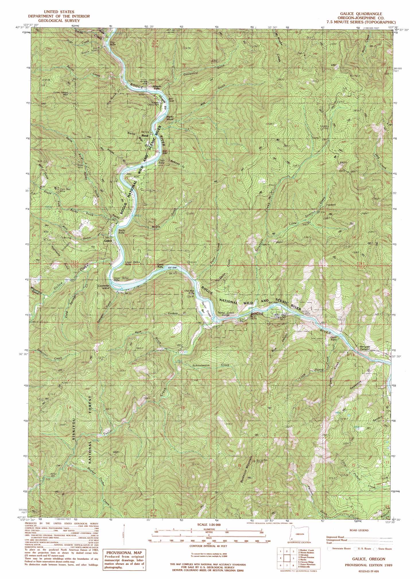
Galice Topo Map Oregon
To zoom in, hover over the map of Galice
USGS Topo Quad 42123e5 - 1:24,000 scale
| Topo Map Name: | Galice |
| USGS Topo Quad ID: | 42123e5 |
| Print Size: | ca. 21 1/4" wide x 27" high |
| Southeast Coordinates: | 42.5° N latitude / 123.5° W longitude |
| Map Center Coordinates: | 42.5625° N latitude / 123.5625° W longitude |
| U.S. State: | OR |
| Filename: | o42123e5.jpg |
| Download Map JPG Image: | Galice topo map 1:24,000 scale |
| Map Type: | Topographic |
| Topo Series: | 7.5´ |
| Map Scale: | 1:24,000 |
| Source of Map Images: | United States Geological Survey (USGS) |
| Alternate Map Versions: |
Galice OR 1989, updated 1989 Download PDF Buy paper map Galice OR 1998, updated 2001 Download PDF Buy paper map Galice OR 2011 Download PDF Buy paper map Galice OR 2014 Download PDF Buy paper map |
| FStopo: | US Forest Service topo Galice is available: Download FStopo PDF Download FStopo TIF |
1:24,000 Topo Quads surrounding Galice
Mount Bolivar |
Dutchman Butte |
Rabbit Mountain |
Mccullough Creek |
Quines Creek |
Kelsey Peak |
Bunker Creek |
Mount Reuben |
Glendale |
Golden |
Hobson Horn |
Mount Peavine |
Galice |
Merlin |
Sexton Mountain |
York Butte |
Chrome Ridge |
Onion Mountain |
Wilderville |
Grants Pass |
Pearsoll Peak |
Eight Dollar Mountain |
Selma |
Murphy Mountain |
Murphy |
> Back to 42123e1 at 1:100,000 scale
> Back to 42122a1 at 1:250,000 scale
> Back to U.S. Topo Maps home
Galice topo map: Gazetteer
Galice: Bars
Almeda Bar elevation 255m 836′Taylor Creek Bar elevation 227m 744′
Galice: Bridges
Hellgate Bridge elevation 227m 744′Galice: Islands
Carpenters Island elevation 221m 725′Marks Island elevation 222m 728′
Galice: Mines
Almeda Mine elevation 269m 882′Black Bear Mine elevation 594m 1948′
Golden Wedge Mine elevation 636m 2086′
Old Channel Mine elevation 487m 1597′
Oriole Mine elevation 455m 1492′
Seven-Thirty Mine elevation 876m 2874′
Galice: Parks
Almeda County Park elevation 255m 836′Argo County Park elevation 196m 643′
Carpenters Island Park elevation 215m 705′
Ennis Riffle County Park elevation 218m 715′
Hog Creek County Park elevation 245m 803′
Indian Mary County Park elevation 265m 869′
Rand Recreation Area elevation 210m 688′
Galice: Populated Places
Galice elevation 243m 797′Rand elevation 249m 816′
Galice: Post Offices
Almeda Post Office (historical) elevation 205m 672′Galice Post Office (historical) elevation 243m 797′
Galice: Rapids
Argo Riffle elevation 194m 636′Armedio Riffle elevation 200m 656′
Chair Riffle elevation 203m 666′
Dunn Riffle elevation 225m 738′
Ennis Riffle elevation 224m 734′
Galice Riffle elevation 212m 695′
Lower Galice Riffle elevation 211m 692′
Old Man Riffle elevation 217m 711′
Rocky Riffle elevation 209m 685′
Upper Galice Riffle elevation 212m 695′
Galice: Springs
Fraser Spring elevation 310m 1017′Friday Spring elevation 345m 1131′
Galice: Streams
Argo Creek elevation 219m 718′Bailey Creek elevation 222m 728′
Burned Timber Creek elevation 388m 1272′
Cold Springs Creek elevation 240m 787′
Delta Creek elevation 217m 711′
Galice Creek elevation 225m 738′
Hog Creek elevation 245m 803′
Keyte Creek elevation 246m 807′
Little Stratton Creek elevation 426m 1397′
Little Zigzag Creek elevation 248m 813′
Mouse Creek elevation 214m 702′
Paint Creek elevation 231m 757′
Phipps Creek elevation 352m 1154′
Schoolmarm Creek elevation 294m 964′
Smith Creek elevation 196m 643′
South Fork Argo Creek elevation 304m 997′
South Fork Galice Creek elevation 277m 908′
Stratton Creek elevation 234m 767′
Taylor Creek elevation 221m 725′
Waterspout Creek elevation 213m 698′
Yew Wood Creek elevation 250m 820′
Zigzag Creek elevation 232m 761′
Galice: Summits
Buckhorn Mountain elevation 1114m 3654′Old Channel elevation 410m 1345′
Galice: Trails
Coffee Pot Trail elevation 745m 2444′Galice: Valleys
Applegate Gulch elevation 247m 810′Ash Gulch elevation 201m 659′
Bear Gulch elevation 590m 1935′
Belknap Gulch elevation 203m 666′
Blanchard Gulch elevation 272m 892′
Blue Canyon elevation 247m 810′
Buck Gulch elevation 247m 810′
Centennial Creek elevation 236m 774′
Cooksie Gulch elevation 218m 715′
Hellgate Canyon elevation 227m 744′
Hooks Gulch elevation 257m 843′
Maple Gulch elevation 230m 754′
North Fork Rocky Gulch elevation 267m 875′
North Star Gulch elevation 203m 666′
Patrick Gulch elevation 504m 1653′
Red Gulch elevation 227m 744′
Rich Gulch elevation 417m 1368′
Rocky Gulch elevation 220m 721′
Sanders Gulch elevation 250m 820′
Serpentine Gulch elevation 232m 761′
South Fork Rocky Gulch elevation 267m 875′
Spangler Gulch elevation 215m 705′
Spring Gulch elevation 383m 1256′
Taylor Creek Gorge elevation 250m 820′
Toss Gulch elevation 217m 711′
Galice digital topo map on disk
Buy this Galice topo map showing relief, roads, GPS coordinates and other geographical features, as a high-resolution digital map file on DVD: