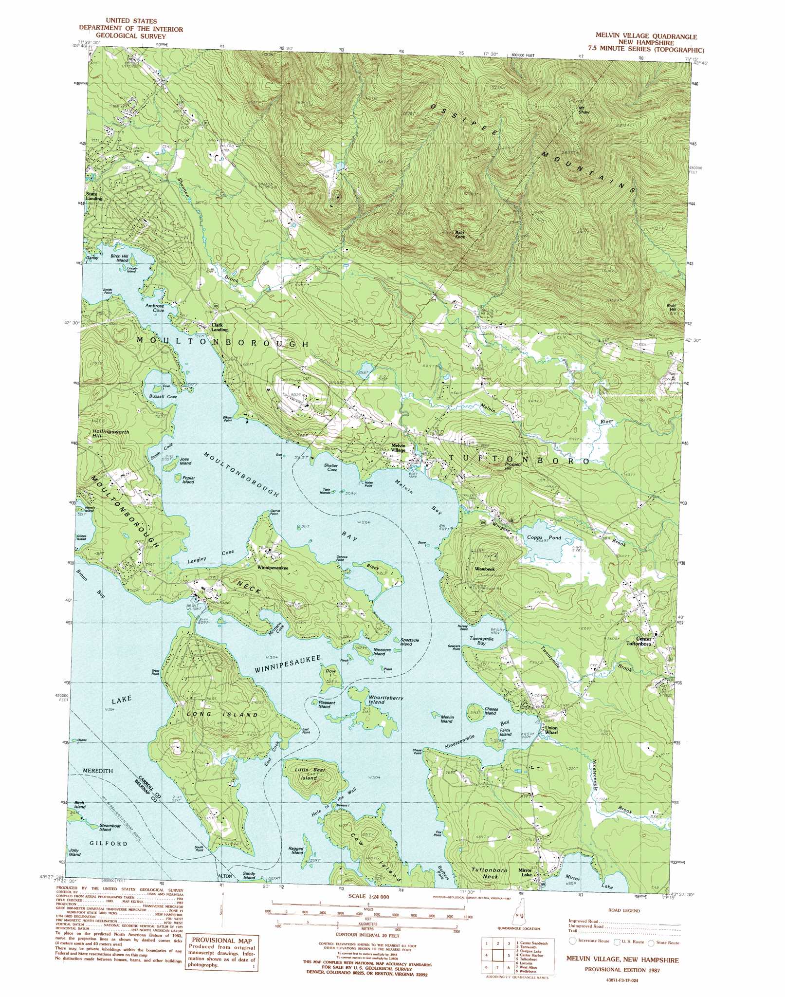
Melvin Village Topo Map New Hampshire
To zoom in, hover over the map of Melvin Village
USGS Topo Quad 43071f3 - 1:24,000 scale
| Topo Map Name: | Melvin Village |
| USGS Topo Quad ID: | 43071f3 |
| Print Size: | ca. 21 1/4" wide x 27" high |
| Southeast Coordinates: | 43.625° N latitude / 71.25° W longitude |
| Map Center Coordinates: | 43.6875° N latitude / 71.3125° W longitude |
| U.S. State: | NH |
| Filename: | o43071f3.jpg |
| Download Map JPG Image: | Melvin Village topo map 1:24,000 scale |
| Map Type: | Topographic |
| Topo Series: | 7.5´ |
| Map Scale: | 1:24,000 |
| Source of Map Images: | United States Geological Survey (USGS) |
| Alternate Map Versions: |
Melvin Village NH 1987, updated 1987 Download PDF Buy paper map Melvin Village NH 2012 Download PDF Buy paper map Melvin Village NH 2015 Download PDF Buy paper map |
1:24,000 Topo Quads surrounding Melvin Village
Waterville Valley |
Mount Tripyramid |
Mount Chocorua |
Silver Lake |
Conway |
Squam Mountains |
Center Sandwich |
Tamworth |
Ossipee Lake |
Freedom |
Holderness |
Center Harbor |
Melvin Village |
Tuftonboro |
Ossipee |
Winnisquam Lake |
Laconia |
West Alton |
Wolfeboro |
Sanbornville |
Northfield |
Belmont |
Gilmanton Ironworks |
Alton |
Farmington |
> Back to 43071e1 at 1:100,000 scale
> Back to 43070a1 at 1:250,000 scale
> Back to U.S. Topo Maps home
Melvin Village topo map: Gazetteer
Melvin Village: Airports
Arthurs Seaplane Base elevation 153m 501′Flying H Skyport elevation 175m 574′
Loons Nest Seaplane Base elevation 155m 508′
Melvin Village Airport elevation 195m 639′
Melvin Village: Bays
Ambrose Cove elevation 154m 505′Braun Bay elevation 153m 501′
Buzzell Cove elevation 153m 501′
East Cove elevation 153m 501′
Langley Cove elevation 153m 501′
Melvin Bay elevation 153m 501′
Morrison Cove elevation 153m 501′
Moultonborough Bay elevation 153m 501′
Nineteenmile Bay elevation 153m 501′
Shelter Cove elevation 153m 501′
Smith Cove elevation 153m 501′
Twentymile Bay elevation 153m 501′
Melvin Village: Beaches
Moultonborough Town Beach elevation 153m 501′Melvin Village: Capes
Chase Point elevation 157m 515′East Point elevation 158m 518′
Elkins Point elevation 154m 505′
Fox Point elevation 153m 501′
Garnet Point elevation 156m 511′
Geneva Point elevation 155m 508′
Haley Point elevation 156m 511′
Hersey Point elevation 161m 528′
Moultonborough Neck elevation 222m 728′
Sawyers Point elevation 160m 524′
Smith Point elevation 159m 521′
South Point elevation 157m 515′
West Point elevation 158m 518′
Melvin Village: Channels
Barbers Pole elevation 153m 501′Hole in the Wall elevation 153m 501′
Melvin Village: Dams
Copps Pond Dam elevation 174m 570′Shannon Pond Dam elevation 380m 1246′
Melvin Village: Islands
Birch Hill Island elevation 156m 511′Birch Island elevation 158m 518′
Black Island elevation 156m 511′
Chases Island elevation 160m 524′
Cove Island elevation 153m 501′
Cow Island elevation 188m 616′
Devens Island elevation 155m 508′
Dow Island elevation 159m 521′
Farm Island elevation 160m 524′
Gun Island elevation 153m 501′
Gun Island elevation 159m 521′
Hermit Island elevation 154m 505′
Joes Island elevation 159m 521′
Lincoln Island elevation 154m 505′
Little Bear Island elevation 195m 639′
Long Island elevation 204m 669′
Loon Island elevation 153m 501′
Melvin Island elevation 154m 505′
Nineacre Island elevation 159m 521′
Ozone Island elevation 153m 501′
Perch Island elevation 154m 505′
Pistol Island elevation 153m 501′
Pleasant Island elevation 154m 505′
Poplar Island elevation 159m 521′
Ragged Island elevation 154m 505′
Spectacle Island elevation 153m 501′
Steamboat Island elevation 159m 521′
Store Island elevation 153m 501′
Swill Island elevation 153m 501′
Twin Islands elevation 154m 505′
Whortleberry Island elevation 157m 515′
Melvin Village: Parks
Copps Pond Wildlife Management Area elevation 172m 564′Melvin Village: Populated Places
Clark Landing elevation 160m 524′Melvin Village elevation 158m 518′
State Landing elevation 155m 508′
Union Wharf elevation 154m 505′
Wawbeek elevation 160m 524′
Winnipesaukee elevation 167m 547′
Melvin Village: Reservoirs
Copps Pond elevation 173m 567′Shannon Pond elevation 380m 1246′
Melvin Village: Streams
Melvin River elevation 154m 505′Nineteenmile Brook elevation 154m 505′
Twentymile Brook elevation 155m 508′
Wingate Brook elevation 154m 505′
Melvin Village: Summits
Bald Knob elevation 669m 2194′Brier Hill elevation 398m 1305′
Mount Shaw elevation 889m 2916′
Ossipee Mountain elevation 890m 2919′
Prospect Hill elevation 257m 843′
Melvin Village digital topo map on disk
Buy this Melvin Village topo map showing relief, roads, GPS coordinates and other geographical features, as a high-resolution digital map file on DVD:
Maine, New Hampshire, Rhode Island & Eastern Massachusetts
Buy digital topo maps: Maine, New Hampshire, Rhode Island & Eastern Massachusetts