Conway Topo Map New Hampshire
To zoom in, hover over the map of Conway
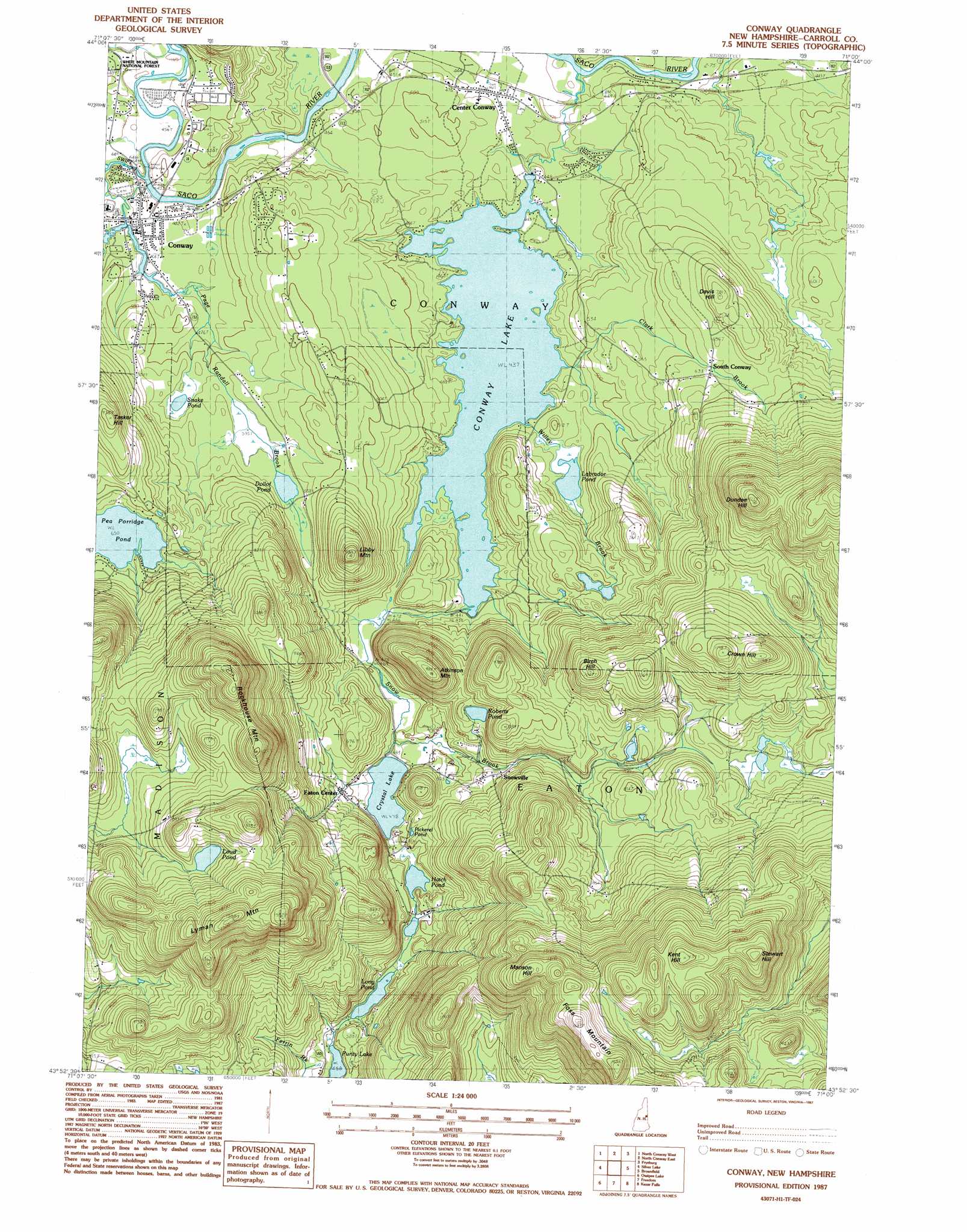
USGS Topo Quad 43071h1 - 1:24,000 scale
| Topo Map Name: | Conway |
| USGS Topo Quad ID: | 43071h1 |
| Print Size: | ca. 21 1/4" wide x 27" high |
| Southeast Coordinates: | 43.875° N latitude / 71° W longitude |
| Map Center Coordinates: | 43.9375° N latitude / 71.0625° W longitude |
| U.S. State: | NH |
| Filename: | o43071h1.jpg |
| Download Map JPG Image: | Conway topo map 1:24,000 scale |
| Map Type: | Topographic |
| Topo Series: | 7.5´ |
| Map Scale: | 1:24,000 |
| Source of Map Images: | United States Geological Survey (USGS) |
| Alternate Map Versions: |
Conway NH 1987, updated 1987 Download PDF Buy paper map Conway NH 1987, updated 1987 Download PDF Buy paper map Conway NH 1998, updated 2001 Download PDF Buy paper map Conway NH 2012 Download PDF Buy paper map Conway NH 2015 Download PDF Buy paper map |
| FStopo: | US Forest Service topo Conway is available: Download FStopo PDF Download FStopo TIF |
1:24,000 Topo Quads surrounding Conway
Stairs Mountain |
Jackson |
Chatham |
Center Lovell |
North Waterford |
Bartlett |
North Conway West |
North Conway East |
Fryeburg |
Pleasant Mountain |
Mount Chocorua |
Silver Lake |
Conway |
Brownfield |
Hiram |
Tamworth |
Ossipee Lake |
Freedom |
Kezar Falls |
Cornish |
Melvin Village |
Tuftonboro |
Ossipee |
West Newfield |
Limerick |
> Back to 43071e1 at 1:100,000 scale
> Back to 43070a1 at 1:250,000 scale
> Back to U.S. Topo Maps home
Conway topo map: Gazetteer
Conway: Bridges
Saco River Covered Bridge elevation 162m 531′Swift River Bridge elevation 135m 442′
Conway: Dams
Conway Lake Dam elevation 133m 436′Pequawket Power Company Dam elevation 140m 459′
Conway: Lakes
Crystal Lake elevation 146m 479′Dollof Pond elevation 179m 587′
Hatch Pond elevation 146m 479′
Labrador Pond elevation 139m 456′
Long Pond elevation 145m 475′
Loud Pond elevation 336m 1102′
Pea Porridge Pond elevation 198m 649′
Pickerel Pond elevation 152m 498′
Roberts Pond elevation 201m 659′
Snake Pond elevation 161m 528′
Conway: Populated Places
Center Conway elevation 140m 459′Conway elevation 140m 459′
Eaton Center elevation 167m 547′
Snowville elevation 177m 580′
South Conway elevation 190m 623′
Conway: Post Offices
Center Conway Post Office elevation 137m 449′Conway Post Office elevation 141m 462′
Conway: Reservoirs
Conway Lake elevation 133m 436′Pequawket Pond elevation 140m 459′
Conway: Ridges
Foss Mountain elevation 465m 1525′Lyman Mountain elevation 471m 1545′
Rockhouse Mountain elevation 347m 1138′
Conway: Streams
Clark Brook elevation 133m 436′Grove Brook elevation 154m 505′
Page Randall Brook elevation 140m 459′
Snow Brook elevation 127m 416′
Swift River elevation 139m 456′
Willey Brook elevation 133m 436′
Conway: Summits
Atkinson Mountain elevation 286m 938′Birch Hill elevation 296m 971′
Crown Hill elevation 355m 1164′
Davis Hill elevation 234m 767′
Dundee Hill elevation 419m 1374′
Kent Hill elevation 490m 1607′
Libby Mountain elevation 239m 784′
Manson Hill elevation 447m 1466′
Stewart Hill elevation 495m 1624′
Conway digital topo map on disk
Buy this Conway topo map showing relief, roads, GPS coordinates and other geographical features, as a high-resolution digital map file on DVD:
Maine, New Hampshire, Rhode Island & Eastern Massachusetts
Buy digital topo maps: Maine, New Hampshire, Rhode Island & Eastern Massachusetts