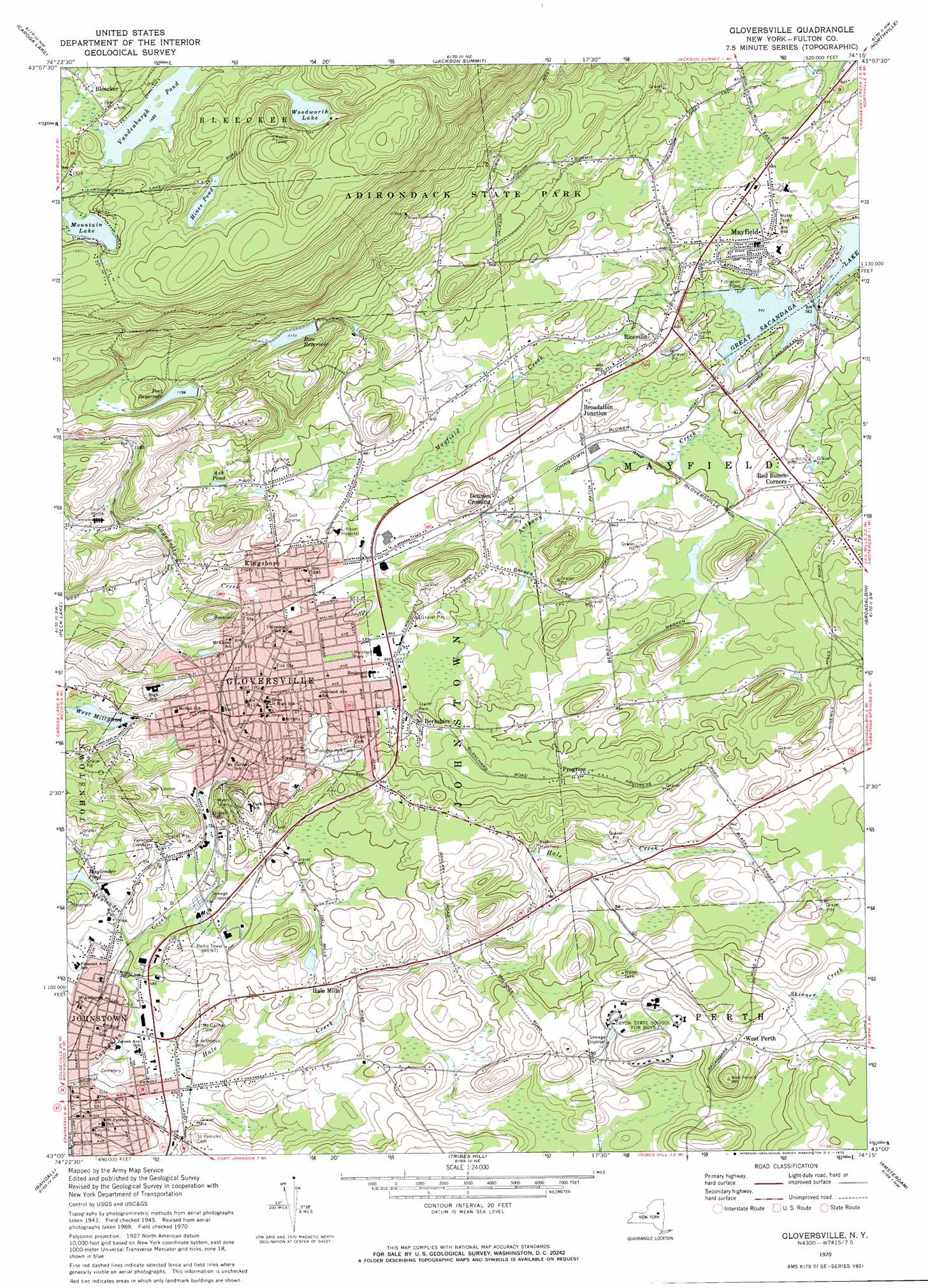
Gloversville Topo Map New York
To zoom in, hover over the map of Gloversville
USGS Topo Quad 43074a3 - 1:24,000 scale
| Topo Map Name: | Gloversville |
| USGS Topo Quad ID: | 43074a3 |
| Print Size: | ca. 21 1/4" wide x 27" high |
| Southeast Coordinates: | 43° N latitude / 74.25° W longitude |
| Map Center Coordinates: | 43.0625° N latitude / 74.3125° W longitude |
| U.S. State: | NY |
| Filename: | o43074a3.jpg |
| Download Map JPG Image: | Gloversville topo map 1:24,000 scale |
| Map Type: | Topographic |
| Topo Series: | 7.5´ |
| Map Scale: | 1:24,000 |
| Source of Map Images: | United States Geological Survey (USGS) |
| Alternate Map Versions: |
Gloversville NY 1945, updated 1966 Download PDF Buy paper map Gloversville NY 1946, updated 1946 Download PDF Buy paper map Gloversville NY 1963, updated 1963 Download PDF Buy paper map Gloversville NY 1970, updated 1972 Download PDF Buy paper map Gloversville NY 2010 Download PDF Buy paper map Gloversville NY 2013 Download PDF Buy paper map Gloversville NY 2016 Download PDF Buy paper map |
1:24,000 Topo Quads surrounding Gloversville
Tomany Mountain |
Cathead Mountain |
Ohmer Mountain |
||
Canada Lake |
Caroga Lake |
Jackson Summit |
Northville |
Edinburg |
Lassellsville |
Peck Lake |
Gloversville |
Broadalbin |
Galway |
Canajoharie |
Randall |
Tribes Hill |
Amsterdam |
Pattersonville |
Sharon Springs |
Carlisle |
Esperance |
Duanesburg |
Rotterdam Junction |
> Back to 43074a1 at 1:100,000 scale
> Back to 43074a1 at 1:250,000 scale
> Back to U.S. Topo Maps home
Gloversville topo map: Gazetteer
Gloversville: Lakes
Ash Pond elevation 295m 967′Hines Pond elevation 497m 1630′
Mountain Lake elevation 480m 1574′
Vandenburgh Pond elevation 452m 1482′
West Millpond elevation 254m 833′
Woodworth Lake elevation 510m 1673′
Gloversville: Parks
Charles Jenner Memorial Park elevation 213m 698′Darling Field (historical) elevation 261m 856′
Kingsboro Park elevation 272m 892′
Melchoir Park elevation 264m 866′
Myers Park elevation 270m 885′
Gloversville: Populated Places
Berkshire elevation 276m 905′Bleecker elevation 458m 1502′
Broadalbin Junction elevation 258m 846′
Dennies Crossing elevation 260m 853′
Gloversville elevation 250m 820′
Hale Mills elevation 225m 738′
Johnstown elevation 205m 672′
Kingsboro elevation 274m 898′
Mayfield elevation 259m 849′
Progress elevation 287m 941′
Red Bunch Corners elevation 252m 826′
Riceville elevation 255m 836′
West Perth elevation 263m 862′
Gloversville: Reservoirs
Ayres Hill Storage Reservoir elevation 309m 1013′Maylender Pond elevation 242m 793′
Port Reservoir elevation 349m 1145′
Rice Reservoir elevation 338m 1108′
Gloversville: Streams
Anthony Creek elevation 235m 770′Hale Creek elevation 199m 652′
Mayfield Creek elevation 235m 770′
Maylender Creek elevation 218m 715′
Gloversville digital topo map on disk
Buy this Gloversville topo map showing relief, roads, GPS coordinates and other geographical features, as a high-resolution digital map file on DVD:
New York, Vermont, Connecticut & Western Massachusetts
Buy digital topo maps: New York, Vermont, Connecticut & Western Massachusetts