Bay City Topo Map Michigan
To zoom in, hover over the map of Bay City
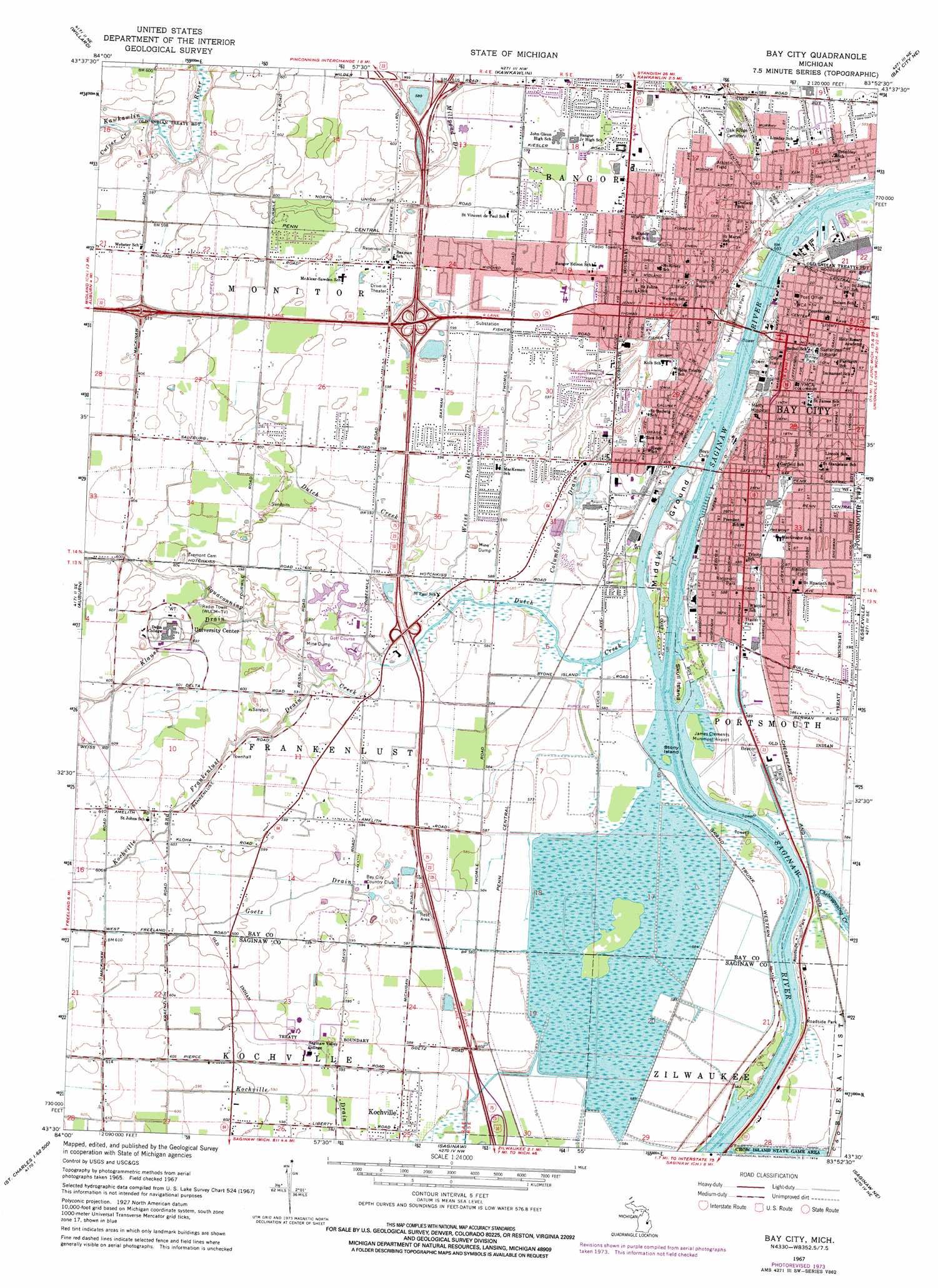
USGS Topo Quad 43083e8 - 1:24,000 scale
| Topo Map Name: | Bay City |
| USGS Topo Quad ID: | 43083e8 |
| Print Size: | ca. 21 1/4" wide x 27" high |
| Southeast Coordinates: | 43.5° N latitude / 83.875° W longitude |
| Map Center Coordinates: | 43.5625° N latitude / 83.9375° W longitude |
| U.S. State: | MI |
| Filename: | o43083e8.jpg |
| Download Map JPG Image: | Bay City topo map 1:24,000 scale |
| Map Type: | Topographic |
| Topo Series: | 7.5´ |
| Map Scale: | 1:24,000 |
| Source of Map Images: | United States Geological Survey (USGS) |
| Alternate Map Versions: |
Bay City MI 1967, updated 1969 Download PDF Buy paper map Bay City MI 1967, updated 1974 Download PDF Buy paper map Bay City MI 2011 Download PDF Buy paper map Bay City MI 2014 Download PDF Buy paper map Bay City MI 2017 Download PDF Buy paper map |
1:24,000 Topo Quads surrounding Bay City
Estey |
Crump |
Pinconning |
||
Midland North |
Willard |
Kawkawlin |
Bay City Ne |
|
Midland South |
Auburn |
Bay City |
Essexville |
Quanicassee |
Hemlock |
Shields |
Saginaw |
Saginaw Ne |
Reese |
Saint Charles |
Alicia |
Bridgeport |
Birch Run North |
Frankenmuth |
> Back to 43083e1 at 1:100,000 scale
> Back to 43082a1 at 1:250,000 scale
> Back to U.S. Topo Maps home
Bay City topo map: Gazetteer
Bay City: Airports
James Clements Municipal Airport elevation 177m 580′Bay City: Bridges
Lafayette Bridge elevation 177m 580′Liberty Bridge elevation 177m 580′
Veterans Bridge elevation 177m 580′
Bay City: Canals
Goetz Drain elevation 180m 590′Kochville Drain elevation 180m 590′
Weiss Drain elevation 180m 590′
Bay City: Crossings
Interchange 155 elevation 0m 0′Interchange 160 elevation 187m 613′
Interchange 162A elevation 189m 620′
Interchange 162B elevation 190m 623′
Interchange 164 elevation 182m 597′
Bay City: Islands
Middle Ground elevation 179m 587′Skull Island elevation 178m 583′
Stony Island elevation 177m 580′
Bay City: Parks
Bay City Historical Marker elevation 180m 590′Beet Sugar Historical Marker elevation 178m 583′
Bigelow Park elevation 179m 587′
Birney Park elevation 181m 593′
Center Avenue Historical Marker elevation 181m 593′
Defoe Park elevation 179m 587′
First Presbyterian Church Historical Marker elevation 181m 593′
Frankenlust Historical Marker elevation 178m 583′
James Clements Memorial Airport Historical Marker elevation 180m 590′
Midland Street Commercial District Historical Marker elevation 183m 600′
Morley Field elevation 181m 593′
Owsley Grove elevation 181m 593′
Pershing Park elevation 181m 593′
Roosevelt Park elevation 180m 590′
Sage Public Library Historical Marker elevation 181m 593′
Saint Joseph Catholic Church Historical Marker elevation 180m 590′
Saint Paul Evangelical Lutheran Church Historical Marker elevation 178m 583′
Saint Stanislaus Kostka Roman Catholic Church Historical Marker elevation 183m 600′
Swedish Evangelical Lutheran Sion Church Historical Marker elevation 183m 600′
Ten Hours or No Sawdust Historical Marker elevation 180m 590′
Thoburn United Methodist Church Historical Marker elevation 178m 583′
Trinity Episcopal Church Historical Marker elevation 181m 593′
Veterans Memorial Park elevation 178m 583′
Wickes Memorial Stadium elevation 181m 593′
Bay City: Populated Places
Bay City elevation 182m 597′Bay Side Village Mobile Home Park elevation 179m 587′
Kochville elevation 180m 590′
Riverview Mobile Home Estates elevation 180m 590′
West Bay City elevation 180m 590′
West Shore Estates Mobile Home Park elevation 180m 590′
Bay City: Post Offices
Amelith Post Office (historical) elevation 183m 600′Bay City Post Office elevation 180m 590′
Colfax Post Office (historical) elevation 181m 593′
Frankenlust Post Office (historical) elevation 178m 583′
Kochville Post Office (historical) elevation 180m 590′
Salzburg Post Office (historical) elevation 182m 597′
Bay City: Streams
Cheboyganing Creek elevation 179m 587′Columbia Drain elevation 177m 580′
Culver Creek elevation 178m 583′
Dutch Creek elevation 177m 580′
Kochville and Frankenlust Drain elevation 178m 583′
Squaconning Creek elevation 177m 580′
Bay City digital topo map on disk
Buy this Bay City topo map showing relief, roads, GPS coordinates and other geographical features, as a high-resolution digital map file on DVD:
 map DVD")