Schlicht Draw Topo Map Wyoming
To zoom in, hover over the map of Schlicht Draw
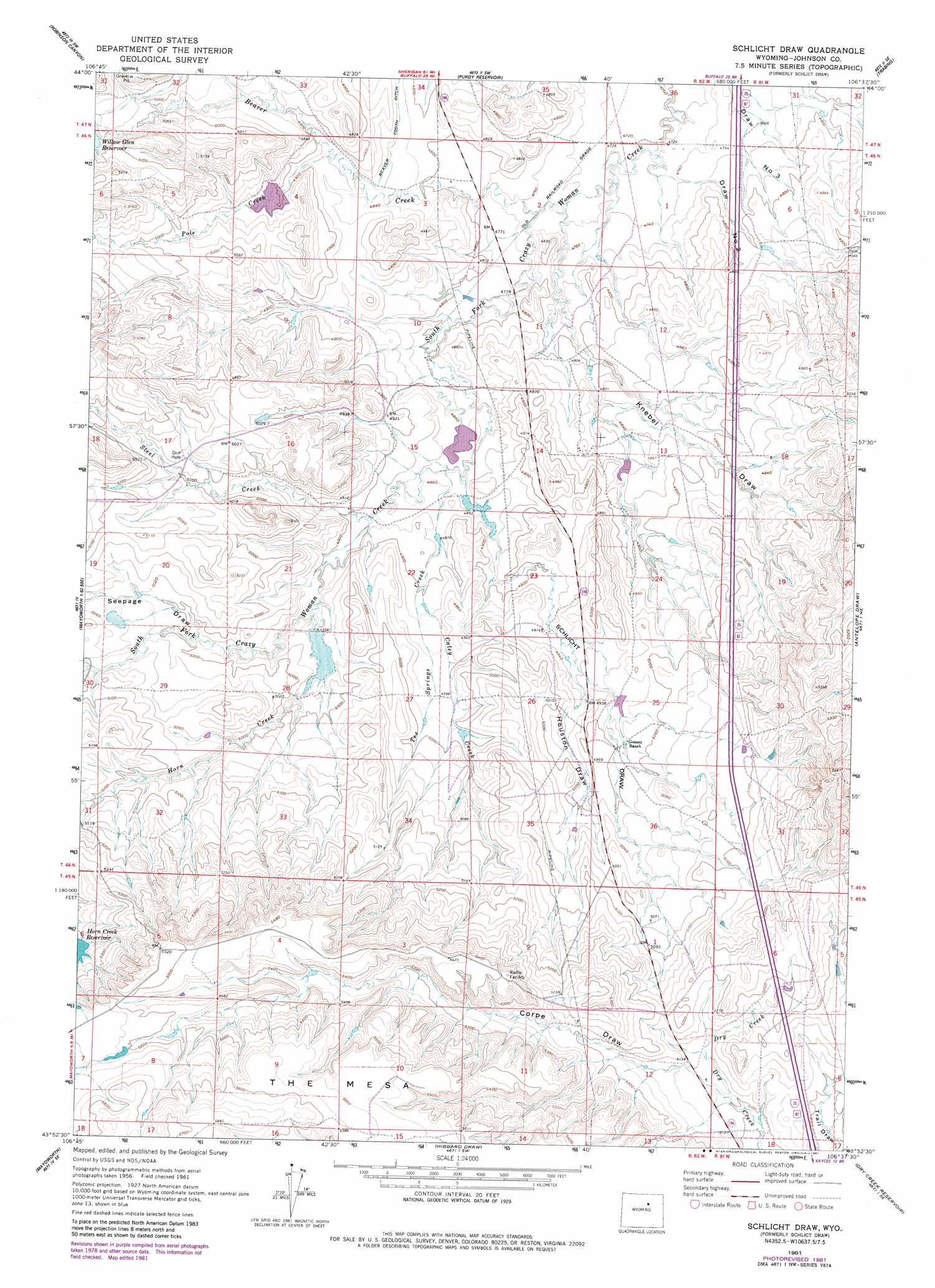
USGS Topo Quad 43106h6 - 1:24,000 scale
| Topo Map Name: | Schlicht Draw |
| USGS Topo Quad ID: | 43106h6 |
| Print Size: | ca. 21 1/4" wide x 27" high |
| Southeast Coordinates: | 43.875° N latitude / 106.625° W longitude |
| Map Center Coordinates: | 43.9375° N latitude / 106.6875° W longitude |
| U.S. State: | WY |
| Filename: | o43106h6.jpg |
| Download Map JPG Image: | Schlicht Draw topo map 1:24,000 scale |
| Map Type: | Topographic |
| Topo Series: | 7.5´ |
| Map Scale: | 1:24,000 |
| Source of Map Images: | United States Geological Survey (USGS) |
| Alternate Map Versions: |
Schlict Draw WY 1961, updated 1965 Download PDF Buy paper map Schlicht Draw WY 1961, updated 1981 Download PDF Buy paper map Schlicht Draw WY 2012 Download PDF Buy paper map Schlicht Draw WY 2015 Download PDF Buy paper map |
1:24,000 Topo Quads surrounding Schlicht Draw
Caribou Creek |
Klondike Ranch |
T A Ranch |
Ta Ranch Ne |
Crazy Woman Ranch |
Hazelton |
Robinson Canyon |
Purdy Reservoir |
Trabing |
Brown Ranch |
Packsaddle Canyon |
The Horn |
Schlicht Draw |
Antelope Draw |
Elaine Draw |
Fraker Mountain |
Mayoworth |
Hibbard Draw |
Dry Creek Reservoir |
Fourmile Reservoir |
Barnum |
Red Fork Powder River |
Kaycee |
Kaycee Ne |
Figure 8 Reservoir |
> Back to 43106e1 at 1:100,000 scale
> Back to 43106a1 at 1:250,000 scale
> Back to U.S. Topo Maps home
Schlicht Draw topo map: Gazetteer
Schlicht Draw: Canals
Beaver Tooth Ditch elevation 1476m 4842′Schlicht Draw: Dams
Horn Creek Dam elevation 1525m 5003′Horn Dam elevation 1540m 5052′
Pole Creek Irrigation Dam elevation 1502m 4927′
South Fork Dam elevation 1457m 4780′
Schlicht Draw: Reservoirs
Horn Creek Reservoir elevation 1525m 5003′Horn Creek Reservoir elevation 1595m 5232′
Horn Reservoir elevation 1540m 5052′
Pole Creek Irrigation Reservoir elevation 1502m 4927′
South Fork Reservoir elevation 1457m 4780′
Willow Glen Reservoir elevation 1538m 5045′
Schlicht Draw: Streams
Beaver Creek elevation 1444m 4737′Caley Creek elevation 1492m 4895′
Horn Creek elevation 1499m 4917′
Pole Creek elevation 1482m 4862′
Steel Creek elevation 1486m 4875′
Tex Springs Creek elevation 1476m 4842′
Schlicht Draw: Valleys
Corpe Draw elevation 1566m 5137′Draw Number 2 elevation 1446m 4744′
Houston Draw elevation 1504m 4934′
Knebel Draw elevation 1447m 4747′
Schlicht Draw elevation 1476m 4842′
Seepage Draw elevation 1518m 4980′
Schlicht Draw digital topo map on disk
Buy this Schlicht Draw topo map showing relief, roads, GPS coordinates and other geographical features, as a high-resolution digital map file on DVD:
Eastern Wyoming & Western South Dakota
Buy digital topo maps: Eastern Wyoming & Western South Dakota