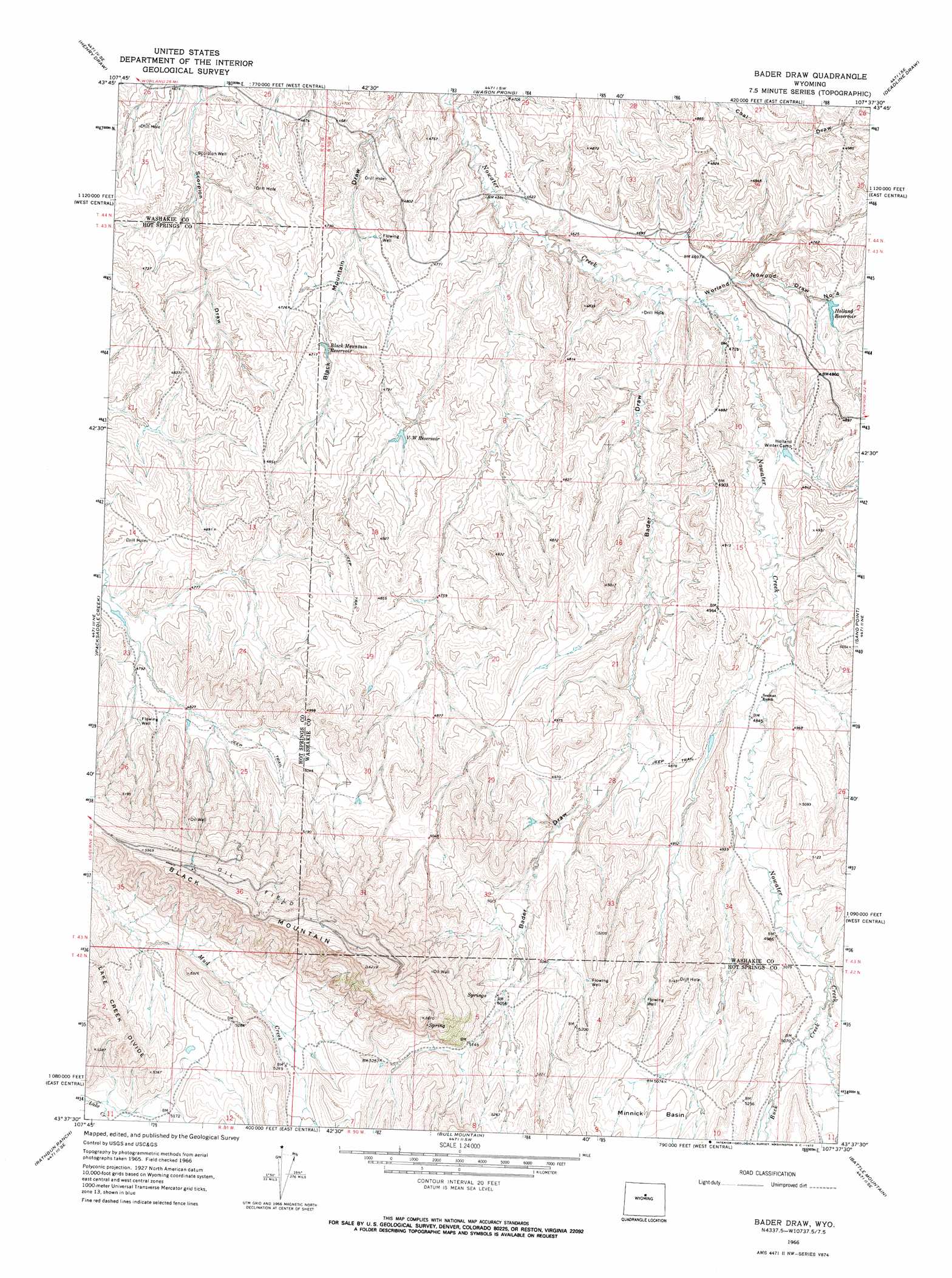
Bader Draw Topo Map Wyoming
To zoom in, hover over the map of Bader Draw
USGS Topo Quad 43107f6 - 1:24,000 scale
| Topo Map Name: | Bader Draw |
| USGS Topo Quad ID: | 43107f6 |
| Print Size: | ca. 21 1/4" wide x 27" high |
| Southeast Coordinates: | 43.625° N latitude / 107.625° W longitude |
| Map Center Coordinates: | 43.6875° N latitude / 107.6875° W longitude |
| U.S. State: | WY |
| Filename: | o43107f6.jpg |
| Download Map JPG Image: | Bader Draw topo map 1:24,000 scale |
| Map Type: | Topographic |
| Topo Series: | 7.5´ |
| Map Scale: | 1:24,000 |
| Source of Map Images: | United States Geological Survey (USGS) |
| Alternate Map Versions: |
Bader Draw WY 1966, updated 1972 Download PDF Buy paper map Bader Draw WY 2012 Download PDF Buy paper map Bader Draw WY 2015 Download PDF Buy paper map |
1:24,000 Topo Quads surrounding Bader Draw
Banjo Flats West |
Banjo Flats East |
Cabin Fork |
Castle Gardens |
Joe Emge Creek |
Zimmerman Buttes |
Henry Draw |
Wagon Prong |
Deadline Draw |
Indian Creek |
Coyote Hill |
Packsaddle Creek |
Bader Draw |
Sand Point |
Lightning Ridge |
Blue Hill |
Rathbun Ranch |
Bull Mountain |
Battle Mountain |
Cornell Gulch |
Guffy Peak |
De Pass |
Arapahoe Butte |
Cottonwood Pass |
Sioux Pass |
> Back to 43107e1 at 1:100,000 scale
> Back to 43106a1 at 1:250,000 scale
> Back to U.S. Topo Maps home
Bader Draw topo map: Gazetteer
Bader Draw: Dams
Arnold Dam elevation 1549m 5082′Bader Draw: Reservoirs
Arnold Reservoir elevation 1549m 5082′Black Mountain Reservoir elevation 1433m 4701′
Holland Reservoir elevation 1441m 4727′
V W Reservoir elevation 1435m 4708′
Bader Draw: Streams
Buck Creek elevation 1525m 5003′Bader Draw: Summits
Black Mountain elevation 1884m 6181′Bader Draw: Valleys
Bader Draw elevation 1413m 4635′Cottonwood Draw elevation 1402m 4599′
Worland Nowood Draw Number 4 elevation 1418m 4652′
Bader Draw: Wells
Scorpion Well elevation 1409m 4622′Bader Draw digital topo map on disk
Buy this Bader Draw topo map showing relief, roads, GPS coordinates and other geographical features, as a high-resolution digital map file on DVD:
Eastern Wyoming & Western South Dakota
Buy digital topo maps: Eastern Wyoming & Western South Dakota