Twin Springs Topo Map Oregon
To zoom in, hover over the map of Twin Springs
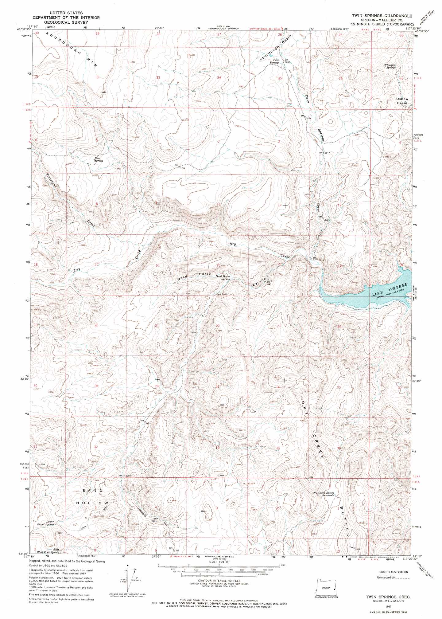
USGS Topo Quad 43117e4 - 1:24,000 scale
| Topo Map Name: | Twin Springs |
| USGS Topo Quad ID: | 43117e4 |
| Print Size: | ca. 21 1/4" wide x 27" high |
| Southeast Coordinates: | 43.5° N latitude / 117.375° W longitude |
| Map Center Coordinates: | 43.5625° N latitude / 117.4375° W longitude |
| U.S. State: | OR |
| Filename: | o43117e4.jpg |
| Download Map JPG Image: | Twin Springs topo map 1:24,000 scale |
| Map Type: | Topographic |
| Topo Series: | 7.5´ |
| Map Scale: | 1:24,000 |
| Source of Map Images: | United States Geological Survey (USGS) |
| Alternate Map Versions: |
Twin Springs OR 1967, updated 1971 Download PDF Buy paper map Twin Springs OR 1967, updated 1971 Download PDF Buy paper map Twin Springs OR 2011 Download PDF Buy paper map Twin Springs OR 2014 Download PDF Buy paper map |
1:24,000 Topo Quads surrounding Twin Springs
Namorf |
Harper |
Kane Spring Gulch |
Double Mountain |
Mitchell Butte |
Avery Creek |
Keeney Ridge |
Sourdough Spring |
Grassy Mountain |
Owyhee Dam |
Rufino Butte |
Hurley Flat |
Twin Springs |
The Elbow |
Owyhee Ridge |
Copeland Reservoirs |
Wall Rock Springs |
Quartz Mountain Basin |
Pelican Point |
Three Fingers Rock |
Cedar Mountain |
Big Mud Flat |
Diamond Butte |
Rooster Comb |
Bannock Ridge |
> Back to 43117e1 at 1:100,000 scale
> Back to 43116a1 at 1:250,000 scale
> Back to U.S. Topo Maps home
Twin Springs topo map: Gazetteer
Twin Springs: Basins
Sand Hollow elevation 1054m 3458′Twin Springs: Reservoirs
Dry Creek Buttes Reservoir elevation 1157m 3795′Twin Springs: Springs
Dead Horse Spring elevation 892m 2926′East Spring elevation 1162m 3812′
East Wall Rock Spring elevation 1153m 3782′
Lower Burnt Spring elevation 1105m 3625′
Twin Springs elevation 989m 3244′
Whiskey Spring elevation 994m 3261′
Twin Springs: Streams
Freezeout Creek elevation 916m 3005′Twin Springs Creek elevation 826m 2709′
Twin Springs: Summits
Burnt Mountain elevation 1288m 4225′Dry Creek Buttes elevation 1307m 4288′
Hammond Hill elevation 1161m 3809′
Twin Springs: Valleys
Dead Horse Canyon elevation 847m 2778′Twin Springs digital topo map on disk
Buy this Twin Springs topo map showing relief, roads, GPS coordinates and other geographical features, as a high-resolution digital map file on DVD: